
Greater Grand Forks Greenway facts for kids
Quick facts for kids Greater Grand Forks Greenway |
|
|---|---|

Memorial in the Greater Grand Forks Greenway commemorating the 1997 flood and other past floods
|
|
| Type | Public park |
| Location | On the banks of the Red River and Red Lake River in Grand Forks, North Dakota and East Grand Forks, Minnesota |
| Area | 2,200 acres (9 km2) |
| Operated by | City of Grand Forks, City of East Grand Forks, Grand Forks Park District, Minnesota Department of Natural Resources |
| Status | Open year round |
The Greater Grand Forks Greenway is a huge park area that runs along the Red River and Red Lake River. It's located in the cities of Grand Forks, North Dakota and East Grand Forks, Minnesota, which are often called Greater Grand Forks. This amazing green space is super big, covering 2,200 acres (about 9 square kilometers). That's more than twice the size of New York City's famous Central Park!
The Greenway has a long system of paths, stretching about 20 miles (32 km). These paths are perfect for biking, walking, jogging, and rollerblading. In 2007, it was even named a National Recreation Trail by the National Park Service, which means it's a special place for outdoor fun.
Inside the Greenway, you'll find several city parks and golf courses on both sides of the river. There are also cool spots to watch wildlife, a state campground, and places to go fishing. You can enjoy pretty wildflower gardens and fields for sports like softball, basketball, and disc golf.
Contents
Why was the Greenway built?
The Greenway was created after a really big flood in 1997, called the Red River Flood of 1997. The land where the Greenway now sits is a floodplain, which means it's a low area next to the rivers that often floods. Before 1997, many homes and businesses were in this area. The flood badly damaged or destroyed them.
To protect the cities from future floods, a massive new dike system was built. These dikes are like big walls that hold back the river water. Building them meant that some neighborhoods had to be removed. The Greenway now covers the land between these new dikes and the rivers.
So, the Greenway has two main jobs:
- It gives people a fantastic place to have fun outdoors all year long.
- It's a key part of the flood prevention plan. Its trees and green spaces can soak up some floodwaters naturally. The dikes then provide extra protection for the city areas.
Finding your way: Trailheads
A "trailhead" is like an entrance point to the Greenway. These spots have breaks in the dikes or floodwalls, so you can easily get into the park. Most trailheads have paved parking lots. Many also have public restrooms, picnic areas, and playgrounds.
Grand Forks Trailheads
Here are some of the main trailheads in Grand Forks, listed from north to south:
- Riverside Rapids
- Riverside Park
- Community Green (near Downtown Grand Forks)
- Kannowski Park
- Lincoln Drive Park
- Lincoln Golf Course
East Grand Forks Trailheads
Here are some of the main trailheads in East Grand Forks, listed from north to south:
- River Heights
- Sherlock Park
- Rotary Park (in Downtown East Grand Forks)
- Griggs Park
Cool places inside the Greenway
The Greenway is packed with interesting spots on both sides of the river.
Grand Forks side
Parks to explore
The Grand Forks Park District takes care of several parks within the Greenway on the Grand Forks side.
- Riverside Park: This is one of the oldest parks in Grand Forks, located at the far north end of the Greenway. It has a playground, restrooms, picnic spots, and an outdoor pool. North of the park, you'll find the Riverside Dam, which now has a waterfall called Riverside Rapids. There's also a boat launch and a walking bridge connecting to the East Grand Forks side.
- Kannowski Park: Located just south of Downtown Grand Forks, this park used to be called Central Park. It's a smaller park with a playground, restrooms, and picnic areas. It was renamed to honor Frances Kannowski, who was the first female superintendent of a park district in the United States!
- Lincoln Drive Park: This park is further south, in an area where a neighborhood used to be before the 1997 flood. It has a warming house (which you can rent for parties!), big picnic areas, playgrounds, and a wildflower garden. You can also see displays about the old neighborhood. South of the park is a steep part of the dike, known as "the sledding hill," which is super popular in winter!
Lincoln Golf Course
The Lincoln Golf Course is located within the Greenway. It's the oldest golf course in North Dakota, started way back in 1909. It used to be an 18-hole course, but it was changed to a 9-hole course because of the space needed for the dikes. There's a small clubhouse with snacks, a pro shop, and restrooms. East of the golf course is the Pat Owens pedestrian bridge, named after the mayor of Grand Forks during the 1997 flood. This bridge crosses the river and connects to the Greenway in East Grand Forks, Minnesota.
Downtown Grand Forks Greenway
The part of the Greenway that runs through Downtown Grand Forks is really well-kept. You'll see brick entrances and flags celebrating the Greenway.
South of the Sorlie Bridge (DeMers Avenue), there's a monument overlooking the Red River. It shows how high past floods reached, and how much higher the 1997 flood was. There are wide stairs and terraced levels leading down to it. This area also has a labyrinth design on the ground. North of the bridge is the "Community Green," with trees, shrubs, a small gazebo, and parking.
The Grand Forks Town Square is right next to the Greenway, at DeMers Avenue and Third Street. It has an amphitheater and hosts many community events, like the Grand Cities Art Fest in June and the Farmers' Market in summer.
East Grand Forks side
Parks to explore
The East Grand Forks side of the Greenway has three main parks:
- Sherlock Park: Near downtown East Grand Forks, it has the city's only public pool, picnic spots, and a large playground.
- Griggs Park: Located near where the Red River and Red Lake River meet, this park has school athletic fields and a boat ramp for river access.
- O'Leary Park: This park is heavily wooded and sometimes attracts wildlife. It also has athletic fields, picnic areas, and a playground.
Valley Golf Course
On the far north side of the Greenway in East Grand Forks is the 18-hole Valley Golf Course. It had to be redesigned because of the flood control system. It includes a clubhouse with banquet facilities.
Downtown East Grand Forks Greenway
In downtown East Grand Forks, the flood protection is a bit different. Instead of earthen dikes, a flood wall is put together piece-by-piece when there's a flood. This means people in downtown East Grand Forks can enjoy a direct view of the Red River most of the time. The "dry side" of the flood wall has an area called The Boardwalk, a brick path with restaurants and bars that look out over the river. On the "wet side" (in the Greenway) is Rotary Park, which has a cool fountain.
Campground
Just north of downtown East Grand Forks, you'll find a campground. It's run by the Minnesota Department of Natural Resources and is part of the Red River State Recreation Area. This campground has many campsites, some with water, electricity, and sewer hookups, and others without. It's located where the Sherlock Park neighborhood used to be before the 1997 flood. All the homes there were destroyed and removed, and now it's part of the Greenway!
Images for kids
-
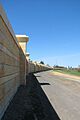
Floodwall in the Greenway directly north of downtown Grand Forks
-
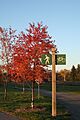
A sign near the Olson/Elmwood access in Grand Forks
-
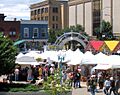
Grand Cities Art Fest 2006 in downtown Grand Forks's Town Square
-
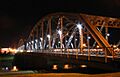
The Sorlie Bridge (DeMers Avenue) spans the Red River in the downtown areas of Grand Forks and East Grand Forks. On the Grand Forks side of the bridge are located Town Square and the Community Green. On the Minnesota side is Rotary Park.


