
1997 Red River flood facts for kids

The Sorlie Bridge connecting Grand Forks and East Grand Forks became submerged on April 17
|
|
| Date | April 1997 |
|---|---|
| Location |
|
| Deaths | 0 |
| Property damage | $3.5 billion |
The Red River flood of 1997 was a huge flood that happened in April and May 1997. It affected the Red River of the North in Minnesota, North Dakota, and Southern Manitoba, Canada. This was the biggest flood on the river since 1826. The flood spread across the entire Red River Valley. It hit cities like Fargo and Winnipeg, but it was worst for Grand Forks and East Grand Forks. In these two cities, the floodwaters went more than 3 miles (5 km) inland. They covered almost everything in the towns. The total damage in the Red River region was about $3.5 billion. This flood happened because of a lot of snow and very cold temperatures.
In Manitoba, the flood caused over $500 million in damages. The Red River Floodway, a special waterway finished in 1968, helped a lot. It moved some of the floodwaters around Winnipeg, saving the city from being flooded. After the 1997 flood and its huge losses, the United States and state governments improved the flood protection system. They turned old building areas near the river into the Greater Grand Forks Greenway. This area now has places for fun all year and helps soak up floodwaters naturally. A system of dikes, which are like walls, was built to protect Grand Forks and East Grand Forks.
In Grand Forks, thousands of people, including Air Force members, tried to get ready for the flood. They built sandbag dikes, which are walls made of sandbags, to hold back the water. These dikes were built based on a guess that the river would reach 49 feet (14.9 meters). But the river actually rose to 54 feet (16.5 meters) in Grand Forks. The mayor of Grand Forks, Pat Owens, had to tell over 50,000 people to leave their homes. This was most of the city's population, as a huge area became flooded. A big fire also started in Grand Forks. It burned eleven buildings and sixty apartment units before firefighters put it out.
People affected by the flood in the U.S. received help from all over the country. They also got billions of dollars in money from the government. Some people criticized city officials and flood forecasters. This was because their guesses for the flood levels were very different from what actually happened.
After the flood, the Federal Emergency Management Agency (FEMA) worked with Grand Forks and East Grand Forks. They cleared out homes and businesses from a large area near the river. This was because they knew future floods would happen. New dikes were built further away from the river on both sides. These dikes help protect the cities from future floods. They also turned the flood plain along the river into the Greater Grand Forks Greenway. This area now has parks, a state campground, and a 20-mile (32 km) path for biking and walking.
Contents
History of Flooding

The Red River of the North has flooded many times over hundreds of years. It often floods in the spring for a few reasons. The river flows north, the land is very flat, and ice forms on the river. When spring comes, snow melts from south to north, which is the same direction the river flows. Sometimes, the high water hits ice on the river and backs up. This causes the water to spread out of the river banks. The very flat land, which used to be an ancient lake bed, and the gentle slope of the river also cause big floods in the area.
There were serious floods in 1948 and 1950. The 1950 Red River flood reached 30 feet (9.2 meters) in Winnipeg. This caused the biggest evacuation in Canada's history. About 70,000 to 100,000 people had to leave their homes. The damage was estimated at $606 million in Canadian money (from 1997). After this flood, the governments of Manitoba and Canada built flood safety measures.
The first known records of floods on the Red River are from the 1770s. Big floods also happened throughout the 1800s and 1900s, including in 1979. People living there and officials wrongly thought that homes safe in 1979 would also be safe from any future flood.
How the Flood Affected People
North Dakota and Minnesota
The Red River forms the border between Minnesota and North Dakota. There are "sister cities" on opposite sides of the river. Grand Forks, North Dakota and East Grand Forks, Minnesota were the most affected by the 1997 flood. Fargo, North Dakota/Moorhead, Minnesota and Wahpeton, North Dakota/Breckenridge, Minnesota also had bad flooding. Much of the flooding happened not just from the river rising, but also from water spreading over the land. This was because melted snow could not drain away. Temporary dikes were built along the river and around towns, but sometimes they were not strong enough.
It was hard for the cities to get ready for such a huge flood. The National Weather Service (NWS) predicted the river would reach 49 feet (14.9 meters). This was the highest level during the 1979 flood. The cities built dikes to this height, but the river kept rising past it. The NWS was surprised and did not change its prediction until April 16. This was the same day the river reached 49 feet.
The dikes in the low-lying Lincoln Drive area of Grand Forks broke first. This happened early on April 18, as the river kept getting higher. Other dikes in Grand Forks and East Grand Forks also failed that day and the next. Thousands of homes were flooded. During this time, Grand Forks mayor Pat Owens told over 50,000 people to leave. This was most of the city's population. It was the largest evacuation in the United States since the Civil War.

Water reached areas more than two miles (3 km) away from the Red River. This meant all of East Grand Forks and 75% of Grand Forks had to be evacuated. School was canceled in both cities for the rest of the school year. Classes at the University of North Dakota were also stopped. All ways to travel between the two cities were cut off. East Grand Forks residents went to nearby Crookston, many staying at the University of Minnesota Crookston. Grand Forks residents were told to leave on April 18. Many went to Grand Forks Air Force Base, staying in airplane hangars with over 3,000 beds. Many also went to hotels and homes in towns outside the city.
The river reached its highest point of 54.35 feet (16.6 meters) on April 21. The water level did not drop below 49 feet (14.9 meters) until April 26. Because water drained very slowly from the lowest areas, some homeowners could not visit their damaged homes until May. By May 30, the Red River had gone down below flood levels everywhere in North Dakota.
Manitoba's Flood Fight

The province of Manitoba finished the Red River Floodway in 1968. They also built strong dikes in eight towns south of Winnipeg. Clay dikes and dams were built in the Winnipeg area too. Other flood control structures built later included the Portage Diversion and the Shellmouth Dam on the Assiniboine River. Even with these protections, the 1997 flood reached 21.6 feet (6.6 meters) in Manitoba. It caused 28,000 people to leave their homes and $500 million in damage to property.
The 1997 flood was a "100-year flood." This means it was a flood so big it's only expected to happen once every 100 years. It almost overwhelmed Winnipeg's flood protection system. The Winnipeg Floodway was designed to handle 60,000 cubic feet per second (1,700 cubic meters per second) of water. But the 1997 flood had 63,000 cubic feet per second (1,784 cubic meters per second).
To help, the province changed how the Floodway usually worked on the night of April 30 / May 1. This stopped water in Winnipeg from rising above its safe limit. But it caused more flooding upriver. Winnipeg Mayor Susan Thompson announced that the limit had been reached. She thought this meant the flood had peaked, or reached its highest point. So, people stopped filling sandbags, and reporters left the city. But the water kept rising inside and outside the city until May 3 / May 4. City officials later said the peak was on May 1, but scientific reports show it was May 3 or 4.
Towns upriver from Winnipeg had seen videos of buildings burning and covered in water in Grand Forks. So, they built ring dikes around their homes. The province of Manitoba called in the Canadian Forces, the Royal Canadian Mounted Police, and the Department of Natural Resources. Many people chose to leave, including those from Morris. They only had two days to get to Winnipeg. Thousands of volunteers helped build sandbag dikes around homes. A 42 km (26 mi) long emergency dike, called the Brunkild Z-dike, was built in just a few days. This happened when officials realized water spreading over the land threatened Winnipeg. It cost $10 million (Canadian).
Almost all the ring dikes around the towns held strong. Only the one at Ste. Agathe did not. The town's dike system was ready for the river coming from the south. But the river had spread out widely, and floodwaters covered the town from the west. At its highest point in Canada on May 4, the Red River covered 1,840 square kilometers (710 square miles). More than 2,560 square kilometers (990 square miles) of land were underwater. This earned it the nickname "Red Sea."
While the flooding was still happening, the Canadian government called a quick election. Some politicians from the province asked for a delay until the flood was under control. When the Prime Minister decided to go ahead with the election, one politician, Reg Alcock, turned his campaign office into a volunteer help center. He spent his time helping with flood relief instead of campaigning, and he won his election again.
What Happened After
In July, Canadian Prime Minister Jean Chrétien and United States President Bill Clinton created a special group. It was called the International Red River Basin Task Force. This group had members from both countries. Their job was to find better ways to predict floods.
The province of Manitoba asked the International Joint Commission (IJC) to write a report about the flood. They also wanted ideas to make Winnipeg safer from future floods. Because of this study, the province made the floodway wider between 2004 and 2010.
Images for kids
-
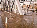
The Sorlie Bridge connecting Grand Forks and East Grand Forks became submerged on April 17
-
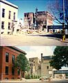
A before and after view of a building that caught fire in downtown Grand Forks during the 1997 Red River flood.
-
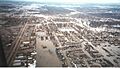
Grand Forks after a levee overtopped and Grand Forks was evacuated
-
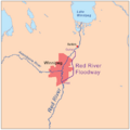
Red River Floodway near Winnipeg
