
1997 Red River flood in the United States facts for kids

The Sorlie Bridge connecting Grand Forks and East Grand Forks became submerged on April 17
|
|
| Date | April 1997 |
|---|---|
| Location | Fargo, ND Moorhead, MN Greater Grand Forks -Grand Forks, ND -East Grand Forks, MN |
| Deaths | 0 |
| Property damage | $3.5 billion |
The Red River flood of 1997 was a huge flood that happened in April 1997. It affected areas along the Red River of the North in North Dakota and Minnesota. The floodwaters spread across the entire Red River Valley.
Cities like Fargo and Winnipeg were impacted. However, Grand Forks and East Grand Forks faced the most damage. In these "twin cities," floodwaters reached more than 3 miles (5 km) inland. They covered almost everything. The total cost of damages in the Red River region was about $3.5 billion.
This big flood happened because of heavy snowfall and very cold temperatures. Even though river levels in Fargo reached record heights, the city was mostly safe. This was thanks to several dikes (special walls built to hold back water). Fargo had only minor damage.
But in Grand Forks, the river rose to 54 feet (16.5 m). This was much higher than the 49-foot (14.9 m) flood estimate from the National Weather Service. In East Grand Forks, nearly every home was damaged by the floodwaters. The mayor of Grand Forks, Pat Owens, had to tell over 50,000 people to leave their homes. A large part of the city ended up underwater. A big fire also started in Grand Forks, destroying eleven buildings and sixty apartment units before it was put out.
People affected by the flood received help from all over the country. They also got billions of dollars in government aid. City leaders and flood experts were criticized because their predictions were so different from what actually happened. After the flood, Fargo, Grand Forks, and East Grand Forks built new dikes. These new dikes help protect them from future floods. The Greater Grand Forks area also started to rebuild around the river. They created a campground, a park, and new shopping areas where homes used to be.
Contents
Understanding the Red River and Past Floods
The Red River creates the border between North Dakota and Minnesota. Many "sister cities" are located right on this border. Examples include Grand Forks, North Dakota and East Grand Forks, Minnesota. Also, Fargo, North Dakota and Moorhead, Minnesota (known as Fargo-Moorhead) are sister cities.
The Red River has flooded many times over hundreds of years. This puts lives and property at risk. The river is very likely to flood because it flows north. When spring comes, snow melts from south to north, following the river's flow. Sometimes, this extra water can hit unmelted ice further north, causing the water to back up. The flat land and gentle slope of the river also make flooding worse.
The first records of Red River floods date back to the 1770s. Big floods happened throughout the 1800s and 1900s. A major flood occurred in 1979. Homes that were not damaged in that flood were wrongly thought to be safe from future floods.
Why the 1997 Flood Was So Bad

Five main things made the 1997 flood so severe:
- Heavy rainstorms in the fall of 1996 made the ground very wet. This meant it could not soak up much water later.
- There was a lot of snow during the winter of 1996–1997. Fargo got 98.6 inches (250 cm) of snow. Grand Forks, downstream, got 117 inches (297 cm). Record snowfalls covered the entire Red River of the North's watershed (the area of land that drains into the river).
- The Upper Midwest had extremely cold temperatures that winter. From November 1996 to March 1997, the temperature in Grand Forks only reached 40 degrees Fahrenheit (4.4 °C) three times. Because it was so cold, the snow did not melt slowly over time.
- Then, starting on March 19, 1997, the temperature stayed above freezing for 27 days in a row. This sudden warmth in April melted the deep snow too quickly for the river to handle.
- A strange blizzard (a severe snowstorm) hit the Red River Valley on April 5, 1997. It dumped a lot of freezing rain and snow.
- Smaller rivers and streams that flow into the Red River also peaked (reached their highest levels) at the same time. This added even more water to the Red River.
Getting Ready for the Flood
The 1997 Red River flood caused over $815 million in damages. The first flood warning came on February 13, 1997, from the National Weather Service. It said there was a "severe spring snowmelt potential" for the Red River.
On February 27, a meeting in Fargo predicted how high the river would rise. For Grand Forks, they expected the Red River to reach 49 feet (14.9 m). On March 24, the Corps of Engineers suggested Grand Forks build dikes up to 52 feet (15.8 m). This would give them three feet of extra protection.

The Federal Emergency Management Agency (FEMA) told Grand Forks residents to buy flood insurance. But only about a thousand out of 52,000 residents did. Later, studies showed that most people knew about flood insurance. However, they did not buy it because they believed the National Weather Service's lower prediction. They thought the river would not get high enough to cause a flood.
On March 31, the North Dakota National Guard used helicopters to drop sand on the river's ice. They hoped the sun's heat would melt the ice and prevent ice jams. This was the biggest effort of its kind in North Dakota's history. Starting on April 3, people began filling sandbags and building dikes every day. Residents, college students, and Air Force personnel placed about 3.5 million sandbags around the river.
On April 16, Mayor Pat Owens suggested that Grand Forks residents leave the city voluntarily. The next day, about 500 airmen and women from Grand Forks Air Force Base helped watch over the dikes.
The Flood Hits Hard
Fargo's Experience with the Flood

The Red River reached its highest point in Fargo at 39.5 feet (12 m) on April 17. But the efforts to build dikes worked. They stopped the water from flooding most of the city. An emergency dike was built, and volunteers added sandbags to make another dike taller.
Fargo's mayor at the time, Bruce Furness, said, "We came very, very close to losing parts of Fargo...it took a lot of effort by a lot of people—a great many of them high school and college students—to save the city. I was very proud of them."
Grand Forks and East Grand Forks Under Water

People in Grand Forks felt a threat, but they could not prepare for such a huge flood. The National Weather Service (NWS) had predicted the river would reach 49 feet (14.9 m). This was the river's highest level during the 1979 flood. The cities had built their dikes to this height. But the river kept rising past it, surprising the NWS. They did not update their forecast until April 16, the day the river actually reached 49 feet.
The dikes in the low-lying Lincoln Drive neighborhood of Grand Forks were the first to break. This happened early on April 18. Other dikes in Grand Forks and East Grand Forks failed that day and the next. Thousands of homes were flooded.

Water ended up reaching areas more than two miles (3 km) away from the Red River. This meant everyone in East Grand Forks had to leave. Also, 75% of Grand Forks residents had to evacuate. School was canceled in both cities for the rest of the school year. Classes at the University of North Dakota were also stopped.
The river reached its highest point at 54.35 feet (16.6 m) on April 21. The water level did not drop below 49 feet (14.9 m) until April 26. This flood was even higher than the worst flood before it, which happened in 1826. Because the water drained so slowly from the lowest areas, some homeowners could not visit their damaged property until May. By May 30, the Red River had gone down below flood levels everywhere in North Dakota.
Leaving Their Homes: Evacuations
When the dikes in Grand Forks could not hold back the river, Mayor Pat Owens ordered over 50,000 people to leave. This was one of the largest civilian evacuations in the United States since the Civil War. She later said, "If I evacuate this city and nothing happens they're gonna impeach me. But if I don't, we're going to lose lives."
All roads between the two cities were cut off. East Grand Forks residents went to nearby Crookston, many staying at the University of Minnesota Crookston. Grand Forks residents, who were told to leave on April 18, went to Grand Forks Air Force Base. They stayed in airplane hangars with more than 3,000 beds.
With help from the National Guard and Air Force, hundreds of patients were moved from local hospitals. No one was hurt during these moves. Many residents also went to motels and homes in nearby towns. Some Grand Forks residents were upset with the National Weather Service. They felt the wrong prediction had stopped them from saving their belongings. One resident said, "If they'd said earlier the river would hit 52 feet, I would have moved my stuff out of my house. At 49, it was safe."
Downtown Grand Forks Fire

The flood made national news. The most famous images are probably of the fire that started on April 19 in downtown Grand Forks. It was surrounded by floodwaters. Eleven buildings and sixty apartments were destroyed. The Grand Forks Herald building was completely ruined, along with 120 years of its old newspapers.
Firefighters could not put out the fire right away. They first had to rescue nearly forty people from a nearby apartment complex who had not left. Also, their fire trucks could not reach the buildings because the water was too high. The water pressure from hoses and hydrants was too weak. The National Guard put fire trucks on large tractor-trailers to keep them from flooding. This helped firefighters fight the blaze.
Two special aircraft rescue and firefighting trucks from the Grand Forks International Airport were also brought in. Their engines were higher off the ground, so they did not get clogged by the floodwaters. Several hours after the fire started, a plane dropped fire retardant. Helicopters also made sixty drops, totaling 120,000 gallons of water. Three firefighters were treated for being too cold after walking through the floodwater. The fire was later found to be caused by an electrical problem from the floodwater.
Help and Damages

The flood and fire got national attention. Joan Kroc, who inherited money from McDonald's, secretly gave $15,000,000. This money was divided into $2,000 for each damaged household. (Some homeowners got less because so many homes were destroyed; 7,500 households received funds). Another secret donor gave $5 million, which was given out in $1,000 amounts.
In November 1997, North Dakota Governor Ed Schafer said that 50,000 volunteers had helped victims. They served over 2 million meals. Communities also received clothes and supplies donated from every U.S. state. The rock band KISS donated money from special T-shirt sales at a concert in Fargo to help with flood relief.

Overall, there was $3.5 billion in damages to Grand Forks and East Grand Forks. This made it the eighth most expensive natural disaster in the U.S. since 1903. Across North Dakota and Minnesota, 4.5 million acres (18,210 km2) of land were covered in water. Thousands of people had to move after the disaster.
In May 1997, the Red Cross checked 8,000 homes in North Dakota. They found that 519 homes, 53 mobile homes, and 73 apartments were destroyed. Another 701 homes, 69 mobile homes, and 175 apartments had major damage. Inspectors also reported that 5,959 homes, 166 mobile homes, and 497 apartments had minor damage. Over 5,200 businesses were destroyed, damaged, or affected. In Grand Forks alone, 75% of homes, 315 businesses, and 16 out of 22 local schools were flooded. East Grand Forks had over 500 homes that were declared unsafe. Only eight homes were not damaged by the flood. Grand Forks lost only 3% of its people from 1997 to 2000. East Grand Forks lost nearly 17% of its residents. No one died in the flood itself.
Protecting Against Future Floods

The National Weather Service has changed how it predicts spring floods. Better technology and more money have helped them map the entire Red River bottom. They now have more flood monitoring tools and up-to-date satellite images of the river at different flood levels.
The area still has floods, like a major one in April 2006. However, the Red River did not reach the 1997 level. It caused only minor damage, mostly in rural areas. This included water over roads and bridges. The reason Grand Forks and East Grand Forks had little damage was mainly because of the improved dikes and the Greenway park area.
New dikes have been built in Fargo, Grand Forks, and East Grand Forks. For Greater Grand Forks, the system of levees and new "invisible floodwalls" was finished in 2007. It cost several hundred million dollars. The land along both sides of the river has been turned into a huge park called the Greater Grand Forks Greenway.
Since the flood, Grand Forks' recovery has been used as an example for other communities hit by natural disasters. After Hurricane Katrina in 2005, Grand Forks helped the city of Biloxi, Mississippi. Grand Forks mayor Michael Brown said it was important "to utilize the experience from those people who went through those disasters, like our fire chief, police chief and public works directors." So, they went to Biloxi and shared what they had learned. Grand Forks leaders met with Biloxi officials. They sent a list of contacts and a 24-page booklet. It explained how to work with volunteer groups and FEMA. A Biloxi city official said Grand Forks "just helped us to understand what we were looking at, and gave us some direction to go in, which was really needed, with the rebuilding and the recovering."
By 2007, the population of Grand Forks was back to what it was before the flood. East Grand Forks mayor Lynn Stauss said, "We like to call ourselves the poster child of flood recovery because we think we showed how different governments working together could make it happen."
Images for kids
-
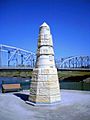
Obelisk in Grand Forks remembering the 1997 flood and others
-
East Grand Forks City Hall


