
Green Island (California) facts for kids

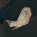
USGS aerial imagery of Green Island
|
|

Green Island
Location in San Francisco Bay Area

Green Island
Location in California

Green Island
Location in the United States
|
|
| Geography | |
|---|---|
| Location | Northern California |
| Coordinates | 38°12′09″N 122°18′16″W / 38.20250°N 122.30444°W |
| Adjacent bodies of water | Napa River |
| Highest elevation | 23 ft (7 m) |
| Administration | |
|
United States
|
|
| State | |
| County | Napa |


Green Island is a small piece of land surrounded by water. It is located in the Napa River in Napa County, California. This island is found just before the Napa River flows into San Pablo Bay. San Pablo Bay is a part of the larger San Francisco Bay.
Scientists from the United States Geological Survey (USGS) measured Green Island's height in 1981. They found it was about 23 feet (7 meters) above sea level.
Contents
Where is Green Island?
Green Island is in Northern California. It sits in the lower part of the Napa River. This river is important because it connects to San Pablo Bay. The island is part of Napa County, which is known for its beautiful landscapes.
Location in the Bay Area
The island is located in a busy area. Many other islands are nearby. These include Mare Island, Knight Island, and Russ Island. You can see many of these islands from the air. They are all part of the unique environment of the San Francisco Bay Area.
Protecting Green Island
Green Island is not just a random piece of land. It is an important part of a special protected area. This area is called the Napa-Sonoma Marshes Wildlife Area.
What is a Wildlife Area?
A wildlife area is a place set aside to protect nature. It helps keep animals and plants safe. The Napa-Sonoma Marshes Wildlife Area is managed by the state. This means people work to make sure the environment stays healthy. They protect the natural homes, called habitats, for many different species.
Why is it Important?
Islands like Green Island are very important for wildlife. They provide safe places for birds to nest. They also offer homes for other animals. These areas help keep the natural balance of the ecosystem. Protecting these places helps us learn about nature. It also makes sure these habitats are there for future generations.
Images for kids
-
USGS aerial imagery of Green Island
-
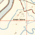
Green Island on a 1951 USGS topographic map.
-
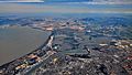
An aerial view of the Napa River flowing into San Pablo Bay. Many islands are visible.
