
Knight Island (California) facts for kids

USGS aerial imagery of Knight Island
|
|

Knight Island
Location in San Francisco Bay Area

Knight Island
Location in California

Knight Island
Location in the United States
|
|
| Geography | |
|---|---|
| Location | Northern California |
| Coordinates | 38°08′09″N 122°17′58″W / 38.13583°N 122.29944°W |
| Adjacent bodies of water | Napa River |
| Highest elevation | 3 ft (0.9 m) |
| Administration | |
|
United States
|
|
| State | |
| County | Solano |
Knight Island is a special island located in the Napa River in Northern California. It's found just before the river flows into San Pablo Bay, which is a part of the larger San Francisco Bay. This island is mostly covered by water, meaning it's often submerged, especially during high tides.
Knight Island is in Solano County. It's not just any island; it's an important part of the Napa-Sonoma Marshes Wildlife Area. In 1981, the United States Geological Survey (USGS) measured its elevation as only 3 feet (about 1 meter) above sea level. This low elevation makes it a unique and valuable marshland.
Contents
Where is Knight Island?
Knight Island is situated in the lower part of the Napa River. This river is a major waterway in Northern California that eventually connects to San Pablo Bay. San Pablo Bay is a large body of water that acts as a northern extension of the famous San Francisco Bay.
The island's exact location can be found using its coordinates: 38°08′09″N 122°17′58″W / 38.13583°N 122.29944°W. Being in Solano County, it's part of a region known for its wetlands and wildlife habitats.
A Home for Wildlife
Knight Island is a key part of the Napa-Sonoma Marshes Wildlife Area. This area is a huge protected space that includes many wetlands, marshes, and waterways. These types of habitats are super important for many different kinds of animals and plants.
Marshes like Knight Island act like natural filters for water, helping to keep the bay clean. They also provide safe places for birds to nest and feed. Many fish and other aquatic creatures also rely on these marshy areas for their survival.
What is a Marsh?
A marsh is a type of wetland that is often flooded with water, either saltwater, freshwater, or a mix of both. Marshes are usually covered with soft, wet soil and grasses. They are different from swamps, which have more trees.
Because Knight Island is "mostly-submerged," it means that much of its land is regularly covered by the tides. This creates the perfect conditions for marsh plants to grow. These plants can handle being in salty water and help to create a stable environment for wildlife.
Why is Knight Island Important?
Islands like Knight Island play a big role in the health of the San Francisco Bay ecosystem. They help to protect the coastline from erosion and provide a buffer against storms.
They are also vital for biodiversity. Many species of migratory birds use these marshes as a stopping point on their long journeys. Other animals, like various types of fish, crabs, and insects, live in these marshes all year round. Protecting places like Knight Island helps to ensure that these animals have a place to live and thrive.
Images for kids
-
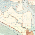
Knight Island as it appears on a 1951 USGS topographic map.


