Green Lakes State Park facts for kids
Quick facts for kids Green Lakes State Park |
|
|---|---|
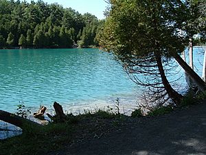
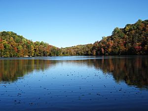
Green Lake, seen from its eastern shore. The lake's unusual blue-green color is due to annual "whitings" that leave suspended mineral solids in its water. The mineral content of the water also makes the lake meromictic, which is quite rare and which has led to intense scientific study of the lake for nearly a century.
|
|
| Lua error in Module:Location_map at line 420: attempt to index field 'wikibase' (a nil value). | |
| Type | State park |
| Location | Manlius, New York |
| Area | 2,200 acres (890 ha) |
| Created | 1928 |
| Operated by | New York State Office of Parks, Recreation and Historic Preservation |
| Visitors | 1,687,000 (in 2022) |
| Status | Open year round |
Green Lakes State Park is a beautiful New York State Park. It is located east of Syracuse in Manlius. The park is famous for its amazing scenery. It also has a special golf course designed by Robert Trent Jones.
The park is home to two unique lakes: Green Lake and Round Lake. These lakes have a striking blue-green color. They sit at the bottom of a gorge that is over a mile long. These lakes and the gorge were formed during the ice ages. They show off some of New York's unusual geology. Green Lake is 65 acres wide and 195 feet deep. Round Lake is 34 acres wide and 170 feet deep.
Green Lakes State Park covers about 1,955 acres. Around 1,000,000 people visit it every year. Almost half of the park is old-growth forest. This means it has very old and large trees. You can find huge tuliptrees, sugar maples, beech, basswood, hemlocks, and white cedars. There's even a special group of trees called the Tuliptree Cathedral. It's located southwest of Round Lake.
Contents
Fun Activities at Green Lakes Park
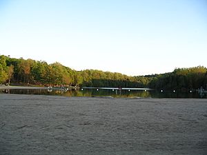
At the north end of Green Lake, there's a sandy swimming beach. It has grassy areas for sunbathing. There's also a building with changing rooms and a snack bar. Green Lake is a very popular spot for swimming in Central New York.
Next to the beach, you can rent rowboats and paddleboats in the summer. The park also offers stand-up paddleboard classes and yoga. You cannot bring your own boats or paddleboards.
Golfing and Camping Adventures
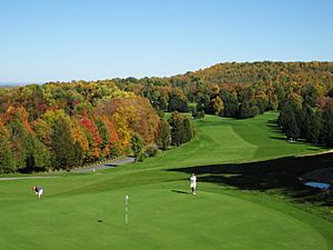
The park has an 18-hole golf course. It was designed by Robert Trent Jones. There's also a clubhouse in the park's southeast area. Above the western cliffs of Green Lake, you'll find a Frisbee golf course. There are 137 campsites and seven cabins for visitors. These offer a comfortable way to enjoy the outdoors. Many picnic areas are available, some with shelters you can reserve.
Hiking and Biking Trails
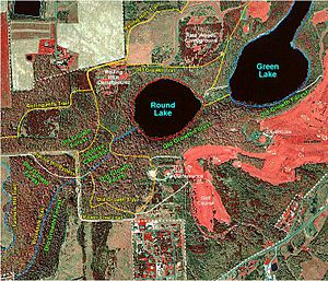
Green Lakes State Park has many hiking trails. About 10 miles of these trails are also used for cross-country skiing in winter. Some trails are open for mountain biking too. Most of the developed areas are at the north end of the park. The western shore of Green Lake is wild and untouched. Round Lake is mostly surrounded by wilderness.
The North Lake Trail and Round Lake Trail form a 3.25-mile loop. This path is mostly flat and easy to walk. One writer described walking these trails as being "cradled between the rich, vibrant, almost alien blue-green waters on one side and thickly vegetated, steep wooded inclines on the other."
The park also has many bike trails on its western side. These trails connect to the Old Erie Canal State Historic Park. This historic park runs along the north entrance of Green Lakes State Park. The Erie Canal, which stopped being used in 1918, is still there. Its old towpath is now a path for walking and biking. This path stretches 36 miles from DeWitt to Erie Canal Village near Rome.
The Famous Golf Course
Green Lakes State Park has an 18-hole public golf course. It was designed by Robert Trent Jones in 1935. This was one of his first designs. He later designed about 500 courses! Instead of being paid, he leased the course for $1.00 a year for ten years. The course opened on May 6, 1936. Over 1,000 people came to watch famous golfer Gene Sarazen play an exhibition match.
Many people love this course. James Dodson called it "the original little masterpiece at Green Lakes." Robert Trent Jones even came back for the course's 50th anniversary in 1986.
Park History and Development
The idea to create a state park around Green Lakes started around 1924. Betsy Knapp, whose family once owned land here, wrote about its history. She noted the important role of Harry Francis. He was a professor at the New York State College of Forestry.
In October 1927, 725 acres were bought for the new park. In 1929, the Administration Building was built. It was designed by Laurie D. Cox, a well-known landscape architect. The park's first superintendent, Arvin Henry Almquist, lived there. The building was closed for many years but reopened in 2008.
The Civilian Conservation Corps
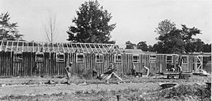
During the Great Depression (1929–1939), the Civilian Conservation Corps (CCC) helped build the park. They constructed roads, buildings, cabins, the golf course, and trails. CCC camps were set up at the park. Workers from company 1203 and later 2211 (a group of veterans) were assigned to the project. They brought sand from Sylvan Beach to create the sandy beach. They also dug basements by hand. The CCC built their own barracks and dining halls. These facilities closed in 1941. In 1988, a reunion of CCC workers was held at Green Lakes.
Wartime Use and Park Expansion
The CCC camp reopened in 1944 during World War II. It housed farm workers from Newfoundland. In 1945, it became a camp for German prisoners of war. This camp was a branch of Pine Camp, now Fort Drum. The camp closed again in 1946 when the prisoners returned to Germany.
Since 1928, the park has grown to 1,955 acres. More land was added in 1960, 1975, 1995, and 1996. In 2019, 261 more acres were acquired. Alverna Heights, a 200-acre area next to the park, was also purchased in December 2019.
In 2008, the old bathhouse near the beach was replaced. A new building was constructed for about $2.3 million. It includes changing rooms, restrooms, showers, a snack bar, and a meeting room.
Future Plans for the Park
In 2011, a "Final Master Plan" was published for Green Lakes State Park. It outlined several important points:
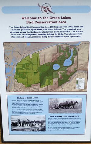
- 1,002 acres in the western part of the park are now a Bird Conservation Area.
- About 105 acres in the Old Growth area and around Round Lake are protected.
- The Rolling Hills Campground will be improved. Eventually, it will move to a new location south of the park office.
The park has a large population of white-tail deer. Some local groups have suggested bow hunting to help manage the deer. However, bow hunting is not allowed in the park.
The Amazing Geology of Green Lakes
The cliffs around Round Lake are about 150 feet high. But the rocky gorge where the lake sits is much deeper. The bottom of Round Lake is about 180 feet below its surface. Below that, there might be another 150 feet of sediment. This means nearly 500 feet of rock was carved out here!
How the Gorge Was Formed
This deep gorge was created about 15,000 years ago. This was at the end of the last ice age. A huge river of water, from melting ice sheets, flowed east through this channel. The Niagara River gorge, below Niagara Falls, is a similar example. Its depth is about 326 feet, which is shallower than Green Lakes. Other similar gorges exist nearby, like at Clark Reservation. Geologists call these areas "the Syracuse channels."
How the Lakes Were Formed
Green Lake and Round Lake are likely what's left of "plunge pools." These were formed by enormous waterfalls during the ice age. It's still a bit of a mystery why there are two separate lakes. Like plunge pools, the lakes are quite deep for their size. For example, Round Lake is 180 feet deep and about 700 feet wide.
Why the Lakes Are Blue-Green
Almost half of the water entering the lakes comes through the bedrock. This water carries many dissolved minerals. These minerals are not found in rainwater or snow. People noticed the high sulfur content in the deep waters as early as 1849. The lakes also have a lot of calcium and magnesium.
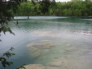
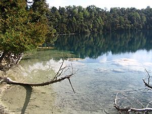
This mineral concentration causes "whiting" events each year. Tiny crystals of calcite and other minerals form and fall out of the water. During these times, the lakes look especially green. These tiny crystals settle in layers at the bottom. The unique "reef" at Deadman's Point on Green Lake was built up by this process over thousands of years. Rare aquatic mosses and sponges live beneath Deadman's Point.
Green Lakes and Climate History
Most lakes mix their deep waters with their surface waters at least once a year. But Green Lake and Round Lake are different. They are rare, meromictic lakes. This means their waters deeper than about 55 feet do not mix with the surface. Because of this, these deep waters have almost no oxygen. Instead, they are rich in calcium, magnesium, and sulfur. The lakes are meromictic because they are deep for their size and get mineral-rich groundwater.
Since there's no mixing, and no plants or animals in the deep, oxygen-free parts, the lake bottoms have undisturbed layers of sediment. These layers are like tree rings. They preserve a historical record. Scientists are using these layers to study the climate of New York over thousands of years.
 | Kyle Baker |
 | Joseph Yoakum |
 | Laura Wheeler Waring |
 | Henry Ossawa Tanner |


