Greene County, Mississippi facts for kids
Quick facts for kids
Greene County
|
|
|---|---|

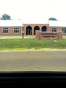
Leaksville Junior High School
|
|

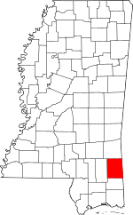
Location within the U.S. state of Mississippi
|
|
 Mississippi's location within the U.S. |
|
| Country | |
| State | |
| Founded | 1811 |
| Named for | Nathanael Greene |
| Seat | Leakesville |
| Largest town | Leakesville |
| Area | |
| • Total | 719 sq mi (1,860 km2) |
| • Land | 713 sq mi (1,850 km2) |
| • Water | 5.9 sq mi (15 km2) 0.8% |
| Population
(2020)
|
|
| • Total | 13,530 |
| • Density | 18.818/sq mi (7.266/km2) |
| Time zone | UTC−6 (Central) |
| • Summer (DST) | UTC−5 (CDT) |
| Congressional district | 4th |
Greene County is a special area called a county in the southeastern part of Mississippi. It's like a district within the state. In 2020, about 13,530 people lived here. The main town and government center is Leakesville. Greene County was created in 1811. It was named after General Nathanael Greene, a hero from the American Revolutionary War.
Contents
History
Early Inhabitants and Land Changes
Long ago, the Choctaw people were the main Native American tribe living in this area. French, Spanish, and English explorers and traders often traded with them. In 1830, the U.S. government passed the Indian Removal Act. This law forced the Choctaw and other tribes to move far away to lands west of the Mississippi River. After they left, the land was sold to new settlers from Europe.
Over time, the borders of Greene County changed many times. This happened as more people moved in and new counties were formed. Greene County, along with its neighbors Jones and Perry counties, has sandy soil. It is also known for its many pine forests. This type of land made it hard to grow many crops.
Farming and Economy
At first, the county's economy relied on farmers who grew just enough food for themselves. They also raised cattle and hogs. These animals roamed freely in the pine forests. Farmers would sell the meat to markets in Mobile, Alabama, which was the closest big city. Some farmers tried to grow cotton, but the soil wasn't very good for it. Most farms were small, and few farmers owned enslaved African Americans. In 1860, only a small number of farmers in Greene County grew cotton.
Geography
Land and Water
Greene County covers a total area of about 719 square miles. Most of this, around 713 square miles, is land. The remaining 5.9 square miles, which is less than 1%, is water.
Main Roads
You can travel through Greene County using these important highways:
 U.S. Highway 45
 U.S. Highway 98
 Mississippi Highway 42
 Mississippi Highway 57
 Mississippi Highway 63
Neighboring Counties
Greene County shares its borders with these other counties:
- Wayne County (to the north)
- Washington County, Alabama (to the northeast)
- Mobile County, Alabama (to the southeast)
- George County (to the south)
- Perry County (to the west)
Protected Natural Areas
Part of the De Soto National Forest is located within Greene County. This is a special area protected for nature and wildlife.
Demographics
Population Changes
From the 1940s to the 1960s, Greene County's population went down. During this time, many African Americans moved to the West Coast. This was part of a big movement called the Great Migration. They were looking for better job opportunities, especially in factories that made things for World War II.
Who Lives Here (2020)
According to the 2020 census, there were 13,530 people living in Greene County. Most residents identified as White (about 72.5%). About 23.23% identified as Black or African American. Other groups included Native American, Asian, Pacific Islander, and people of mixed races. About 1.26% of the population identified as Hispanic or Latino.
Communities
Towns
- Leakesville (This is the county seat, where the main government offices are.)
- McLain
- State Line (Part of this town is also in Wayne County.)
Census-Designated Places
Unincorporated Communities
These are smaller communities that are not officially towns:
Education
School District
The Greene County School District is the only school district in the county. It manages all the public schools.
Schools in the County
The schools in Greene County include:
- Greene County High School
- Greene County Vocational-Technical School
- Leakesville Elementary School
- Leakesville Junior High School
- McLain Attendance Center
- Sand Hill Attendance Center
After high school, students in Greene County can attend Jones College.
See also
 In Spanish: Condado de Greene (Misisipi) para niños

