
Griggstown, New Jersey facts for kids
Quick facts for kids
Griggstown, New Jersey
|
|
|---|---|

Griggstown Reformed Church
|
|

Griggstown, New Jersey
Location in Somerset County, New Jersey

Griggstown, New Jersey
Location in New Jersey

Griggstown, New Jersey
Location in the United States
|
|
| Country | |
| State | |
| County | Somerset |
| Township | Franklin |
| Named for | Griggs family |
| Area | |
| • Total | 2.52 sq mi (6.52 km2) |
| • Land | 2.44 sq mi (6.33 km2) |
| • Water | 0.07 sq mi (0.18 km2) 2.86% |
| Elevation | 102 ft (31 m) |
| Population
(2020)
|
|
| • Total | 835 |
| • Density | 341.51/sq mi (131.83/km2) |
| Time zone | UTC−05:00 (Eastern (EST)) |
| • Summer (DST) | UTC−04:00 (Eastern (EDT)) |
| Area code(s) | 609/640, 732/848 and 908 |
| FIPS code | 34-28470 |
| GNIS feature ID | 2583995 |
Griggstown is a small community in Franklin Township, Somerset County, New Jersey. It's known as a census-designated place (CDP), which means it's a specific area defined by the government for counting people. In 2010, about 819 people lived here. The first settlers arrived around 1733. Two important waterways, the Millstone River and the Delaware and Raritan Canal, flow right through Griggstown.
Contents
History of Griggstown
Many of the first European settlers in Griggstown came from a place called Gravesend, Brooklyn. Among them were four brothers from the Griggs family: Benjamin, Daniel, Samuel, and Thomas.
How Griggstown Got Its Name
Griggstown was named after Benjamin Griggs. He built a grist mill on the Millstone River. A grist mill is a place where grain is ground into flour. This mill became a central meeting spot for local farmers. Because of its importance, the community that grew around it was named Griggstown.
The Legend of the Griggstown Cow
For many years, from the 1970s to the early 2000s, people in Griggstown talked about seeing a wild cow. This cow was often spotted near the Delaware and Raritan Canal and the Millstone River. Some people believed it was the ghost of a cow that had been herded along the canal long ago. In 2002, a real wild bull, thought to be the famous "phantom cow," was found and rescued, but sadly, it passed away.
Geography of Griggstown
Griggstown covers about 2.5 square miles (6.5 square kilometers). Most of this area is land, with a small part being water.
Nearby Towns and Roads
Griggstown is close to several other communities, including Kingston, Rocky Hill, Montgomery Township, Kendall Park, and Franklin Park. The city of Princeton, New Jersey is also nearby.
You can reach Griggstown using major roads like Route 27 (also known as the Lincoln Highway) and County Route 518. Important local roads include Bunker Hill Road and Canal Road. There's also a small access road called the Griggstown Causeway, which has a one-lane bridge and offers a way to get in and out of the community. The D&R Canal State Park is located along this road.
Interesting Places to Visit
- Griggstown Quail Farm: A farm known for raising quail.
- Griggstown Cemetery: This cemetery is the burial place of nineteen Irish canal workers. They died from a serious illness called cholera between 1832 and 1833.
- Griggstown Volunteer Fire Company: The local fire station, run by volunteers.
- Griggstown Lock of the Delaware and Raritan Canal: A lock is a part of a canal that helps boats move between different water levels.
- Griggstown Mine
- Norseville
- Sunset Hill Garden
Griggstown Population Facts
| Historical population | |||
|---|---|---|---|
| Census | Pop. | %± | |
| 2010 | 819 | — | |
| 2020 | 835 | 2.0% | |
| Population sources: 2010 2020 |
|||
According to the 2010 United States census, Griggstown had 819 residents living in 346 households. About 230 of these were families. The population density was around 334 people per square mile.
Who Lives in Griggstown?
In 2010, most residents (about 86.8%) were White. There were also people who identified as Black or African American (2.8%), Asian (4.0%), Native American (0.2%), and other races. About 6.2% of the population identified as Hispanic or Latino.
About 25.7% of households had children under 18. Most households (57.2%) were married couples living together. The average household had 2.36 people. The median age in Griggstown was 44.9 years old.
Griggstown Historic District
|
Griggstown Historic District
|
|

Bridge Tender's House and bridge over the Delaware and Raritan Canal
|
|
| Location | Roughly Canal Road from Old Georgetown Road to Ten Mile Run |
|---|---|
| Area | 861 acres (348 ha) |
| NRHP reference No. | 84002798 |
| Significant dates | |
| Added to NRHP | August 2, 1984 |
The Griggstown Historic District is a special area that covers about 861 acres. It includes the community along Canal Road. This district was added to the National Register of Historic Places in 1984. It's important because of its history in farming, buildings, trade, industry, and transportation.
Historic Buildings in Griggstown
The district includes 68 buildings that are considered historically important.
- The Griggstown Reformed Church was built in 1843. It has a special design called Greek Revival architecture.
- Other important buildings include the Bridge Tender's House, the Bridge Tender’s Station, and the Lock Tender's House. These were all built to help operate the Delaware and Raritan Canal.
Famous People from Griggstown
Here are some notable people who have lived in or are connected to Griggstown:
- Benjamin Griggs (1690-1768): He was the founder of the grist mill that gave Griggstown its name.
- John Honeyman (1729-1822): An American spy who worked for George Washington. He gathered important information that helped Washington win the Battle of Trenton.
- Paul Muldoon (born 1951): A writer, professor, and Pulitzer Prize-winning poet. He is originally from Northern Ireland.
Gallery
-
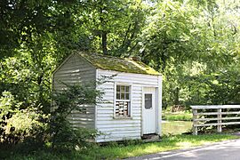
Bridge Tender’s Station
-
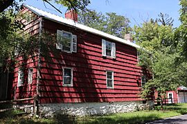
Lock Tender's House
-
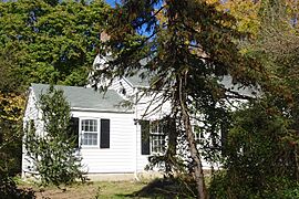
John Honeyman House
-
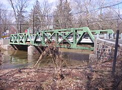
The Griggstown Causeway over the Millstone River


See also
 In Spanish: Griggstown para niños
