
Grover Beach, California facts for kids
Quick facts for kids
Grover Beach, California
|
||
|---|---|---|
| City of Grover Beach | ||

Grover Beach Welcome Sign at the corner of Hwy 1 and West Grand Ave
|
||
|
||
| Motto(s):
"A great place to spread your wings"
|
||

Location of Grover Beach in San Luis Obispo County, California.
|
||

Grover Beach, California
Location in the United States
|
||
| Country | ||
| State | ||
| County | San Luis Obispo | |
| Incorporated | December 21, 1959 | |
| Named for | D.W. Grover | |
| Government | ||
| • Type | Council–manager | |
| • Body | Grover Beach City Council | |
| Area | ||
| • Total | 2.32 sq mi (6.00 km2) | |
| • Land | 2.31 sq mi (5.99 km2) | |
| • Water | 0.00 sq mi (0.01 km2) 0.19% | |
| Elevation | 59 ft (18 m) | |
| Population
(2020)
|
||
| • Total | 12,701 | |
| • Density | 5,493.5/sq mi (2,121.1/km2) | |
| Time zone | UTC-8 (Pacific) | |
| • Summer (DST) | UTC-7 (PDT) | |
| ZIP codes |
93433, 93483
|
|
| Area code | 805 | |
| FIPS code | 06-31393 | |
| GNIS feature ID | 1652833 | |

Grover Beach is a city located in San Luis Obispo County, California, in the United States. In 2020, about 12,701 people lived there. This was a small decrease from the 13,156 people who lived there in 2010.
Grover Beach is also home to the Pacific Crossing cable Landing station. This is a special place where large submarine communications cables come out of the ocean. These cables carry internet and phone signals across the Pacific Ocean. They then connect to the communication networks in North America.
Contents
History of Grover Beach
Grover Beach was first started on August 1, 1887. It was originally called the Town of Grover. The town was named after its founder, D.W. Grover.
Mr. Grover officially registered his plans at the San Luis Obispo County Court House. The town was later known as City of Grover City. In 1959, people voted to make it an official city. This happened on December 21, 1959.
However, many people thought the name "Grover City" sounded a bit strange. They wanted a name that showed off its beautiful seaside location. So, in 1992, another vote was held. The town's name was officially changed to "Grover Beach." This new name highlights that it is a city right by the beach.
Geography and Location
Grover Beach is part of an area known as the "5 Cities Metropolitan Area." This area actually includes three cities and two other communities. The three cities are Grover Beach, Pismo Beach, and Arroyo Grande. The other communities are Oceano and Shell Beach (which is part of Pismo Beach).
The city of Grover Beach stretches from Arroyo Grande in the east all the way to Pismo State Beach. The United States Census Bureau says that Grover Beach covers about 2.3 square miles (6.0 square kilometers). Almost all of this area is land, with only a very small part being water.
Grover Beach Climate
Grover Beach has warm and dry summers. The average monthly temperature never goes above 71.6 degrees Fahrenheit (22 degrees Celsius). This type of weather is called a warm-summer Mediterranean climate. On climate maps, this is often shown as "Csb."
| Climate data for Grover Beach, California | |||||||||||||
|---|---|---|---|---|---|---|---|---|---|---|---|---|---|
| Month | Jan | Feb | Mar | Apr | May | Jun | Jul | Aug | Sep | Oct | Nov | Dec | Year |
| Mean daily maximum °F (°C) | 61.5 (16.4) |
62.3 (16.8) |
63.6 (17.6) |
66.4 (19.1) |
68.7 (20.4) |
71.1 (21.7) |
72.6 (22.6) |
74.0 (23.3) |
74.1 (23.4) |
72.1 (22.3) |
67.3 (19.6) |
61.6 (16.4) |
67.9 (19.9) |
| Mean daily minimum °F (°C) | 42.9 (6.1) |
44.3 (6.8) |
45.6 (7.6) |
46.7 (8.2) |
48.8 (9.3) |
51.8 (11.0) |
54.3 (12.4) |
54.7 (12.6) |
54.1 (12.3) |
51.1 (10.6) |
46.6 (8.1) |
42.3 (5.7) |
48.6 (9.2) |
| Average precipitation inches (mm) | 3.44 (87) |
3.53 (90) |
3.23 (82) |
1.05 (27) |
0.37 (9.4) |
0.06 (1.5) |
0.03 (0.76) |
0.02 (0.51) |
0.31 (7.9) |
0.69 (18) |
1.55 (39) |
2.47 (63) |
16.75 (426.07) |
Population and People
| Historical population | |||
|---|---|---|---|
| Census | Pop. | %± | |
| 1960 | 5,210 | — | |
| 1970 | 5,939 | 14.0% | |
| 1980 | 8,827 | 48.6% | |
| 1990 | 11,656 | 32.0% | |
| 2000 | 13,067 | 12.1% | |
| 2010 | 13,156 | 0.7% | |
| 2020 | 12,701 | −3.5% | |
| 2022 (est.) | 12,619 | −4.1% | |
| U.S. Decennial Census | |||
2010 Census Information
In 2010, the population of Grover Beach was 13,156 people. This means there were about 5,684 people living in each square mile.
Most of the people in Grover Beach were White (75.7%). Other groups included African American (1.1%), Native American (1.4%), and Asian (4.1%). About 29.2% of the people were Hispanic or Latino.
Most people (98.6%) lived in regular homes. There were 5,111 households in total. About 32.4% of these households had children under 18 living there. The average household had about 2.54 people.
The median age of people in Grover Beach was 36.9 years old. This means half the population was younger than 36.9 and half was older. About 22.3% of the population was under 18 years old.
2000 Census Information
In 2000, Grover Beach had 13,067 people living in 5,023 households. The population density was about 5,637 people per square mile.
The racial makeup was mostly White (79.75%). Other groups included African American (1.03%), Native American (1.69%), and Asian (3.75%). About 22.51% of the population was Hispanic or Latino.
About 25.6% of the people were under 18 years old. The median age was 35 years.
Transportation in Grover Beach

The Grover Beach station is the only train station in the "5 Cities" area. You can find it where Grand Avenue meets State Highway 1, right next to Pismo State Beach.
Amtrak Thruway buses also stop here. These buses connect Grover Beach to other cities. For example, you can take a bus east to Visalia or west to Santa Maria. The bus stop is now located on the west side of the train tracks, next to the station building.
The San Luis Obispo Regional Transit Authority also runs local bus lines. These buses can take you from Grover Beach to most other cities in San Luis Obispo County. They also go to Santa Maria.
Images for kids
-
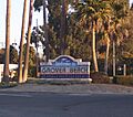
Grover Beach Welcome Sign at the corner of Hwy 1 and West Grand Ave
-

Flag of Grover Beach, California
-
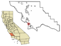
Location of Grover Beach in San Luis Obispo County, California.
-
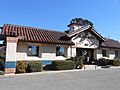
Grover Beach Amtrak Station
See also
 In Spanish: Grover Beach para niños
