
Gulf Hagas facts for kids
Quick facts for kids Gulf Hagas |
|
|---|---|

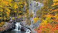
A kayaker runs "Billings Falls" in Gulf Hagas.
|
|

Gulf Hagas
Location in Maine
|
|
| Location | Northern maine |
| Established | 1985 |
| Designated: | 1968 |

Gulf Hagas is an amazing gorge located in the mountains of northern Maine. People often call it the "Grand Canyon of the East." Imagine a deep cut in the earth!
The West Branch of the Pleasant River flows through this area. Over time, it has carved a three-mile-long gorge. The walls are made of slate rock and stand very tall. You'll also find many beautiful waterfalls here. A special trail lets hikers walk along the canyon's edge. From there, you can see the waterfalls and learn about the rocks. The gorge is about 3 miles (4.8 km) long. The river drops 370 feet (110 m) as it flows through. The canyon walls can be as high as 130 feet (40 m)! Gulf Hagas is one of 14 National Natural Landmarks in Maine. This means it's a very special natural place. You can visit it during the main season, but there is a small fee.
Contents
Where is Gulf Hagas?
Gulf Hagas is part of the famous Appalachian Trail (AT) Corridor. The AT is a super long hiking trail. It stretches for 2,200 miles (3,500 km) from Georgia all the way to Maine. For a short distance, the Gulf Hagas Rim Trail actually follows the AT.
The part of the AT that goes through Gulf Hagas is called the Hundred-Mile Wilderness. This is the last 100 miles (160 km) of the AT. Many hikers think it's the most remote and challenging part. Most visitors reach Gulf Hagas by driving through Katahdin Iron Works. This is a State Park and historic site. Long ago, people used to melt iron ore here.
A Look Back: History of Gulf Hagas
Long ago, logs were floated down the gorge. These logs were used as fuel for the iron works at Katahdin Iron Works. Later, wood used to make paper was also floated through the Gulf. Some parts of the gorge were very narrow, only about 8 feet (2.4 m) wide. These narrow spots were called "the Jaws." They often caused log jams, where many logs got stuck. Log drivers, who guided the logs, used dynamite to make these spots wider. They also gave names to most of the big waterfalls and rapids in Gulf Hagas.
Paper companies like Great Northern Paper Company and Sappi used to own the Gulf. In 1969, Gulf Hagas was named a National Natural Scenic Landmark. The landowners agreed to protect about 500 acres (200 ha) of land, including the gorge. In 1985, Gulf Hagas became part of the Appalachian Trail Corridor. This means the National Park Service now owns it. The Maine Appalachian Trail Club, mostly made up of volunteers, helps take care of the trails.
How Gulf Hagas Was Formed
The main rock that makes up Gulf Hagas is called slate. It's part of a rock layer known as the Carrabassett formation. About 400 million years ago, huge pieces of the Earth's crust pushed together. This forced land upward and made the ancient Iapetus Ocean disappear. Mud deposits were left behind. Over time, this mud was heated, squeezed, and changed into slate.
Slate breaks with sharp, jagged edges. But the constant movement of water and small rocks in the gorge has made the walls smooth and straight. The swirling water and pebbles also create round holes in the rock called potholes. Scientists think Gulf Hagas might have been formed at the end of the last ice age. A huge lake, held back by ice, may have burst. This would have sent a massive amount of water through the area, carving out the Gulf.
Plants and Animals of Gulf Hagas
The Gulf Hagas Rim Trail goes through a special area called The Hermitage. This is one of the few remaining old-growth forests in New England. These are forests that have never been cut down by people. Here, you can see giant eastern white pine trees. Some are as tall as 150 feet (46 m) and can be 10 feet (3.0 m) wide!
Other common trees along the rim trail include black spruce, eastern hemlock, and balsam fir. You might also spot some amazing animals. Moose are often seen in the area. You could also see white-tailed deer and snowshoe hare. Inside the gorge, brook trout are very common in the water.
Myths and Legends of the Gulf

Native Americans definitely lived, hunted, and fished around Gulf Hagas a long time ago. Gravesites belonging to a group called the "Red Paint People" have been found here. These people used red ochre, a type of iron ore found in the area. They used it on their tools, their skin, and during burials. They would line graves with red ochre, which helped preserve the bodies. Some of these burial grounds are as old as 7,500 years!
There's also a legend about a man named Simon Garew. He was known as the "Legend of the Gulf." Every year, he would travel to the gorge with his dog to hunt and fish. A poem called Simon Garfew A Legend of Gulf Glen tells us his secret reason for visiting:
-
-
-
- "The Great Spirit comes to the face in the rock,
- The moon when the leaves grow red;
- And when the round moon shines upon it,
- Shines into the Gulf at night,
- Shines full and fair upon it, Making it plain and white, -
- Whoever waits there, with fasting,
- Below the strong face,
- With a deer's blood for offering
- Always finds pardon and peace."
-
-
One fall, Simon went into the canyon during a storm. The gorge filled with water, and he was never seen again. Only his loyal dog was left, waiting for him at the Gulf.
Hiking Adventures
Hiking along the Gulf Hagas Rim Trail is the most popular way to see the gorge. Hikers should be ready for a challenge. The hike is about 8 miles (13 km) long and can take up to 8 hours. It's a good idea to start early in the day. If you want an easier hike, you can visit The Hermitage and Gulf Hagas Brook. This is a 4 miles (6.4 km) round trip.
You cannot camp in Gulf Hagas itself. However, camping is available nearby through KI Jo-Mary. Fires are not allowed in Gulf Hagas. You might find water along the Rim Trail, but you should always treat it before drinking. Remember to take everything you bring into Gulf Hagas back out with you. This is a natural area with no trash services. In spring and summer, there can be many black-flies and mosquitoes. It's smart to use insect repellent and wear long sleeves. Maine weather can change quickly, so be ready for any kind of weather.
Hiking the Rim Trail
When you start your hike, follow the signs from the parking lot to the trail-head. You'll quickly reach the West Branch of the Pleasant River. There isn't a bridge here, so you'll need to walk across the river. In summer, the water is usually low and easy to cross. But if it's spring or after a big rain, the water might be too high. If the river is unsafe, you can drive about 6 miles (9.7 km) up Katahdin Iron Works Road. From there, you can hike in from the "Head of the Gulf," where there is a bridge.
The trail meets the Appalachian Trail (AT) just before the river crossing. Walk about a tenth of a mile, and the trail will split. Stay left to enter The Hermitage. This is an old-growth forest with huge White Pine trees. After about a mile of easy walking, you'll reach the Rim Trail Loop. The Appalachian Trail goes to the right, and another trail goes straight. This straight trail is the Tote Road. Many people use this trail for their return trip because it's easier to walk.
To follow the Gulf Hagas Rim Trail, stay left. You'll immediately cross the pretty Gulf Hagas Brook. Then you'll reach the gorge itself. The Rim Trail has many viewpoints where you can see the waterfalls and rapids below. Some famous spots include Jaws, Buttermilk Falls, and Billings Falls. The 20-foot (6.1 m) high Billings Falls is a highlight of the hike. After Billings Falls, you'll be close to the Tote Road for your return. Once you reach the Tote Road, turn right and stay on it until you get back to the AT. This completes the 5 miles (8.0 km) loop. Then, return along the same trail through The Hermitage.
Kayaking the Gulf

Kayaking in Gulf Hagas is best for expert, class five, whitewater kayakers. The steep walls of the gorge can make it very hard to get out of the water. Many kayakers think Gulf Hagas has the best creek run in Maine. The whitewater here is special and high quality. Deep gorges and waterfalls are not common in Maine. Great views, good water levels for kayaking, and waterfalls make Gulf Hagas a classic spot for expert kayakers.
Other Fun Activities
Hunting is allowed in the KI Jo-Mary area, but not on the trails inside Gulf Hagas. Fishing is allowed, following Maine State laws. ATVs (all-terrain vehicles) are not allowed in KI Jo-Mary.
How to Get There
The roads leading to Gulf Hagas are on private land. A group of private landowners called KI Jo-Mary manages these roads. They collect fees to help maintain the roads and facilities. The gate fee is $10 for Maine residents and $20 for non-Maine residents. The gate is open from 6 AM to 9 PM. The gatehouse is open from May through October. During the off-season, no fees are collected, and the gate stays open. Camping is also available for a fee.
If you're driving from the south, once you reach Brownville, keep going north on Route 11 for about 8.1 miles (13.0 km). Then, turn slightly left onto the dirt Katahdin Iron Works Road. Drive for about 6.5 miles (10.5 km) until you reach the gatehouse. Stop here and pay the fee. Cross the West Pleasant River using the bridge and turn right right away. Stay left at the next three intersections and drive for about 6.5 miles (10.5 km). You'll see a parking area on the right where the trailhead is located.
If you're coming from the north, from Greenville, follow Pleasant Street for half a mile onto E Road. Travel on E Road for about 3.6 miles (5.8 km), which then turns into Ki Road. Follow Ki Road for about 8 miles (13 km). Turn right onto Katahdin Iron Works Road and drive for about 6.1 miles (9.8 km) until you reach the trailhead. Gate fees will also be collected if you come from Greenville.
Images for kids
-
Fall foliage overlooking Buttermilk Falls in Gulf Hagas on an overcast October day in 2016.

