
Brownville, Maine facts for kids
Quick facts for kids
Brownville, Maine
|
|
|---|---|

General view c. 1910
|
|

Location in Piscataquis County and the state of Maine.
|
|
| Country | United States |
| State | Maine |
| County | Piscataquis |
| Incorporated | 1824 |
| Communities | Brownville Brownville Junction Knights Landing |
| Government | |
| • Type | Board of Selectmen |
| Area | |
| • Total | 44.62 sq mi (115.57 km2) |
| • Land | 44.03 sq mi (114.04 km2) |
| • Water | 0.59 sq mi (1.53 km2) |
| Elevation | 781 ft (238 m) |
| Population
(2020)
|
|
| • Total | 1,139 |
| • Density | 26/sq mi (10.0/km2) |
| Time zone | UTC-5 (Eastern (EST)) |
| • Summer (DST) | UTC-4 (EDT) |
| ZIP codes |
04414, 04481
|
| Area code(s) | 207 |
| FIPS code | 23-08325 |
| GNIS feature ID | 0582374 |
Brownville is a small and friendly town located in Piscataquis County, Maine, in the United States. In 2020, about 1,139 people lived here. The town includes a few smaller areas like Brownville, Knight's Landing, and Brownville Junction. Close to Brownville Junction, you can find part of the famous Appalachian Trail, known as the 100-Mile Wilderness.
Contents
Brownville's Past: A Look at History
How Brownville Began
The land where Brownville now stands was once bought by Moses Brown and Major Josiah Hill. They were from Newburyport, Massachusetts. In 1806, these early settlers built a dam and watermills on the Pleasant River. A dam helps control water flow, and watermills used the river's power to grind grain or saw wood.
At first, the area was called township T5 R8 NWP. In 1819, it became Brownville Plantation. It was named after Francis Brown, who was Moses Brown's nephew. He owned mills and traded goods. Finally, in 1824, the community officially became a town and was named Brownville.
Early Life and Industries
When people first settled in Brownville, they were given about 50 acres of land. They had to clear this land and farm it. They grew crops like hay, oats, potatoes, wheat, and various vegetables.
The water power from the Pleasant River was very important. It helped power many businesses. There were sawmills that cut wood, mills that made clapboard (a type of siding for houses), and gristmills that ground grain into flour. Factories also made shovel handles and carriages.
Slate and Iron Mining
Brownville was also known for its rich natural resources. There were many quarries where people dug up slate. Slate is a type of rock used for roofing tiles and blackboards. The slate from Brownville was so good that it won first prize at a big exhibition in 1876!
The Bangor & Piscataquis Slate Company opened in 1843 and had 60 workers. They produced a lot of roofing slate each year. Another big quarry, the Merrill Quarry, opened in 1846. It had about 80 workers and produced even more slate. Some quarries even brought in Welsh workers because they were skilled in slate mining. The last slate quarry closed in 1917.
Iron ore was also found near a place called Ore Mountain. In 1843, the Katahdin Iron Works was built. This was a factory where iron was made. Roads were built, and a blast furnace was set up to melt the iron ore. A hotel and houses were built for the workers. They used a lot of wood to make charcoal for the furnace. The iron works operated until 1856, producing thousands of tons of iron.
The Railroads Arrive
Moving the iron to places like Bangor was difficult and expensive. So, in 1881, the Bangor and Katahdin Iron Works Railway (B&KIW) was built to Brownville. It later connected to the Katahdin Iron Works in 1883.
In 1889, another important railway, the International Railway of Maine, was built by the Canadian Pacific Railway (CPR). This line connected Montreal, Quebec, to Saint John, New Brunswick. It passed about three miles north of Brownville and crossed the B&KIW line. This crossing point became known as Brownville Junction.
Over the years, these railway lines changed hands. Today, the Canadian Pacific Railway owns them again. This helps connect Brownville Junction to the Port of Saint John in New Brunswick.
Local History Buff
A local historian named Bill Sawtell has written many books about Brownville's history. He has shared stories about the Katahdin Iron Works, the Highland Quarry, and the Bangor and Aroostook Railroad.
-
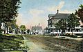
Street scene in 1910
-

Community Church c. 1905
-
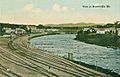
B. & A. R. R. yard c. 1912


Brownville's Location and Climate
Where is Brownville?
Brownville covers an area of about 44.62 square miles (115.57 square kilometers). Most of this area is land, with a small part being water. The town is located between Sebec Lake and Schoodic Lake. The Pleasant River flows through Brownville.
Brownville's Weather
Brownville has a type of weather called a humid continental climate. This means it has big differences in temperature throughout the year. Summers are usually warm to hot, and sometimes humid. Winters are cold, and can sometimes be very cold.
Brownville's Population Over Time
| Historical population | |||
|---|---|---|---|
| Census | Pop. | %± | |
| 1830 | 402 | — | |
| 1840 | 568 | 41.3% | |
| 1850 | 787 | 38.6% | |
| 1860 | 793 | 0.8% | |
| 1870 | 860 | 8.4% | |
| 1880 | 896 | 4.2% | |
| 1890 | 1,074 | 19.9% | |
| 1900 | 1,570 | 46.2% | |
| 1910 | 1,808 | 15.2% | |
| 1920 | 1,743 | −3.6% | |
| 1930 | 1,910 | 9.6% | |
| 1940 | 1,914 | 0.2% | |
| 1950 | 1,964 | 2.6% | |
| 1960 | 1,641 | −16.4% | |
| 1970 | 1,490 | −9.2% | |
| 1980 | 1,545 | 3.7% | |
| 1990 | 1,506 | −2.5% | |
| 2000 | 1,259 | −16.4% | |
| 2010 | 1,250 | −0.7% | |
| 2020 | 1,139 | −8.9% | |
| U.S. Decennial Census | |||
People in Brownville
According to the census in 2010, there were 1,250 people living in Brownville. These people lived in 527 households. Most of the people living in Brownville were White (97.3%).
About 29.4% of the households had children under 18 years old. The average household had about 2.37 people. The average age of people in Brownville was 44.5 years old. About 22.7% of the residents were under 18, and 17.4% were 65 or older.
See also
 In Spanish: Brownville (Maine) para niños
