Gulgibarra facts for kids
The Gulgibarra (also known as gulgibara or koolgibbera) are an Aboriginal Australian group. They are strongly connected to the sandy coastlines and the lower, salty parts of the Mulgrave and Russell Rivers. This area is also called Madjaybana. It includes the Mutchero Inlet in North East Queensland's wet tropics, where the water flows through sand.
Contents
Who are the Gulgibarra?
A local Aboriginal language speaker named Djariyi (also known as Dick Moses) told a linguist named Robert M. W. Dixon that he was a member of the Gulgibarra group.
Djariyi and other local language speakers taught Dixon that the original people of the Yarrabah-Cairns area are called bama. They belong to different local groups. Each person can identify their group by adding barra (meaning 'belonging to') to a word for the land they are connected to. This connection comes from their birth, life, and history. For example, Djariyi added barra to gulgi (meaning 'sand'). This is how he identified his group as Gulgibarra, which means 'belonging to the sand'.
Other local groups living near the Gulgibarra include:
- The Malanbarra: This means 'belonging to large flat rock'. They are from the freshwater upper parts of the Mulgrave River. Here, the river flows over smooth, flat rocks.
- The Jinggabarra: This means 'belonging to water spray'. They are from the fast-flowing freshwaters of Wooroonooran National Park's Behana Gorge. This water flows into the Mulgrave River to the north-west.
- The Bindabarra: This means 'belonging to shoulder'. They are from the freshwater waterfalls flowing through Wooroonooran National Park's Babinda Boulders. This water flows into the Russell River to the south-west.
- The Bagirgabarra: This group is named after bagirram, which is a type of tree called water gum. They live along the coast and flatter wetlands to the south, down to the North Johnstone River.
The Madjay Language
Dixon's research shows that the Gulgibarra area, with its sandy coastlines and lower river parts, once mainly spoke a language called Madjay. This language was supposedly named madjay because that was their word for 'spear'. Madjay is part of the Yidinyic language family.
Dixon found that there are no old records from the 1800s or early 1900s showing Madjay being spoken. However, Djariyi, the Gulgibarra language speaker, spoke a special coastal version of the Yidinyic language. Other versions were spoken in different areas:
- A Gungay version was spoken on the Yarrabah headland to the east.
- A Wanyur version was spoken on the coast to the south.
- A tablelands version was spoken in the mountains to the west.
Aboriginal elders and families who identify as "Madjay" language owners say that Gulgibarra is one of the important 'ancestral estates' where Madjay was spoken. This area is part of what they call Madjandji country. They have even created a booklet. It lists the language names for some important local minya (meaning 'edible meat') and mayi (meaning 'edible plant') found in the Gulgibarra area. These include words for flying fox, southern cassowary, echidna, wild berry, burdekin plum, and wild ginger.
First Encounters with Europeans
The Mulgrave and Russell Rivers were given their Queensland names by an early explorer, George Elphinstone Dalrymple. This happened on November 18, 1873, during his expedition along the North-East Coast of Queensland. As Dalrymple and his group explored the lower parts of these rivers, they were traveling among the Gulgibarra people. His group included a botanist, Sub-inspector Johnstone, and 10 mounted native police. Dalrymple reported that "the blacks here are numerous but peaceable; they "cooey" to us occasionally".
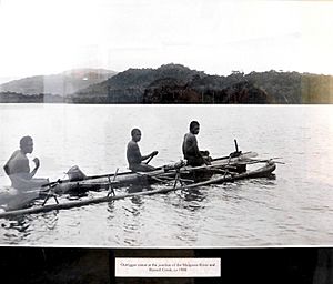
Dalrymple wrote about the Gulgibarra people. He described their 'neat' and 'picturesque' round-topped palm-leaf shelters, called guyahs. He also saw smoke from their camps rising from the treetops behind them. He observed them using rafts and canoes to cross the river. They were also fishing in outrigger canoes, which were well-equipped with fish spears, lines, and nets. Dalrymple wrote:
"..in the dark, we passed close to numerous large fires of a blacks’ camp, blazing brilliantly on the river bank under the dark forest, giving, with the ruddy reflection in the broad river, the glow and dark shades of the surrounding jungle, combined with the loud yells with which we were hailed from the dense thickets as we passed, a wild and picturesque effect. Visiting the camp, then deserted, a few days later, we found that they had been feasting upon a large crocodile..".
At the entrance to the salty lower parts of the Mulgrave and Russell Rivers, there are two sandy points. These points reach into the shared river mouth, known as Mutchero Inlet. The northern point is called 'Flirt Point', and the southern point is 'Point Constantine'.
Later, in 1889, a colonial botanist named Frederick Manson Bailey met the Gulgibarra (who he spelled koolgibberah). He was collecting plants for a Queensland Government Botanical Expedition. He found that the Gulgibarra crushed and used an unnamed type of vine along the Mulgrave River. They used it to stun fish in the river's freshwater lagoons. Bailey named this vine species Derris koolgiberrah, which helped to keep the Gulgibarra name alive in the plant's scientific name.
Local Stories and Lore
In 2008, a local Aboriginal elder named Murrai (also known as Annie Wonga) and her friends shared some local lore. These are ancestral stories that have been passed down for a very long time. They tell stories about the lower Mulgrave and Russell River areas, including the Gulgibarra land.
 | Claudette Colvin |
 | Myrlie Evers-Williams |
 | Alberta Odell Jones |


