
Babinda Boulders facts for kids
Quick facts for kids Boulders Scenic ReserveQueensland |
|
|---|---|

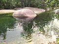
The main swimming hole at Babinda Boulders
|
|

Boulders Scenic Reserve
Location in Queensland
|
|
| Nearest town or city | Babinda |
| Managing authorities | Cairns Regional Council |
| Website | Boulders Scenic Reserve |
The Boulders Scenic Reserve, often called Babinda Boulders or just the Boulders, is a popular spot for outdoor fun. It's managed by the Cairns Regional Council and is right next to the Wooroonooran National Park in far north Queensland, Australia. It's a great place for families to visit and enjoy nature.
Contents
About the Boulders Scenic Reserve
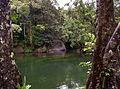
The Boulders Scenic Reserve covers a part of Babinda Creek. This is where several smaller streams join the main creek. Most of the area is covered in thick, green rainforest. Only the picnic and play areas near the main swimming hole are cleared.
The reserve is located in the foothills between Queensland's two tallest mountains. These are Mount Bartle Frere and Mount Bellenden Ker. This high mountain range, along with the tropical weather, makes this coastal area very wet. In fact, the strip between Tully and Cape Tribulation gets the most rain in all of Australia! This means there's always plenty of cool, fresh mountain water flowing through the creeks in the reserve.
Where to Find the Boulders
You can get to the Boulders Scenic Reserve by going through the town of Babinda. Babinda is about 60 km (37 mi) south of Cairns. It's also about 30 km (19 mi) north of Innisfail on the Bruce Highway. The reserve itself is located about 6 km (4 mi) to the west of Babinda town.
Things to Do and See
This place is perfect for families! It has clear, cool swimming holes that are safe and calm all year. There's a picnic area with tables and free gas barbecues. You'll find clean toilets and showers too. Kids can enjoy swings and grassy areas. There are also special viewing platforms and walking paths. A free camping ground is available nearby if you want to stay longer.
Walking Tracks
.jpg)
There are three fun walking tracks at the Boulders Reserve:
- Wonga Circuit Track: This is an easy 850 m (0.5 mi) loop walk. It takes you through the rainforest alongside both North Babinda Creek and Babinda Creek.
- Devil's Pool Walk: This 1.2 km (0.7 mi) return walk follows a lower section of Babinda Creek. There are two viewing platforms where you can see the amazing rock formations.
- Goldfield Trail: This track is for more serious walkers. It starts from the reserve and goes north-west for about 19 km (12 mi). It crosses a saddle in the Bellenden Ker Range to the Goldsborough Valley.
Local Indigenous Names
The local Yidinji people have their own names for this area. In their language, the area is called Bunna Binda. This means "waterfall" or "water over your shoulder". The town name "Babinda" comes from this indigenous name. Wonga is a local indigenous family name. The original Yidinji name for Mt Bartle Frere is Chooreechillum.
The Devil's Pool
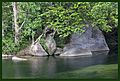
The Devil's Pool is a very dangerous part of Babinda Creek. It's about 700 m (766 yd) downstream from the main swimming hole. Here, the river valley becomes very narrow. The creek channel is filled with huge boulders and lined with smooth bedrock. These rocks have been polished smooth by the water flowing over them for thousands of years.
In the dry season, the water in Babinda Creek flows over and under these rocks. Sometimes it even disappears from view. In the wet season, the boulders are often completely covered by water. No matter the season, the rocks are extremely slippery when wet. The strong current can also be very powerful. For safety, it is important to stay on the viewing platforms and not enter the water in this area.
Images for kids
-
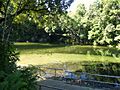
The main swimming hole at the Boulders Scenic Reserve, Babinda, Queensland
-
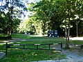
Babinda boulders picnic area
-
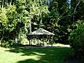
A picnic shelter at Babinda Boulders
-
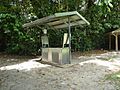
One of the public barbeques at Babinda Boulders Scenic Reserve
-
Swimming in Babinda Creek, upstream from the main recreation area
-
The Boulders main swimming hole
-
The main swimming hole
-
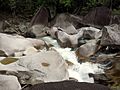
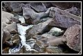
Water rushing between boulders from the Devil's Pool
-
Babinda Creek below the Devil's Pool


.jpg)


.jpg)
