
Babinda facts for kids
Quick facts for kids BabindaCairns, Queensland |
|||||||||||||||
|---|---|---|---|---|---|---|---|---|---|---|---|---|---|---|---|

Babinda on a typical rainy day
|
|||||||||||||||

Babinda
Location in Queensland
|
|||||||||||||||
| Established | circa 1880 - circa 1900 | ||||||||||||||
| Postcode(s) | 4861 | ||||||||||||||
| Elevation | 18.3 m (60 ft) | ||||||||||||||
| Area | 39.9 km2 (15.4 sq mi) | ||||||||||||||
| Time zone | AEST (UTC+10:00) | ||||||||||||||
| Location |
|
||||||||||||||
| LGA(s) | Cairns Region | ||||||||||||||
| State electorate(s) | Hill | ||||||||||||||
| Federal Division(s) | Kennedy | ||||||||||||||
|
|||||||||||||||
|
|||||||||||||||
Babinda is a small town in Queensland, Australia, located in the Cairns Region. It's south of Cairns and used to be known as a "sugar town" because of its big sugar mill.
Babinda is famous for being one of the wettest towns in Australia! It often competes with another town, Tully, for the 'Golden Gumboot' award, which goes to the town with the most rain. Babinda usually wins, getting over 4,279.4 millimetres (168.48 in) of rain every year! In 2021, about 1,287 people lived in Babinda.
Contents
- Exploring Babinda's Location
- Babinda's Story: A Look Back in Time
- People of Babinda
- Historic Places to See
- Local News and Education
- Community Services and Fun Places
- Emergency Services and Health Care
- Exciting Events in Babinda
- Places to Visit and Explore
- Getting Around Babinda
- Babinda's Unique Climate
- Famous People from Babinda
- Images for kids
Exploring Babinda's Location
Babinda is about 59.1 kilometres (36.7 mi) south of Cairns.
Mountains and Transport
The town is very close to Queensland's two tallest mountains: Mount Bartle Frere (the highest peak in Queensland!) and Mount Bellenden Ker.
The main road, the Bruce Highway, runs right through Babinda. The North Coast railway line also passes through the town. Babinda has its own railway station, making it easy to travel to and from the town.
Babinda's Story: A Look Back in Time
The name Babinda comes from an Indigenous Australian language. Some say it means "mountain," while others believe it's a Yidinji word for "water," which makes sense given how much rain the area gets!
The Sugar Town Era
Babinda became a busy place when work began on a sugar mill in 1914. This mill was a huge part of the town's life.
- The Babinda Sugar Mill officially opened on 15 September 1915.
- It was the main source of jobs and money for the area. People even called it the "lifeblood of the town."
- Sadly, the mill closed on 23 February 2011.
Schools and Community Buildings
- Babinda State School first opened on 4 November 1914. It started in temporary buildings.
- In 1963, the school began teaching high school students up to Year 10.
- The school moved to its current location in 1969 and later expanded to teach students up to Year 12 in 1983.
- The Babinda Post Office opened around 1915.
- Churches were also built, including a Presbyterian church in 1916 and a Catholic church in 1917.
Facing Challenges: Cyclones
Babinda has faced tough times. On 10 March 1918, a powerful cyclone hit the town. It caused a lot of damage, with some reports saying almost every building was affected. Even a train at the station was blown over! Both the Presbyterian and Catholic churches were destroyed. But the community worked together to rebuild them.
Another strong cyclone, Cyclone Larry, hit Babinda in March 2006, damaging many buildings.
St Rita's Catholic School
- In 1924, people started raising money for a Catholic school.
- Sisters of Mercy opened St Rita's Catholic primary school on 25 January 1926, with 34 students.
- A new brick school building was opened in 1945.
- For a short time, from 1948 to 1951, the school also offered secondary schooling.
Remembering History
The Babinda War Memorial was officially revealed on 25 April 1927. It helps the community remember those who served in wars.
People of Babinda
In 2021, the town of Babinda had a population of 1,287 people. The community is a mix of different backgrounds, with most residents being from Australia.
Historic Places to See
Babinda has some special places that are protected because of their history:
- Babinda State Hotel, on Munro Street
- Babinda Air Raid Shelter, also on Munro Street
Local News and Education
If you want to know what's happening in Babinda, you can read the local newspapers, The Cairns Post or the Wet Tropic Times.
Schools in Babinda
- St Rita's School is a Catholic primary school for students from Prep to Year 6. It's located on Church Street.
- Babinda State School is a government school that teaches students from Prep all the way to Year 12. You can find it on Boulders Road. It also has a special education program.
- For younger children, there's Babinda Kindergarten on Church Street and Babinda Early Learning on Pollard Road.
Community Services and Fun Places
Community Hubs
- The Cairns Regional Council runs a public library in Babinda at 24 Munro Street.
- The Queensland Country Women's Association (QCWA) has a hall on King Street where they meet.
- St Rita's Catholic Church is on Church Street.
Sports and Entertainment
- The Babinda Bowls Club is a great place for lawn bowls, located on Munro Street.
- The Babinda Munro Picture Theatre is a beautifully restored old movie theatre on Munro Street where you can catch a film.
Emergency Services and Health Care
Babinda has important services to keep everyone safe and healthy:
- Babinda Police Station
- Babinda Fire Station
- Babinda SES Facility (for help during emergencies like floods or storms)
The Babinda Multi Purpose Health Centre is a public hospital with 22 beds and an emergency department. The Babinda Ambulance Station is also located at the hospital.
There are two cemeteries in Babinda, managed by the Cairns Regional Council: the Old Babinda Cemetery and the New Babinda Cemetery.
Exciting Events in Babinda
Babinda has many community events. The annual Harvest Festival is celebrated in October. It's a unique festival that includes fun and unusual events like the Sugar Bowl competition, the Gumboot Toss, and the Umbrella Toss. These events celebrate Babinda's connection to the sugar industry and its very wet weather! The festival has been running since the 1960s.
Places to Visit and Explore

- The Babinda War Memorial is in Anzac Park on Munro Street. It's a place to remember and honor those who served.
- The Boulders and Devil's Pool are popular natural attractions. There's a nice picnic area nearby next to Babinda Creek.
- Babinda Rotary Park on Howard Kennedy Drive offers free camping for up to three days.
Getting Around Babinda
Babinda is located right on the Bruce Highway, which is a major road. The town also has a railway station. You can catch long-distance trains like the Spirit of Queensland from here, but you need to book in advance for the train to stop.
Babinda's Unique Climate
Babinda has a tropical rainforest climate with very humid and consistently wet weather. It's famous for being the wettest town in Australia, with an average of 4,279.4 millimetres (168.48 in) of rain each year. It's not unusual for some months, especially between January and April, to have over 1,000 millimetres (39 in) of rain! Sometimes, whole months can go by without a single sunny day.
Wet and Dry Seasons
- The wet season runs from December to May. During this time, heavy monsoonal downpours happen almost every day. Sometimes, even heavier rain comes from tropical storms or cyclones.
- The dry season is from June to November. Even then, Babinda still gets over 100 millimetres (3.9 in) of rain a month! This rain usually comes as coastal showers, which can be light or very heavy.
- From October to December, thunderstorms with dangerous lightning and strong winds can be a threat.
| Climate data for Babinda Post Office | |||||||||||||
|---|---|---|---|---|---|---|---|---|---|---|---|---|---|
| Month | Jan | Feb | Mar | Apr | May | Jun | Jul | Aug | Sep | Oct | Nov | Dec | Year |
| Mean daily maximum °C (°F) | 30.6 (87.1) |
30.4 (86.7) |
29.5 (85.1) |
28.0 (82.4) |
26.1 (79.0) |
24.3 (75.7) |
23.8 (74.8) |
24.9 (76.8) |
26.5 (79.7) |
28.0 (82.4) |
29.4 (84.9) |
30.4 (86.7) |
27.7 (81.8) |
| Mean daily minimum °C (°F) | 23.2 (73.8) |
23.3 (73.9) |
22.5 (72.5) |
21.0 (69.8) |
19.0 (66.2) |
16.7 (62.1) |
15.7 (60.3) |
16.2 (61.2) |
17.6 (63.7) |
19.6 (67.3) |
21.5 (70.7) |
22.7 (72.9) |
19.9 (67.9) |
| Average precipitation mm (inches) | 644.9 (25.39) |
744.9 (29.33) |
801.0 (31.54) |
535.1 (21.07) |
348.2 (13.71) |
202.1 (7.96) |
143.9 (5.67) |
113.2 (4.46) |
123.5 (4.86) |
125.1 (4.93) |
190.6 (7.50) |
306.9 (12.08) |
4,279.4 (168.5) |
| Source: bom.gov.au | |||||||||||||
Famous People from Babinda
- Sharyn Ghidella, a well-known journalist and news presenter, was born in Babinda.
Images for kids
-
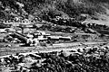
Babinda Sugar Mill from above, around 1964
-
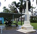
World War 1 memorial in Babinda, 2006


