Guluguba, Queensland facts for kids
Quick facts for kids GulugubaQueensland |
|||||||||||||||
|---|---|---|---|---|---|---|---|---|---|---|---|---|---|---|---|

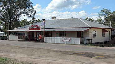
Cafe at Guluguba on the Leichhardt Highway, 2014
|
|||||||||||||||
| Population | 86 (2021 census) | ||||||||||||||
| • Density | 0.2219/km2 (0.575/sq mi) | ||||||||||||||
| Postcode(s) | 4418 | ||||||||||||||
| Area | 387.6 km2 (149.7 sq mi) | ||||||||||||||
| Time zone | AEST (UTC+10:00) | ||||||||||||||
| Location | |||||||||||||||
| LGA(s) | Western Downs Region | ||||||||||||||
| State electorate(s) | Callide | ||||||||||||||
| Federal Division(s) | Maranoa | ||||||||||||||
|
|||||||||||||||
Guluguba is a small country town in Queensland, Australia. It's located in the Western Downs Region. In 2021, only 86 people lived there, making it a very quiet place!
Contents
Where is Guluguba?
Guluguba is found along the Leichhardt Highway. It's north of a town called Miles and south of Wandoan.
Old Railway Lines
A railway line, now closed, used to run through Guluguba. The town had its own train station, called Guluguba railway station. There was also another station, Giligulgul railway station, further south.
Guluguba's Past
The name Guluguba comes from an Aboriginal word. It is believed to mean squatter pigeon, which is a type of bird.
Early Services
- A post office opened in Guluguba by 1916. Before that, there was a smaller "receiving office" from 1915.
- The first school, Guluguba Provisional School, opened on February 1, 1917.
- At first, it shared a teacher with Downfall Creek Provisional School.
- When Downfall Creek school closed in 1918, Guluguba became a full-time school.
The Railway Arrives
The Wandoan railway line was built in stages.
- The first part, from Miles to Giligulgul railway station, opened on December 20, 1913.
- The second part, which included Guluguba railway station, opened on December 16, 1914.
Community and Church
In 1931, a group of German settlers opened St John's Lutheran church. They had moved from South Australia.
School Challenges
- In 1940, the local Lutheran community started a Lutheran Day School at Downfall Creek.
- Guluguba State School had to close twice, in 1942 and 1944. This happened because there wasn't enough housing for teachers.
- In 1957, the Queensland Education Department agreed to provide a teacher for Downfall Creek. So, the Lutheran Church school became Downfall Creek Provisional School again. It finally closed in 1962.
Who Lives in Guluguba?
The number of people living in Guluguba has changed over the years.
- In 2011, Guluguba and its neighbour Wandoan had a combined population of 655 people.
- By 2016, Guluguba alone had 109 people.
- In 2021, the population was 86 people.
Learning in Guluguba
Guluguba State School is a primary school for kids from Prep to Year 6. It's located on Fosters Road.
- In 2016, the school had 6 students and 2 teachers.
- By 2018, the number of students grew to 13.
High School Options
There are no high schools directly in Guluguba.
- For students up to Year 10, the closest government high school is Wandoan State School in Wandoan.
- For students up to Year 12, Miles State High School in Miles is the nearest option.
Places to Visit
St John's Lutheran Church, also known as the Downfall Creek Lutheran Church, is located at 654 Upper Downfall Creek Road.
Famous People from Guluguba
- Deb Frecklington is a well-known person who attended Guluguba State School. She used to be a leader of the Liberal National Party in Queensland's parliament.
 | Bessie Coleman |
 | Spann Watson |
 | Jill E. Brown |
 | Sherman W. White |


