Wandoan facts for kids
Quick facts for kids WandoanQueensland |
|||||||||||||||
|---|---|---|---|---|---|---|---|---|---|---|---|---|---|---|---|
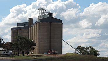
Grain silos in 2014
|
|||||||||||||||
| Population | 666 (2021 census) | ||||||||||||||
| • Density | 0.8145/km2 (2.110/sq mi) | ||||||||||||||
| Postcode(s) | 4419 | ||||||||||||||
| Area | 817.7 km2 (315.7 sq mi) | ||||||||||||||
| Location | |||||||||||||||
| LGA(s) | Western Downs Region | ||||||||||||||
| State electorate(s) | Callide | ||||||||||||||
| Federal Division(s) | Maranoa | ||||||||||||||
|
|||||||||||||||
Wandoan is a town and area in the Western Downs Region of Queensland, Australia. It used to be called Juandah. The town is located on the Leichhardt Highway, about halfway between Taroom and Miles. It is a main hub for the local cattle farming industry. In 2021, Wandoan had a population of 666 people.
Contents
History of Wandoan
The town of Wandoan started in 1849. This was when a large property called 'Juandah' Station was set up. It was a huge area of land, covering about 449 square miles (1,160 square kilometres).
In 1857, there were conflicts between settlers and Aboriginal people in the area. After a serious event at Hornet Bank, some Aboriginal people were brought to Juandah. Even though a group of magistrates said they were not involved, some local settlers harmed them. Two Aboriginal people were kept to bury the others. One of them was then harmed, and the other was allowed to leave.
A small hotel was built in the 1890s. By the end of the 19th century, the hotel was popular and a small town began to form around it.
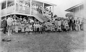
Juandah Provisional School opened its doors on October 30, 1911. It became a State School in 1916. The school closed for a short time in 1922 due to low student numbers. It reopened in 1923 and was renamed Wandoan State School in 1924. A section for older students was added in 1961.
The railway line connecting Wandoan to Miles opened on December 16, 1914.
In 1926, Juandah was officially renamed Wandoan. This was done to avoid confusion with another town called Jundah near Longreach.
After World War II, land around Wandoan was given to soldiers who had returned from the war. This happened through a special process in the 1950s.
The Wandoan Library first opened in 1987.
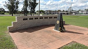
The Wandoan War Memorial is located on Henderson Street. It honors Australians who served in all wars. There are special plaques for different wars on the wall behind the memorial. It was officially opened on Anzac Day, April 25, 1993.
Population of Wandoan
The number of people living in Wandoan has changed over the years:
| Year | Population |
|---|---|
| 2001 | 401 |
| 2006 | 386 |
| 2011 | 655 |
| 2016 | 566 |
| 2021 | 666 |
Wandoan's Economy
Wandoan's economy has always been based on farming. Farmers grow crops like wheat and sorghum, and they also raise cattle. The large grain silos near the railway station show how important farming is to the town.
Recently, mining for coal and gas has become a bigger industry in Wandoan. This has led to more people moving to the town and more services being available.
Things to See and Do in Wandoan
Wandoan has several interesting places to visit:
- The local Heritage Trail guides you to 23 important historical spots. These include the original Juandah site and the Waterloo Plains Environmental Park. This park has lakes, picnic areas, and many water birds.
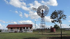
- The 'Wandoan Windmill' stands at the town entrance on the highway. It is across from a colorful mural painted on the town's main water tank.
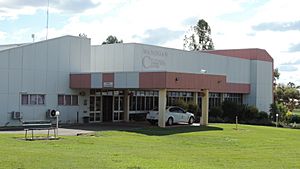
- A large mural inside the Community Cultural Centre shows local history. It is painted on a huge piece of local sandstone.
- The Wandoan Races are horse racing events held once or twice a year.
- Wandoan Unlicensed Airport is just 1.2 kilometers (0.75 miles) away.
The Wandoan Information Centre on Royd Street helps visitors. It is in an old railway station building and is easy to spot because of the big windmill next to it.
Education in Wandoan
Wandoan State School P-10 is a government school for students from Prep (the first year of school) to Year 10. It is located at 49 North Street. In 2018, the school had 70 students and 13 teachers.
There are no schools in Wandoan that offer schooling up to Year 12. Students who want to continue their education past Year 10 can choose distance education (learning from home) or attend a boarding school.
Community Places in Wandoan
The Western Downs Regional Council runs the Wandoan Community Cultural Centre. It is at 6 Henderson Road. This center has a public hall for meetings and entertainment, and it also houses the public library.
St Joseph's Catholic Church is on the corner of East and Hamlyn Streets. The Wandoan Presbyterian Church is located in Moore Street.
Services in Wandoan
Wandoan offers many services to its residents:
- Ambulance service, a doctor, and an out-patients clinic.
- A fire brigade and a police station.
- Town water, TV reception (through satellite), and normal electricity.
- A coach bus service (three times a week) and vehicle service. The railway station is no longer used.
- A chemist, a hotel/motel, and an official post office where mail is collected daily.
Climate in Wandoan
The average temperature in Wandoan ranges from about 21°C (70°F) to 34°C (93°F) in summer. In winter, temperatures usually range between 5°C (41°F) and 22°C (72°F).
Famous People from Wandoan
- Darren Lockyer is a famous Australian rugby league captain. He grew up in Wandoan.
- Wild Toby was an Aboriginal bushranger from the area.
 | Selma Burke |
 | Pauline Powell Burns |
 | Frederick J. Brown |
 | Robert Blackburn |


