Halaib Triangle facts for kids
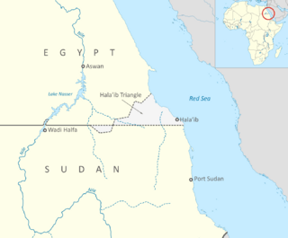
The Halaib Triangle is a piece of land on the Northeast African coast of the Red Sea. It measures about 20,580 square kilometers (7,950 sq mi). The area is named after the town of Halaib.
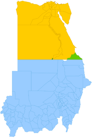
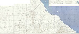
This area is special because two different borders were drawn a long time ago. One was a "political boundary" in 1899, which followed the 22nd parallel north (a line of latitude). The other was an "administrative boundary" in 1902, which gave Sudan control over this land, even though it was north of the 22nd parallel.
When Sudan became independent in 1956, both Egypt and the Sudan claimed this land as their own. This is called a territorial dispute. For a while, the Halaib Triangle was considered part of Sudan. However, in 1994, the Egyptian military took control of the area. Since then, Egypt has been managing it and investing in its development. Egypt has clearly stated that it will not agree to international arbitration (where an outside group helps settle the dispute) or even political talks about the area.
The shape of the area is called a "triangle," but it's not a perfect one. Its southern edge follows the 22nd parallel. The northeastern edge is the Red Sea coast, and the northwestern edge is uneven. There's also a smaller area south of the 22nd parallel called Bir Tawil. Interestingly, neither Sudan nor Egypt claims Bir Tawil.
People in the Halaib Triangle speak Beja, Arabic, and English.
Quick facts for kids
Halaib Triangle
مُثَلَّث حَلَايِب
|
|
|---|---|
|
Disputed territory
|
|

Location of the Halaib Triangle
|
|
| Country | De jure Disputed area between: De facto Administered by: |
| Governorate | Red Sea Governorate (Egypt) |
| State | Red Sea State (Sudan) |
| Area | |
| • Total | 20,580 km2 (7,950 sq mi) |
| • Disputed area | 20,580 km2 (7,950 sq mi) |
| Lowest elevation | 0 m (0 ft) |
Contents
What's in a Name?
The name "Halaib Triangle" comes from the town of Halaib. In Arabic, it's called Arabic: مُثَلَّث حَلَايِب (Muthallath Ḥalāyib), which means "Halaib Triangle."
A Look at History
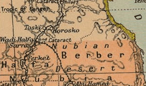
The story of the Halaib Triangle began in 1899. At that time, the UK and Egypt were working together to govern Sudan. They agreed that Sudan's border would be south of the 22nd parallel. However, in 1902, the UK drew another "administrative boundary." This new line was meant to match where different tribes lived and used the land.
- The 1902 border gave Egypt control over the land of the Ababda tribe, even though it was south of the 22nd parallel.
- It gave Sudan control over the grazing land of the Beja tribe, even though it was north of the 22nd parallel. This area included the towns of Halaib and Abu Ramad.
When Sudan became independent in 1956, Egypt said the 1899 border (the 22nd parallel) was the real one. Sudan, however, said the 1902 administrative border was the correct one. This is why both countries claim the Halaib Triangle.
On the other hand, the area south of the 22nd parallel that Egypt used to manage, called Bir Tawil, is not claimed by either country. It's like a "no man's land."
Early Disputes
In 1958, after Sudan became independent, Egypt sent troops into the Halaib Triangle. This happened when Sudan was planning elections there. Egypt's president, Gamal Abdel Nasser, wanted to hold a vote for Egypt and Syria to unite. But the troops left later that month. For many years, Halaib was considered part of Sudan and took part in Sudanese elections.
Even though both countries claimed the land, they shared control until 1992. That year, Sudan allowed a Canadian oil company to look for oil in the waters off the Triangle. Egypt disagreed strongly. The oil company decided to wait until the ownership issue was solved.
In 1994, Sudan complained to the United Nations Security Council and other groups, saying Egypt had sent its military and officials into Sudanese territory many times. In 1995, Egypt refused Sudan's request to discuss the dispute. After an attempt to harm Egyptian President Hosni Mubarak, Egypt accused Sudan of being involved. As a result, Egypt took stronger control of the Halaib Triangle, removing Sudanese police and officials.
Recent Times
Relations between Egypt and Sudan got a bit better in 1998. They said they would work together to solve the Halaib dispute. But later that year, Sudan accused Egypt of bothering Sudanese citizens in the area, which Egypt denied. By 1999, they were talking to improve their relationship. In 2000, Sudan pulled its forces out of the area, and Egypt has been in control ever since.
In 2004, Sudanese president Omar Al-Bashir said that even though Sudan had left in 2000, the area still belonged to Sudan. He said Sudan had "never given it up." He repeated this claim in 2010, saying "Halayeb is Sudanese and will always be Sudanese."
Some groups in Sudan, like the Eastern Front, also believe Halaib is part of Sudan. They say the people there are connected to Sudan by their ethnicity, language, and tribes. They think the issue should be decided by international arbitration, like another dispute between Northern and Southern Sudan.
In 2009, Sudan's election commission said Halaib was an election district for Sudan's 2010 elections. But Egyptian authorities did not allow Sudanese election officials to enter the area. In December 2009, a Sudanese official was also stopped from entering. He wanted to "assert [Sudanese] sovereignty" and support Sudanese army members who were still in the area.
Egypt has been developing the area. The Egyptian electricity company built a power line to supply electricity to the town of Alshalateen, and it will extend to Abu Ramad and Halaib. A new paved road now connects the triangle to Port Sudan.
In 2010, an Egyptian newspaper reported that leaders of three tribes in the Halaib Triangle – Ababda, el-Basharya, and Beja – supported Egypt's claim. They said they were Egyptian citizens and had all the rights of Egyptians.
In November 2010, a letter was sent to the President of Sudan from Halaib. It complained that 20 villages were forced into Egyptian election districts. It also said that the area was like a "siege," with barbed wire, and that goods from Sudan were not allowed in. The letter also mentioned that the tribes' camels could not travel to their traditional grazing lands in Sudan.
The Egyptian government has turned the village of Halaib into a city and is building many projects there. In 2015, a representative for the Halaib area was elected in the Egyptian parliamentary election.
In 2016, an Egyptian official said that these are Egyptian territories and Egypt has no more comments. International arbitration needs both sides to agree, and Egypt has refused it so far.
A new paved road has been built that goes through the western part of the triangle to a border pass called Suhin. This road will eventually connect to the city of Abu Hamad in Sudan.
Towns and Villages
The main town in the Halaib Triangle is Abu Ramad. It's about 30 kilometers (19 mi) northwest of Halaib, right on the Red Sea coast. Abu Ramad is the last stop for buses coming from Cairo and other Egyptian cities. Another small village is Hadarba, southeast of Halaib town. Alshalateen is an Egyptian town just north of the disputed area. The closest Sudanese town south of the disputed area is Osief (Marsa Osief), which is about 26 kilometers (16 mi) south of the 22nd parallel.
Nature and Landscape
The Halaib region is special for its nature. It's where some Afrotropical plants and animals reach their northernmost point, especially around Mount Elba. This makes it unique compared to Egypt's usual Mediterranean and North African environments. You can find many acacia trees, mangroves, and other shrubs here. There are also plants found nowhere else, like Biscutella elbensis.
The highest mountains in the area are Mount Elba (1,435 meters or 4,708 ft), Mount Shellal (1,409 meters or 4,623 ft), Mount Shendib (1,911 meters or 6,270 ft), and Mount Shendodai (1,526 meters or 5,007 ft). The mountainous area of Gebel Elba is a nature reserve protected by Egypt.
Map
See also
 In Spanish: Triángulo de Hala'ib para niños
- Annexation
- Bir Tawil, an adjoining terra nullius, claimed by neither Egypt nor the Sudan
- Egypt–Sudan border
- Egypt–Sudan relations
- Foreign relations of Egypt
- Foreign relations of Sudan
- Territorial dispute
- Wadi Halfa Salient
 | Toni Morrison |
 | Barack Obama |
 | Martin Luther King Jr. |
 | Ralph Bunche |


