
Happy Camp, California facts for kids
Quick facts for kids
Happy Camp, California
athithúf-vuunupma
|
|
|---|---|

Location of Happy Camp in Siskiyou County, California
|
|

Happy Camp, California
Location in California
|
|
| Country | |
| State | |
| County | |
| Area | |
| • Total | 12.346 sq mi (31.976 km2) |
| • Land | 12.107 sq mi (31.357 km2) |
| • Water | 0.239 sq mi (0.619 km2) 1.94% |
| Elevation | 1,660 ft (505 m) |
| Population
(2020)
|
|
| • Total | 905 |
| • Density | 73.30/sq mi (28.302/km2) |
| Time zone | UTC-8 (PST) |
| • Summer (DST) | UTC-7 (PDT) |
| ZIP Code |
96039
|
| Area code(s) | 530 |
| FIPS code | 06-32030 |
Happy Camp is a small community in Siskiyou County, California, United States. It's known as a census-designated place (CDP), which means it's a special area counted by the census but isn't officially a city. In the Karuk language, its name is athithúf-vuunupma.
As of 2020, about 905 people live in Happy Camp. This is a bit less than the 1,190 people who lived there in 2010. The town is often called "The Heart of the Klamath" because of its location.
Happy Camp is found on California State Route 96. It's about 70 miles (113 km) west of Interstate 5. It's also about 100 miles (161 km) northeast of Willow Creek. You can reach Takilma, Oregon from Happy Camp, but the shortest road over Grey Back Pass is only open in summer. It's not cleared when it snows. The Forest Service office in Happy Camp can tell you about road conditions.
Contents
Why is it Called Happy Camp?
Happy Camp got its name from early miners. They found a lot of gold and platinum there, which made them very happy! Because of its unique name, Happy Camp often appears on lists of unusual place names.
One story says that a miner named Jack Titus named the camp. His partner, James Camp, was so excited when they arrived that he said, "This is the happiest day in my life!" Another early mention of the camp in 1851 called it "Mr Roache's Happy Camp."
Exploring Happy Camp's Geography
Happy Camp is located right on the Klamath River. Many smaller creeks also flow into the river here. These include Elk Creek, Indian Creek, and Doolittle Creek.
The area of Happy Camp covers about 12.3 square miles (31.97 square kilometers). Most of this area is land, with a small part being water.
Gateway to the Marble Mountains
Happy Camp is known as the "Gateway to the Marbles." This is a huge wilderness area with many trails. You can find these trails within 10 miles (16 km) of town. The U.S. Forest Service provides maps and information about the trails.
The Marble Mountains are vast and have nearly a hundred lakes. Some interesting lakes include:
- Spirit Lake: This lake is said to "glow" in the dark because of a special chemical.
- Ukonom Lake: It's a very large and beautiful lake, even though the area is recovering from past fires.
- Green and Blue Granite Lakes: These lakes have cold, clear water where trout swim.
You can also spot many animals in the Marble Mountains. Deer, bears, elk, and mountain lions are common here.
People of Happy Camp
In 2010, Happy Camp had a population of 1,190 people. Most of the people living there were White (68.4%) or Native American (23.3%). A small number of people were from other racial backgrounds. About 8% of the population was Hispanic or Latino.
The average age of people in Happy Camp in 2010 was about 47 years old. About 20% of the population was under 18 years old.
Happy Camp hosts an annual event called the Bigfoot Jamboree. This festival is organized by the Happy Camp Community Council. The town is also part of the "Bigfoot Scenic Byway," which is an 89-mile (143 km) stretch of California State Route 96. You can even see an 18-foot-tall Bigfoot statue made from recycled metal in town!
Happy Camp's Climate
Happy Camp has a mediterranean climate. This means it has very hot and dry summers. The mountains around the town block the cool air from the Pacific Ocean. This makes summer days much hotter than in coastal areas nearby.
Winters are cooler and get more snow than places further south in California. However, they are still mild compared to areas in the eastern United States. The dry summers can cause wildfires, like the 2014 Happy Camp Complex Fire. This fire took months to put out. Even with dry summers, the area stays green because of a lot of rain in winter.
The average temperature in July is around 73°F (23°C). But the average high temperature can reach about 95°F (35°C).
| Climate data for Happy Camp | |||||||||||||
|---|---|---|---|---|---|---|---|---|---|---|---|---|---|
| Month | Jan | Feb | Mar | Apr | May | Jun | Jul | Aug | Sep | Oct | Nov | Dec | Year |
| Record high °F (°C) | 64.9 (18.3) |
80.1 (26.7) |
91.9 (33.3) |
95 (35) |
108.0 (42.2) |
111.9 (44.4) |
115.0 (46.1) |
115.0 (46.1) |
109.9 (43.3) |
100.0 (37.8) |
82.0 (27.8) |
69.1 (20.6) |
115.0 (46.1) |
| Mean maximum °F (°C) | 56.6 (13.7) |
65.4 (18.6) |
76.4 (24.7) |
86.0 (30.0) |
95.0 (35.0) |
102.0 (38.9) |
106.0 (41.1) |
104.9 (40.5) |
100.1 (37.8) |
87.6 (30.9) |
68.3 (20.2) |
57.5 (14.2) |
105.5 (40.8) |
| Mean daily maximum °F (°C) | 48.2 (9.0) |
55.0 (12.8) |
61.0 (16.1) |
70.0 (21.1) |
77.7 (25.4) |
85.6 (29.8) |
95 (35) |
94.1 (34.5) |
86.9 (30.5) |
72.1 (22.3) |
56.1 (13.4) |
48.0 (8.9) |
70.8 (21.6) |
| Daily mean °F (°C) | 40.5 (4.7) |
43.9 (6.6) |
47.7 (8.7) |
53.8 (12.1) |
59.7 (15.4) |
66.4 (19.1) |
73.0 (22.8) |
72.0 (22.2) |
66.0 (18.9) |
56.1 (13.4) |
45.7 (7.6) |
40.5 (4.7) |
55.4 (13.0) |
| Mean daily minimum °F (°C) | 30.7 (−0.7) |
33.1 (0.6) |
34.3 (1.3) |
37.6 (3.1) |
42.1 (5.6) |
46.9 (8.3) |
51.3 (10.7) |
49.8 (9.9) |
45.1 (7.3) |
39.9 (4.4) |
35.8 (2.1) |
33.1 (0.6) |
40.0 (4.4) |
| Mean minimum °F (°C) | 19.1 (−7.2) |
23.9 (−4.5) |
26.3 (−3.2) |
29.2 (−1.6) |
32.9 (0.5) |
37.3 (2.9) |
42.0 (5.6) |
42.0 (5.6) |
35.9 (2.2) |
29.8 (−1.2) |
25.7 (−3.5) |
22.1 (−5.5) |
16.0 (−8.9) |
| Record low °F (°C) | 6.1 (−14.4) |
6.1 (−14.4) |
19.0 (−7.2) |
21.9 (−5.6) |
21.9 (−5.6) |
27.0 (−2.8) |
28.0 (−2.2) |
30.0 (−1.1) |
24.1 (−4.4) |
18.0 (−7.8) |
10.0 (−12.2) |
−2.0 (−18.9) |
−2.0 (−18.9) |
| Average precipitation inches (mm) | 9.1 (230) |
7.1 (181) |
6.1 (155) |
2.8 (72) |
1.7 (43) |
0.8 (21) |
0.35 (9.0) |
0.35 (9.0) |
0.9 (23) |
3.3 (85) |
5.7 (146) |
8.5 (215) |
46.7 (1,189) |
| Average snowfall inches (cm) | 5.2 (13) |
3.0 (7.6) |
1.5 (3.8) |
0.1 (0.25) |
0 (0) |
0 (0) |
0 (0) |
0 (0) |
0 (0) |
0 (0) |
0.7 (1.8) |
3.4 (8.6) |
13.9 (35.05) |
| Average precipitation days | 14 | 12 | 12 | 9 | 7 | 4 | 1 | 2 | 3 | 7 | 11 | 13 | 95 |
Local Economy and Education
The main local tribe, the Karuk Tribe, has its headquarters in Happy Camp. The U.S. Forest Service also has an office here. This office helps manage the Happy Camp/Oak Knoll Ranger Districts of the Klamath National Forest.
Happy Camp has several schools for students of all ages:
- Happy Camp Elementary School
- Happy Camp High School
- Jefferson High Continuation School
- College of the Siskiyous - Happy Camp (for older students)
Famous People from Happy Camp
Some notable people have connections to Happy Camp:
- Daniel R. Hokanson: A high-ranking officer, a lieutenant general, in the United States Army.
- Jetty Rae: A musician and independent artist who lived in Happy Camp when she was a child.
- Ricky Ray: A professional football quarterback who was born in Happy Camp.
Images for kids
-
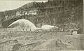
Miners looking for platinum using hydraulic mining in early Happy Camp.
_(14597622239).jpg)
See also
 In Spanish: Happy Camp para niños
