Hatfield (CDP), Massachusetts facts for kids
Quick facts for kids
Hatfield, Massachusetts
|
|
|---|---|

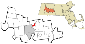
Location in Hampshire County in Massachusetts
|
|
| Country | United States |
| State | Massachusetts |
| County | Hampshire |
| Town | Hatfield |
| Area | |
| • Total | 2.54 sq mi (6.57 km2) |
| • Land | 2.45 sq mi (6.34 km2) |
| • Water | 0.09 sq mi (0.22 km2) |
| Elevation | 121 ft (37 m) |
| Population
(2020)
|
|
| • Total | 1,453 |
| • Density | 593.06/sq mi (229.02/km2) |
| Time zone | UTC-5 (Eastern (EST)) |
| • Summer (DST) | UTC-4 (EDT) |
| ZIP code |
01038
|
| Area code(s) | 413 |
| FIPS code | 25-29230 |
| GNIS feature ID | 0609017 |
Hatfield is a small community, or 'CDP' (which stands for census-designated place), located in the town of Hatfield in Massachusetts, USA. It is part of Hampshire County.
In 2020, about 1,453 people lived in the Hatfield CDP. This community is also part of the larger Springfield Metropolitan Area.
Contents
Exploring Hatfield's Location
The Hatfield CDP is found in the southern part of the town of Hatfield. It is located near the Connecticut River. The CDP includes the main village of Hatfield. It also has residential areas stretching west along Elm Street and north towards Cow Bridge Brook.
How to Get Around
Interstate 91 is a major highway. It passes about 2 miles (3.2 km) west of the center of Hatfield. You can get to Hatfield from Exit 21 on Elm Street.
Hatfield is about 6 miles (9.7 km) northeast of Northampton. It is also about 24 miles (39 km) north of Springfield.
Land and Water Area
The United States Census Bureau reports that the Hatfield CDP covers a total area of about 2.4 square miles (6.2 square kilometers). Most of this area, about 2.4 square miles (6.2 square kilometers), is land. A small part, about 0.09 square miles (0.2 square kilometers), is water. This means about 3.53% of the CDP's area is water.
Who Lives in Hatfield?
| Historical population | |||
|---|---|---|---|
| Census | Pop. | %± | |
| 2020 | 1,453 | — | |
| U.S. Decennial Census | |||
Let's look at the people who live in Hatfield. In 2000, there were 1,298 people living in the CDP. These people lived in 566 households. About 336 of these were families.
Population Details
The population density was about 555 people per square mile (214.2 people per square kilometer). There were 585 homes, with an average of 250 homes per square mile (96.5 homes per square kilometer).
Most people in Hatfield are White, making up about 98.07% of the population. Other groups include Asian (0.77%), and people from two or more races (0.15%). About 1.23% of the population identified as Hispanic or Latino.
Households and Families
Out of the 566 households:
- About 27.4% had children under 18 living with them.
- Half of the households (50.0%) were married couples living together.
- About 7.1% had a female head of household with no husband present.
- About 40.5% were not families.
Many households (32.3%) had only one person living there. About 17.7% had someone living alone who was 65 years old or older. The average household had 2.29 people, and the average family had 2.96 people.
Age Groups
The population in Hatfield is spread across different age groups:
- 21.6% were under 18 years old.
- 4.2% were between 18 and 24 years old.
- 28.0% were between 25 and 44 years old.
- 25.8% were between 45 and 64 years old.
- 20.4% were 65 years old or older.
The average age of people in Hatfield was 43 years. For every 100 females, there were about 86 males. For every 100 females aged 18 and over, there were about 83.6 males.
Income Information
The average income for a household in Hatfield was $48,281. For families, the average income was $63,833. Males earned about $39,167 on average, while females earned about $31,477. The average income per person in the CDP was $23,145.
Very few families (none) and only 2.4% of the total population lived below the poverty line. This included no one under 18 and 4.5% of those over 64.
See also
 In Spanish: Hatfield (condado de Hampshire) para niños
 | Aurelia Browder |
 | Nannie Helen Burroughs |
 | Michelle Alexander |

