
Haute-Sorne facts for kids
Quick facts for kids
Haute-Sorne
|
||
|---|---|---|

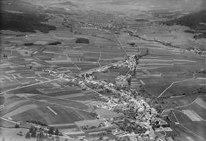
Sorne river at Bassecourt
|
||
|
||

Haute-Sorne
Location in Switzerland

Haute-Sorne
Location in Canton of Jura
|
||
| Country | Switzerland | |
| Canton | Jura | |
| District | Delémont | |
| Area | ||
| • Total | 71.04 km2 (27.43 sq mi) | |
| Population
(Dec 2020 )
|
||
| • Total | 7,167 | |
| • Density | 100.887/km2 (261.30/sq mi) | |
| Postal code |
2854
|
|
| Surrounded by | Boécourt, Develier | |

Haute-Sorne is a town located in the Jura canton of Switzerland. It is part of the Delémont district. This town was formed on January 1, 2013. It was created by combining five smaller towns: Bassecourt, Courfaivre, Glovelier, Soulce, and Undervelier.
Contents
A Look at History
Each part of Haute-Sorne has its own long history. Bassecourt was first mentioned in old writings in 1160. It was called Baressicort back then. The small village of Berlincourt, which is part of Bassecourt, was first noted in 1303.
Courfaivre's name appeared in records in 1147 as Curfavro. Glovelier was first known as Lolenviler in 1139. Soulce was mentioned in 1148 as Sulza. Undervelier was first written about in 1179 as Undreviller.
Exploring the Geography


The towns that now make up Haute-Sorne cover a total area of about 71.06 square kilometers (27.44 sq mi). This land is used for different purposes. A large part is for farming, and another big part is covered by forests. There are also areas with buildings and roads.
Bassecourt's Landscape
Bassecourt itself covers about 16.4 square kilometers (6.3 sq mi). About 37.5% of this land is used for farming. Forests cover almost half of the area, at 49.9%. Buildings and roads take up about 12.2%. A small part is rivers or lakes, and a tiny bit is unproductive land. Bassecourt is located along the Sorne river in the Delemont valley. It sits where two important roads meet. These roads connect Delémont to La Chaux-de-Fonds and Porrentruy to Biel/Bienne. The area includes the main village of Bassecourt and the small village of Berlincourt.
Courfaivre's Surroundings
Courfaivre has an area of about 12.4 square kilometers (4.8 sq mi). More than half of its land, 51.0%, is used for agriculture. Forests make up 39.6% of the area. About 8.4% of the land has buildings and roads. A very small part is rivers or lakes, and unproductive land. Courfaivre is found on the right bank of the Sorne river. It is along the road that goes from Delémont to Glovelier.
Glovelier's Features
Glovelier covers about 14.3 square kilometers (5.5 sq mi). Farming uses 41.8% of its land. Forests are even more common, covering 46.8%. Buildings and roads take up 10.9% of the area. Rivers, lakes, and unproductive land make up very small portions. Glovelier is at the western end of the Delemont valley. It is where old roads from Porrentruy to Biel and from Delemont to La Chaux-de-Fonds cross. The area includes the village of Glovelier and the small village of Sceut.
Soulce's Valley
Soulce has an area of about 14.8 square kilometers (5.7 sq mi). Only 26.9% of its land is used for farming. A large part, 70.7%, is covered by forests. Buildings and roads make up 1.9% of the area. Rivers, lakes, and unproductive land are very small parts. Soulce is located in a small valley. This valley is east of Undervelier. The village grew up along a small stream in this valley.
Undervelier's Mountains and Rivers
Undervelier covers about 14.0 square kilometers (5.4 sq mi). About 24.2% of its land is for farming. Forests cover a large 73.3% of the area. Buildings and roads take up 2.1%. Rivers, lakes, and unproductive land are very small parts. Undervelier is located between two canyons of the Sorne river. It is also at the base of the Pichoux mountain.
Population Information
The total population of Haute-Sorne is 6,786 people (as of 2011).
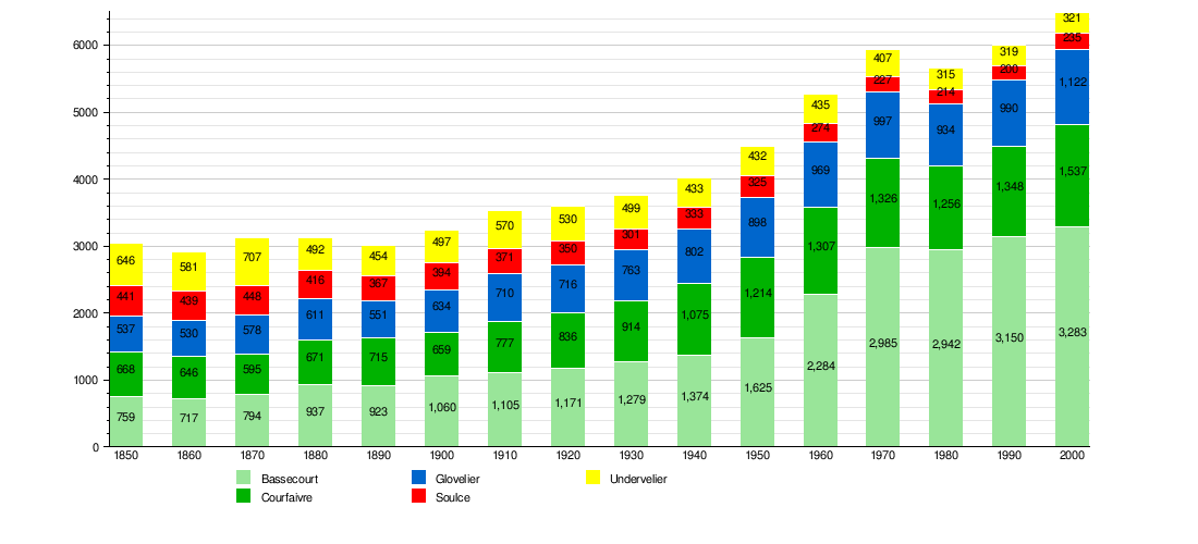
Historic Population Trends
This chart shows how the population of the different parts of Haute-Sorne has changed over many years:
Important Heritage Sites
Some places in Haute-Sorne are very important for their history and culture. These are called Swiss heritage sites of national significance.
The Saint-Germain-d'Auxerre Church in Courfaivre is one such site. The Farm House at Au Village 17 and the prehistoric shelter at Le Mont in Glovelier are also listed. The entire village of Soulce and the Les Forges area are recognized as part of the Inventory of Swiss Heritage Sites. This means they are special places that need to be protected.
-
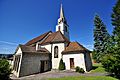
Saint-Germain-d'Auxerre Church
-
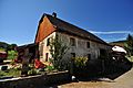
Glovelier farm house
-
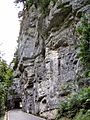
Road through one of the Gorges of Pichoux


Places to See
If you visit Haute-Sorne, there are several interesting sights. In the Undervelier area, you can explore the cave of Sainte-Colombe. You can also see the beautiful Gorges of Pichoux, which are like narrow river canyons.
Other places to visit include the Vellerat Posé, known for its green scenery. There is also the chapel Place Roland Béguelin. This chapel was designed by Jeanne Bueche and features amazing stained glass windows by André Bréchet.
Getting Around: Transportation
Haute-Sorne has good train connections. There are four railway stations in the municipality. These are Glovelier, Bassecourt, Courfaivre, and Combe-Tabeillon.
The first three stations (Glovelier, Bassecourt, Courfaivre) are on the Delémont–Delle line. From here, you can take regular trains to Biel/Bienne, Olten, and even Meroux in France. Glovelier and Combe-Tabeillon stations are also on a narrow-gauge line. This line connects Glovelier with La Chaux-de-Fonds.
See also
 In Spanish: Haute-Sorne para niños
