Havelock North facts for kids
Quick facts for kids
Havelock North
Karanema
|
|
|---|---|
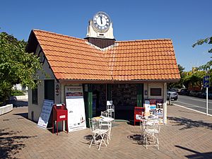
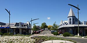
Clock Tower Building (1914)
|
|
| Country | New Zealand |
| Region | Hawke's Bay |
| Territorial authority | Hastings District |
| Ward |
|
| Electorates |
|
| Area | |
| • Total | 23.12 km2 (8.93 sq mi) |
| Population
(June 2023)
|
|
| • Total | 15,200 |
| • Density | 657.4/km2 (1,703/sq mi) |
| Postcode |
4130
|
| Area code(s) | 06 |
Havelock North, also known by its Māori name Karanema, is a lovely town in the Hawke's Bay region of New Zealand's North Island. It's located just under 2 kilometers southeast of the city of Hastings. For many years, Havelock North was its own local area. However, in 1989, it became part of the larger Hastings District. Today, the Hastings District Council looks after the town.
Contents
Discovering Havelock North
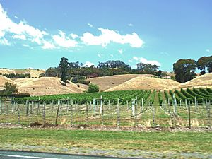
Locals often call Havelock North "the village." It sits on the Heretaunga Plains, a flat area of land. The town is surrounded by many fruit orchards and vineyards. Because of this, a lot of its work involves fruit and wine production. There's also a special research center for growing plants.
The soil between Havelock North and Hastings is very rich and fertile. This has stopped the two towns from growing into one big city. Havelock North itself is mostly homes and rural areas. It has a smaller, central area for shops and businesses. Many of its 15,000 residents travel to nearby Hastings or Napier for work each day.
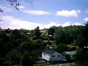
Havelock North is quite hilly. Small valleys have formed where creeks and streams flow down from higher ground. Some of this land is too steep for building, so it's used for forests, parks, or nature reserves. This makes the town look like it naturally has many trees and bushes.
Te Mata Peak: A Local Landmark
The town is at the base of a famous landmark called Te Mata Peak. This is a 399-meter tall rock outcrop. According to local Māori legends, Te Mata Peak is the body of a giant named Te Mata o Rongokako. The dip in the land behind his head is where he supposedly tried to bite through a mountain range. This legend says he turned to stone because his stomach was full.
Water Supply
Both Hastings and Havelock North get their water from underground water systems called aquifers. The Te Mata aquifer, which supplies Havelock North, has good quality water. It is very similar to Hastings' water, but with slightly more calcium. Hastings sits right over the Heretaunga Plains aquifer system.
Havelock North's Past
Havelock North was planned and set up by the government. This happened after land known as 'Karanema's Reserve' was bought from Māori owners in 1858. The first layout of the village was made in 1860. It was named after Sir Henry Havelock, a person involved in the Indian Uprising. This followed a local tradition of naming towns after important men from Imperial India.
The people who founded Havelock North hoped it would become a much bigger town. However, in 1874, the Wellington–Napier railway line was built. It went a bit far from Havelock North, making Hastings a more convenient place for people to live.
Rivers and Floods
In the early 1800s, the local Karamu Stream was part of the much larger Ngaruroro River system. It was even called the "River Plassey," a name also given to a street in the village. This was after the battle of Plassey in 1757 near Calcutta. Old maps of Havelock North show places where ferries would dock. Boats would travel up and down the river to pick up and deliver supplies. This practice stopped in the 1880s. Several large floods changed the Ngaruroro River's path, moving it further north, away from Havelock North. Later, during the 1931 earthquake, a bridge over the Karamu was completely destroyed.
Havelock North in the North Island has grown larger than its namesake, Havelock, in the Marlborough Sounds of the South Island.
Water Safety Event
From August 12 to 29, 2016, the town experienced a significant event related to its water supply. A type of bacteria called Campylobacter entered the town's water after heavy rain caused runoff from a sheep farm to enter the Brookvale boreholes. This led to many people becoming unwell.
Population Facts
Havelock North covers an area of about 23.12 square kilometers. As of 2018, it had an estimated population of about 14,331 people. This means there were about 620 people per square kilometer.
The town's population has grown over the years:
- In 2001, there were 10,392 people.
- In 2006, there were 12,222 people.
- In 2013, there were 13,167 people.
- In 2018, there were 14,331 people.
At the 2018 New Zealand census, there were 5,505 households. There were 6,564 males and 7,770 females. About 19.3% of the people were under 15 years old.
Most people in Havelock North are of European descent (91.0%). About 10.0% are Māori, 1.3% are Pacific peoples, and 3.5% are Asian. About 20.8% of the people were born outside New Zealand.
When asked about their religious beliefs, 46.5% said they had no religion. About 43.5% were Christian. Smaller numbers followed Māori religious beliefs, Hinduism, Islam, or Buddhism.
Many adults in Havelock North have higher education. About 27.9% of people aged 15 or older had a bachelor's degree or higher. About 44.1% of people aged 15 or older worked full-time.
Schools in Havelock North
Havelock North has eight schools for students of different ages:
- Havelock North Primary School is a state primary school for Year 1–6 students.
- Lucknow School is also a state primary school for Year 1–6 students.
- Te Mata School is another state primary school for Year 1–6 students.
- Hereworth School is a private school for Year 1–8 students.
- Havelock North Intermediate is a state intermediate school for Year 7–8 students.
- Havelock North High School is a state secondary school for Year 9–13 students. It opened in 1975.
- Iona College is a state-integrated Presbyterian girls' secondary school for Year 7–13 students. It opened in 1914.
- Woodford House is a state-integrated Anglican girls' secondary school for Year 7–13 students. It was started in 1894.
Hereworth, Iona College, and Woodford House are boarding schools. This means some students live at the school. They also accept a small number of local students who attend during the day.
Famous People from Havelock North
Many interesting people have lived in Havelock North, including:
- Mac Cooper (1910–1989), who was an expert in farming and an author.
- Alan Duff (born 1950), a well-known novelist.
- Dr Robert William Felkin (1853–1926), a medical missionary and explorer.
- Virginia Heath (born 1959), a film director and academic.
- Amy Hodgson (1888–1983), a botanist who studied plants.
- Alfred Meebold (1863–1952), a botanist and writer who passed away in Havelock North.
- Amanda Palmer (born 1976), a talented musician.
- Jarrod Smith (born 1984), a professional footballer.
- Ashley Stichbury (1971–2002), a racing driver.
- Herbert Sutcliffe (1878–1971), who promoted good health.
- Ihaia West (born 1992), a rugby union player.
Climate in Havelock North
Havelock North has a mild climate. Here's a look at the average temperatures and rainfall:
| Climate data for Havelock (1981–2010) | |||||||||||||
|---|---|---|---|---|---|---|---|---|---|---|---|---|---|
| Month | Jan | Feb | Mar | Apr | May | Jun | Jul | Aug | Sep | Oct | Nov | Dec | Year |
| Mean daily maximum °C (°F) | 24.4 (75.9) |
24.1 (75.4) |
22.5 (72.5) |
19.8 (67.6) |
17.4 (63.3) |
14.9 (58.8) |
13.9 (57.0) |
14.8 (58.6) |
16.9 (62.4) |
19.2 (66.6) |
20.8 (69.4) |
23.1 (73.6) |
19.3 (66.8) |
| Daily mean °C (°F) | 18.2 (64.8) |
18.2 (64.8) |
16.5 (61.7) |
13.5 (56.3) |
11.1 (52.0) |
8.7 (47.7) |
8.2 (46.8) |
9.1 (48.4) |
11.1 (52.0) |
13.0 (55.4) |
14.8 (58.6) |
17.3 (63.1) |
13.3 (56.0) |
| Mean daily minimum °C (°F) | 12.1 (53.8) |
12.3 (54.1) |
10.4 (50.7) |
7.3 (45.1) |
4.8 (40.6) |
2.6 (36.7) |
2.5 (36.5) |
3.3 (37.9) |
5.3 (41.5) |
6.8 (44.2) |
8.8 (47.8) |
11.4 (52.5) |
7.3 (45.1) |
| Average rainfall mm (inches) | 49 (1.9) |
54 (2.1) |
71 (2.8) |
69 (2.7) |
64 (2.5) |
84 (3.3) |
89 (3.5) |
88 (3.5) |
59 (2.3) |
55 (2.2) |
43 (1.7) |
70 (2.8) |
795 (31.3) |
| Mean monthly sunshine hours | 227.2 | 197.3 | 173.3 | 179.9 | 120.9 | 124.3 | 127.5 | 138.0 | 164.4 | 189.4 | 184.0 | 215.8 | 2,042 |
| Source: NIWA (rainfall 1951–1980) | |||||||||||||


