
Hawaiian–Emperor seamount chain facts for kids
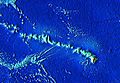
The Hawaiian–Emperor seamount chain is a super long line of underwater mountains, islands, and reefs in the Pacific Ocean. It stretches for over 5,800 kilometers (about 3,600 miles)! This amazing chain includes the famous Hawaiian Islands and many other underwater mountains called seamounts. Many of these seamounts are flat-topped, and we call them guyots.
The chain starts near the Aleutian Trench in the far northwest Pacific. It goes all the way to the Loʻihi seamount, which is the youngest volcano in the chain. Loʻihi is about 35 kilometers (22 miles) southeast of the Island of Hawaiʻi. The oldest part of this chain is the Detroit Seamount, which is about 81 million years old. The Meiji Guyot, even further north, might be even older!
Contents
How the Chain Was Made: The Hotspot Story

In 1963, a smart geologist named John Tuzo Wilson figured out how this huge chain was formed. He explained that it was created by a special place called a hotspot. Imagine a giant blowtorch under the Earth's surface! This hotspot stays in one place, but the huge tectonic plate (a giant piece of the Earth's crust) above it slowly moves.
As the Pacific tectonic plate moves over the hotspot, the hotspot punches through, creating new volcanoes. Over millions of years, as the plate keeps moving, it leaves a trail of volcanoes behind it. The volcanoes that move away from the hotspot become inactive and slowly sink under the ocean, forming seamounts.
The Big Bend in the Chain
If you look at a map of the Hawaiian–Emperor seamount chain, you'll see a clear "bend" or "V" shape in it. This bend is very important! It shows that the Pacific plate suddenly changed direction about 47 million years ago. Before that, it was moving mostly north. After the bend, it started moving more to the northwest. This bend is a cool example of how Earth's giant plates can shift their path quite suddenly.
Did the Hotspot Move Too?
For a long time, scientists thought the hotspot stayed perfectly still. But recent research suggests that the hotspot itself might have moved a little bit over time. Scientists found clues by studying tiny magnetic minerals in old lava flows from some of the seamounts. These minerals act like tiny compasses, showing the direction of Earth's magnetic field when the lava cooled. This helps them figure out how the hotspot might have shifted.
More to Explore
Images for kids
-
The Hawaiian-Emperor seamount chain, zoomed in on the modern-day islands

See also
 In Spanish: Cadena de montes submarinos Hawái-Emperador para niños
