Heart River (North Dakota) facts for kids
Quick facts for kids Heart River |
|
|---|---|

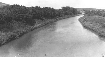
The Heart River, near Mandan, North Dakota, 1949.
|
|

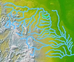
A map of the Missouri River watershed, highlighting the Heart River.
|
|
| Country | United States |
| State | North Dakota |
| Physical characteristics | |
| Main source | Near Saddle Butte Belfield, Billings County 2,740 ft (840 m) 46°56′13″N 103°13′49″W / 46.93694°N 103.23028°W |
| River mouth | Missouri River Bismarck, Morton County 1,624 ft (495 m) 46°46′03″N 100°50′31″W / 46.76750°N 100.84194°W |
| Length | 180 mi (290 km) |
| Basin features | |
| Basin size | 3,370 sq mi (8,700 km2) |
| Tributaries |
|
The Heart River is a river in North Dakota, United States. It flows for about 180 miles (290 km) (290 kilometers). This river is a branch, or tributary, of the much larger Missouri River. It plays an important role in the western part of North Dakota.
River's Journey
The Heart River starts in the prairie lands of Billings County. This area is near the Theodore Roosevelt National Park. The river begins close to a place called Saddle Butte.
From its start, the Heart River generally flows towards the east. It passes through Stark County. Along its way, it goes past towns like Belfield and South Heart.
Dams and Reservoirs
The river flows through the Patterson Reservoir. This reservoir is near the city of Dickinson. A reservoir is like a large, artificial lake used to store water.
The Green River joins the Heart River at Gladstone. After this, the Heart River turns to flow southeast. It then enters Grant County.
In Grant County, the river flows through Lake Tschida. This lake is formed by the Heart Butte Dam. Dams help control the river's flow and create lakes for recreation.
Joining the Missouri River
Below the Heart Butte Dam, the river turns northeast. It enters Morton County. Finally, the Heart River joins the Missouri River at the city of Mandan. This is where its journey ends.
See also
 In Spanish: Río Heart para niños

