
Henderson, Minnesota facts for kids
Quick facts for kids
Henderson
|
|
|---|---|
 |
|

Location of Henderson
within Sibley County, Minnesota |
|
| Country | United States |
| State | Minnesota |
| County | Sibley |
| Founded | August 1852 |
| Platted | 1855 |
| Incorporated (town) | February 21, 1855 |
| Incorporated (borough) | January 23, 1866 |
| Incorporated (city) | March 23, 1891 |
| Government | |
| • Type | Mayor-council |
| Area | |
| • Total | 1.10 sq mi (2.86 km2) |
| • Land | 1.07 sq mi (2.78 km2) |
| • Water | 0.03 sq mi (0.08 km2) |
| Elevation | 761 ft (232 m) |
| Population
(2020)
|
|
| • Total | 960 |
| • Estimate
(2022)
|
967 |
| • Density | 893.85/sq mi (345.01/km2) |
| Time zone | UTC−6 (Central (CST)) |
| • Summer (DST) | UTC−5 (CDT) |
| ZIP Code |
56044
|
| Area code(s) | 507 |
| FIPS code | 27-28394 |
| GNIS feature ID | 2394347 |
| Sales tax | 6.875% |
Henderson is a small town located in Sibley County, Minnesota, in the United States. In 2020, about 960 people lived there. It's a place with a rich history and lots of outdoor fun!
Contents
History of Henderson
Henderson was started in August 1852 by a person named Joseph R. Brown. He named the town after his mother's maiden name.
How Henderson Grew
By 1855, Henderson was growing very fast. It had more than 60 buildings. These included a hotel, a warehouse, and a sawmill that used steam power. Joseph R. Brown's own house was also important. It served as a place for people to stay, a store, and his family's home.
In the years that followed, Henderson became a key place for distributing goods. It helped supply many settlements further inland along the Minnesota River Valley. It was also the starting point of a road that went all the way to Pembina.
Building with Bricks
By the mid-1860s, Henderson had two large brick-making businesses. These were called The Mattei and Schwartz Brickyards. They made many of the bricks used for buildings in Henderson. You can still see some of these brick buildings from the early 1900s today.
County Seat Change and Sauerkraut Days
Henderson was once the main town for Sibley County. A large courthouse was built there and opened in 1879. However, people from Gaylord wanted their town to be the county seat.
In 1915, there was a vote across the county. Gaylord won the vote and became the new county seat. This change caused about 200 people to leave Henderson. It was a big drop in the town's population.
For the next 50 years, Henderson focused more on farming. This change helped the town succeed. It also led to the start of the yearly Sauerkraut Days celebration. The old courthouse is now the Henderson Community Building. It holds the city offices.
Places to Visit in Henderson
Henderson has interesting places to learn and explore. These include museums and a public library.
Museums and Library
- Sibley County Historical Museum: This museum is run by the Sibley County Historical Society. It teaches about the history of the area.
- J.R. Brown Minnesota River Center: This center is managed by the Joseph R. Brown Heritage Society. It focuses on the history of the Minnesota River.
- Henderson Public Library: This library is part of the Traverse des Sioux Library Cooperative. It offers books and resources for everyone.
Outdoor Fun in Henderson
Henderson is a great place for outdoor activities. It has several parks and wildlife areas.
Parks for Everyone
- Allanson's Park: In 1855, Joseph R. Brown set aside this land for a public park. Today, it has over 15 camping spots for tents, campers, and RVs. There is also a picnic shelter and a playground.
- Bender Park: This city park has a big shelter where the Sauerkraut Days celebration is held. It also has two baseball fields and a snack stand. It is the home field for the Le Sueur-Henderson High School Girls Fastpitch team.
- Henderson Hummingbird Garden: This special garden is located in Bender Park. It was created as part of the Henderson Hummingbird Hurrah event.
- High Island Park: This park covers 220 acres. It has over six miles of trails and places to camp.
- Rush River Park: This large park is 285 acres. It has more than 12 miles of trails, a picnic shelter, and camping areas. It is a popular spot for horseback riding.
Nature Centers and Wildlife Refuges
- Ney Nature Center: This center covers 446 acres. It offers outdoor activities all year round. It also has indoor programs to teach about nature.
- Minnesota Valley National Wildlife Refuge: This refuge is over 70 miles long. It stretches from Bloomington to Henderson and covers more than 14,000 acres. The U.S. Fish and Wildlife Service manages it. About half of Henderson's border is next to this refuge.
Famous People from Henderson
Many notable people have connections to Henderson. They have made contributions in different fields.
- Joseph R. Brown – He was a legislator for Minnesota and Wisconsin territories. He also founded the town of Henderson.
- Jerry Dempsey – He served as a state legislator in Minnesota from 1993 to 2006.
- Terry Dempsey – He was a state legislator in Minnesota from 1978 to 1992. Later, he became a District Court judge.
- Franklin P. Kroehler – He was a state legislator and a farmer.
- Albert G. Lieske – He was a state legislator and a farmer.
- Mary L. Mallett – She was a leader in the temperance movement in Oregon.
- Ray Oldenburg – He is known as an urban sociologist.
- Edward T. Young – He was Minnesota's attorney general and a state legislator.
- Cora Koester – She served as Mayor of Henderson.
Schools in Henderson
The local school district is called Independent School District 2397. It runs three different schools. This district was formed in 1991 when ISD 734 (Henderson) and ISD 393 (Le Sueur) joined together.
Local Schools
- Park Elementary: This school is in Le Sueur and teaches grades K-3.
- Hilltop Elementary: This school is in Henderson. It is a STEM elementary school for grades 4-5. STEM stands for Science, Technology, Engineering, and Math.
- Le Sueur-Henderson High School: This school is in Le Sueur. It serves middle school and high school students, from grades 6–12.
Charter Schools
- Minnesota New County School: This is a public charter school in Minnesota. It has two locations and uses a project-based learning approach. MNCS Elementary, also known as the "1900 Building," teaches grades K-5. MNCS High School is on Main Street and teaches grades 6–12.
- EdVisions Off-Campus High School: Also known as EOC, this is another Minnesota public charter school that started in Henderson. It is an online high school. It uses project-based learning and has students from all over Minnesota.
Geography of Henderson
Henderson is a small town in terms of its size. Most of its area is land, with a small amount of water.
Highways and Roads
According to the United States Census Bureau, the town covers about 1.09 square miles (2.86 square kilometers). About 1.06 square miles (2.78 square kilometers) is land, and 0.03 square miles (0.08 square kilometers) is water.
State Highway 19 and State Highway 93 are two important roads in Henderson. U.S. Highway 169 also passes nearby.
Population of Henderson
The population of Henderson has changed over the years. Here's a look at how many people have lived there.
| Historical population | |||
|---|---|---|---|
| Census | Pop. | %± | |
| 1870 | 706 | — | |
| 1880 | 964 | 36.5% | |
| 1890 | 909 | −5.7% | |
| 1900 | 904 | −0.6% | |
| 1910 | 753 | −16.7% | |
| 1920 | 766 | 1.7% | |
| 1930 | 672 | −12.3% | |
| 1940 | 820 | 22.0% | |
| 1950 | 762 | −7.1% | |
| 1960 | 728 | −4.5% | |
| 1970 | 730 | 0.3% | |
| 1980 | 739 | 1.2% | |
| 1990 | 746 | 0.9% | |
| 2000 | 910 | 22.0% | |
| 2010 | 886 | −2.6% | |
| 2020 | 960 | 8.4% | |
| 2022 (est.) | 967 | 9.1% | |
| U.S. Decennial Census 2020 Census |
|||
2020 Census Details
In the census of 2020, there were 960 people living in Henderson. There were also 355 households.
2010 Census Details
According to the census of 2010, there were 886 people in the town. These people lived in 377 households, and 236 of these were families. The town had about 835.8 people per square mile. There were 405 housing units in total.
Most of the people in Henderson were White (97.5%). A small number were Asian (0.2%) or from other races (1.4%). About 0.9% of people were of two or more races. Hispanic or Latino people made up 2.5% of the population.
About 29.7% of households had children under 18 living there. More than half (50.4%) were married couples. About 7.4% had a female head of household with no husband. About 4.8% had a male head of household with no wife. About 37.4% were not families.
About 30.5% of all households had only one person living there. About 15.4% had someone aged 65 or older living alone. The average household had 2.35 people. The average family had 2.95 people.
The average age in Henderson was 39.5 years. About 23.4% of residents were under 18. About 6.7% were between 18 and 24. About 27.1% were between 25 and 44. Another 27.1% were between 45 and 64. Finally, 15.6% were 65 years or older. The population was 47.9% male and 52.1% female.
Images for kids
-
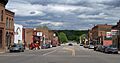
A view of Henderson, Minnesota.
-

Map showing the location of Henderson within Sibley County.
See also
 In Spanish: Henderson (Minnesota) para niños
