High Hill, Missouri facts for kids
Quick facts for kids
High Hill, Missouri
|
|
|---|---|

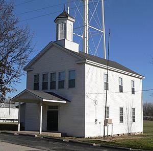
High Hill School
|
|

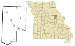
Location in Montgomery County and the state of Missouri
|
|
| Country | United States |
| State | Missouri |
| County | Montgomery |
| Area | |
| • Total | 0.46 sq mi (1.19 km2) |
| • Land | 0.46 sq mi (1.19 km2) |
| • Water | 0.00 sq mi (0.00 km2) |
| Elevation | 896 ft (273 m) |
| Population
(2020)
|
|
| • Total | 186 |
| • Density | 404.35/sq mi (156.27/km2) |
| Time zone | UTC-6 (Central (CST)) |
| • Summer (DST) | UTC-5 (CDT) |
| ZIP code |
63350
|
| Area code(s) | 636 |
| FIPS code | 29-31996 |
| GNIS feature ID | 2394374 |
High Hill is a small city in Montgomery County, Missouri, in the United States. In 2020, about 186 people lived there. The city gets its name because it is built on a high piece of land.
Contents
History of High Hill
High Hill has had a post office since 1837. A post office is where you can send and receive mail. The town was named "High Hill" because it is located on a high point of land.
Two important buildings in High Hill are listed on the National Register of Historic Places. These are the Farmers Mercantile Co. Building and the High Hill School. Being on this list means they are special places that are worth protecting.
Geography and Location
High Hill is located in the eastern part of Montgomery County. It is right next to Interstate 70, which is a major highway. You can get to High Hill from the highway using Highway F.
- Interstate 70 goes west about 4 miles (6.4 km) to New Florence.
- It goes east about 5 miles (8 km) to Jonesburg.
- The big city of St. Louis is about 75 miles (121 km) to the east.
- Columbia is about 55 miles (89 km) to the west.
The Norfolk Southern Railway also runs through High Hill. This railway goes east to St. Louis and northwest to Moberly and then to Kansas City.
Land and Water Around High Hill
High Hill covers an area of about 0.46 square miles (1.19 square kilometers). All of this area is land. The city sits on a ridge, which is a long, narrow hilltop.
Water flows from this ridge in two directions:
- North, towards Bear Creek. This creek is a "tributary," meaning it flows into a larger river called the West Fork of the Cuivre River. The Cuivre River then flows east into the Mississippi River.
- South, towards a different Bear Creek. This creek is a tributary of the Loutre River. The Loutre River then flows south into the Missouri River.
Population Changes Over Time
| Historical population | |||
|---|---|---|---|
| Census | Pop. | %± | |
| 1880 | 223 | — | |
| 1920 | 253 | — | |
| 1930 | 244 | −3.6% | |
| 1940 | 188 | −23.0% | |
| 1950 | 224 | 19.1% | |
| 1960 | 173 | −22.8% | |
| 1970 | 192 | 11.0% | |
| 1980 | 254 | 32.3% | |
| 1990 | 204 | −19.7% | |
| 2000 | 231 | 13.2% | |
| 2010 | 195 | −15.6% | |
| 2020 | 186 | −4.6% | |
| U.S. Decennial Census | |||
The table above shows how the number of people living in High Hill has changed over many years. This information comes from the U.S. Census, which counts everyone in the country every ten years.
High Hill in 2010
In 2010, the city of High Hill had 195 people living there. These people lived in 85 different homes, called "households." About 51 of these households were "families."
The city had about 424 people per square mile (164 people per square kilometer). Most of the people living in High Hill were White (95.9%). A small number were Native American (1.0%) or Asian (2.1%).
About 28% of the homes had children under 18 living in them. Many homes (48%) had married couples living together. The average age of people in High Hill was about 44 years old.
- About 20% of residents were under 18.
- About 25% were between 25 and 44 years old.
- About 21% were 65 years old or older.
There were slightly more males (51.3%) than females (48.7%) in High Hill in 2010.
See also
 In Spanish: High Hill (Misuri) para niños
 | Precious Adams |
 | Lauren Anderson |
 | Janet Collins |

