Higley, Arizona facts for kids
Quick facts for kids
Higley, Arizona
|
|
|---|---|

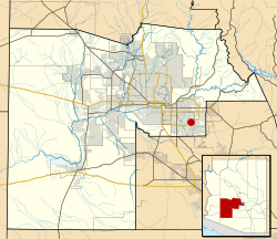
Location of Higley in Maricopa County, shown within corporate limits of Gilbert
|
|
| Country | United States |
| State | Arizona |
| County | Maricopa |
| Time zone | UTC-7 (Mountain (MST)) |
Higley was a small community in Maricopa County, Arizona, United States. It was known as an unincorporated area, meaning it didn't have its own city government.
Higley used to have its own ZIP code, 85236, until 2007. After that, the U.S. Postal Service changed things. Now, the 85236 ZIP code is only used for P.O. Box addresses at the Higley post office. This post office is located on Ray Road.
By 2010, most of Higley had become part of nearby cities. These cities include Gilbert, Mesa, and Queen Creek. Today, the main part of Higley that still exists on its own is the Higley Unified School District. Some old buildings in the original town area are still used by small businesses.
Where Was Higley Located?
Higley was found at specific geographic coordinates: 33.30729 degrees North and 111.720314 degrees West. This area is near the intersection of Higley Road and Williams Field Road. The very first part of the town was on the southwest corner of this intersection.
The Story of Higley's Beginning
Higley got its name from Stephen Weaver Higley. He was one of the first people to own land in the community. The town started with a piece of land about 40 acres (160,000 square meters) big. This land was bought between 1905 and 1906. The town's layout, or plat, was officially planned in 1928.
 | James Van Der Zee |
 | Alma Thomas |
 | Ellis Wilson |
 | Margaret Taylor-Burroughs |

