
Hillsdale, New South Wales facts for kids
Quick facts for kids HillsdaleSydney, New South Wales |
|||||||||||||||
|---|---|---|---|---|---|---|---|---|---|---|---|---|---|---|---|

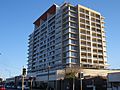
View of Hillsdale from Eastgardens Shopping Centre
|
|||||||||||||||
| Population | 5,501 (2016 census) | ||||||||||||||
| • Density | 7,900/km2 (20,000/sq mi) | ||||||||||||||
| Postcode(s) | 2036 | ||||||||||||||
| Area | 0.7 km2 (0.3 sq mi) | ||||||||||||||
| Location | 6 km (4 mi) south-east of Sydney CBD | ||||||||||||||
| LGA(s) | Bayside Council | ||||||||||||||
| State electorate(s) | Maroubra | ||||||||||||||
| Federal Division(s) | Kingsford Smith | ||||||||||||||
|
|||||||||||||||
Hillsdale is a suburb located in the Eastern Suburbs of Sydney, Australia. It's about 6 kilometres south-east of Sydney's city centre. The suburb is part of the Bayside Council area. Hillsdale was named after Pat Hills, who was a very important politician in New South Wales.
Contents
Shopping and Services in Hillsdale
Hillsdale has a main shopping area called Southpoint Shopping Centre. You can find it on Bunnerong Road. This centre used to be known as Hillsdale Town Centre.
Southpoint is a tall building with shops and homes. It has popular stores like TK Maxx, Aldi, and Woolworths. There is also a large Australia Post office there.
Fun and Sports at Heffron Park
Right across from Southpoint Shopping Centre is a huge park called Heffron Park. It's 44 hectares big, which makes it the largest sports park in Randwick City.
Many different sports are played here all year round. You can find people playing netball, rugby league, soccer, and cricket. There are also areas for cycling, tennis, and gymnastics.
At the south-east side of the park, you'll find the Des Renford Leisure Centre. This is a gym and swimming centre run by the local council. The park is also a great place for walking, jogging, and cycling.
The Hensley Athletic Field is another sports area nearby. It's located on Wentworth Avenue.
A Look Back at Hillsdale's History
Hillsdale used to be part of the suburb of Matraville until the 1960s. Matraville was first set aside to help fund churches and schools. Later, it became a place for soldiers returning from World War I to settle down.
In 1961, there was a problem because Matraville was split between two different councils. The Botany Council decided to rename its part "Gilmore" to honour an Australian poet, Dame Mary Gilmore. However, there was already a town called Gilmore in New South Wales.
So, the council chose "Hillsdale" instead. This was to honour Patrick Darcy Hills, who was a state minister. Some people didn't like the name choice. They felt it should have been a name that reflected Australia's history more.
Many homes were built in Hillsdale after World War II. Some of these were built by the Housing Commission to provide homes for people.
Who Lives in Hillsdale?
In 2016, there were 5,501 people living in Hillsdale. Most people (39.9%) were born in Australia. Other common countries of birth included Bangladesh, China, and the Philippines.
About 39.6% of people spoke only English at home. Many other languages are spoken too, like Bengali, Spanish, and Mandarin.
When it comes to religion, many people are Catholic (26.5%). A good number of people also said they had no religion (20.7%) or were Muslim (11.6%).
Most homes in Hillsdale are units or apartments. There are not many separate houses.
Learning at Matraville Public School
Matraville Public School is a primary school located in Hillsdale. It teaches students from kindergarten to Year 6. Most students come from Hillsdale, Banksmeadow, and Matraville.
The school first opened in 1903 as Cross Road Public School. It was named after its location at the corner of Beauchamp and Bunnerong Roads. In 1904, its name was changed to Matraville Public School.
Homes in Hillsdale
Most homes in Hillsdale are units or flats, not separate houses. More than half of the households in Hillsdale rent their homes. This is much higher than the average for Sydney.
About 2% of the homes in Hillsdale are public housing. This means they are provided by the government.
Getting Around Hillsdale
Hillsdale has several bus stops that help people travel around. The closest train station is the Domestic Airport railway station in Mascot. It is about 5 kilometres away.
The nearest light rail stop is the Juniors Kingsford stop in Kingsford. This is about 3.3 kilometres from Hillsdale.
Images for kids
-
Southpoint Shopping Centre, Bunnerong Road
-
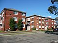
Characteristic three-storey blocks of home units, Unsted Crescent
-
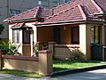
Characteristic detached cottage, Rhodes Street


