
Hirta facts for kids
|
||||||||||||||||||||||||||||||||

Hirta (Scottish Gaelic: Hiort) is the biggest island in the St Kilda group, found way out west in Scotland. Sometimes, the names Hiort (in Scottish Gaelic) and Hirta (in English) were used for the whole group of islands.
This island no longer has people living on it all the time. In the late 1600s, about 180 people lived on Hirta. By 1851, there were 112 residents. The last 36 people left in 1930 and moved to Lochaline on the Scottish mainland.
The National Trust for Scotland now owns all of the St Kilda islands. In 1986, St Kilda became one of Scotland's six World Heritage Sites. It's special because it's recognized for both its amazing nature and its unique history. Visitors can come to the island during certain months when tourist facilities are open.
Contents
Exploring Hirta's Landscape
Hirta is about 3.4 kilometres (2+1⁄8 miles) long from east to west. It is also about 3.3 km (2+1⁄16 mi) wide from north to south. The island covers an area of 6.285 km2 (2+7⁄16 sq mi). It has about 15 km (9 mi) of coastline.
The best place to land on Hirta is in Village Bay. This bay is on the southeast side of the island and offers good shelter. Another possible landing spot is Glen Bay, on the north coast. However, it's much harder to land there if the sea is rough. Most of Hirta's coastline has steep cliffs that drop straight into the deep ocean.
The highest point on Hirta is Conachair, which is 430 m high (1,410 ft). This peak forms a huge cliff on the northeast side of the island. St Kilda was likely formed by an ancient volcano.
Nearby Islands and Stacks
Dùn is another island very close to Hirta. A narrow stretch of water, called Caolas an Dùin, separates them. This strait is about 50 metres (55 yards) wide. It's usually too deep to cross, but people say it sometimes dries out.
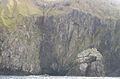
Hirta is also surrounded by many small rocky stacks. These are tall, thin rock formations sticking out of the sea. Some of these stacks include Bradastac, Mina Stac, and Sgeir Domhnuill. They are found near the cliffs of Conachair. Further south, near Osieval, is Sgeir nan Sgarbh.
Other stacks like An Torc and Sgeir Mhòr are located on the western and northern sides of Hirta. There are also large stacks in the narrow water between Hirta and Soay. These include Stac Dona, Stac Soay, and Stac Biorach.
What Does "Hirta" Mean?
The name Hirta has a mysterious origin. Some people think it comes from an Irish word, Ier, meaning "west." Others suggest it might be from a Celtic word meaning "gloom" or "death."
Another idea is that it comes from the Scottish Gaelic phrase hIar-Tìr, which means "westland." An old Icelandic story from the 1200s mentions islands called "Hirtir." This might mean the island's shape looked like a stag (a male deer), as hirtir means "stags" in Norse.
Some believe the name comes from the Gaelic Ì Àrd, meaning "high island." Or perhaps from the Norse word hirt, meaning "shepherd." Another Norse idea is Hirðö, meaning "herd island."
Life on Hirta Through History
People have lived on the St Kilda islands for a very long time. Archeologists found proof that people lived there at least 2,000 years ago. They discovered pottery from the Iron Age and possibly even the Bronze Age. This shows that Village Bay was a busy place during the Iron Age.
Hirta was continuously lived on until August 29, 1930. On that day, the last 36 islanders moved to the Scottish mainland. They asked to leave because life on the island had become too difficult.
St Kilda was once part of the Lord of the Isles' lands. From 1498 until 1930, it belonged to the MacLeods of Dunvegan. There were three small churches on St Kilda, but not much of them remains today. You can also find the ruins of a special round stone house called the Amazon's House.
A Tough Island Life
The people of St Kilda had a very hard life. They survived by using the thousands of seabirds that lived on the islands. They ate oatmeal, salted birds, and seabird eggs in summer. In winter, they ate salted mutton. They got tea, sugar, flour, and tobacco from visitors and the island owner's agent. Fresh water came from natural springs. They rarely had fruits or vegetables, except for some poor-quality potatoes.
In the 1830s, the island's landlord and a minister named Rev. Neil MacKenzie tried to improve the houses. The old village on the hill was replaced by new "blackhouses" in a curved shape. These were damaged by a storm. In 1861, 16 new houses were built to replace them.
Missionaries taught the children for many years. By 1872, the government took over education. Eventually, a proper school building was built.
A school teacher's diary from the early 1900s gives us a peek into island life. At that time, St Kilda was quite lively. It had a good tourist trade and a strong market for the island's tweed fabric. Whaling boats brought coal. The government provided more services, like visiting doctors who gave vaccinations. English fishing fleets often visited, connecting the islanders to the outside world more than ever.
Medical care was always limited. In the late 1890s, only one nurse was on the island with few supplies. This improved in 1915 when more medical staff arrived.
Documentary films also showed life on Hirta. In 1908, British Pathé News released "The Island Of St. Kilda." Another film, "St Kilda, Britain's Loneliest Isle," was made in 1923 and released in 1928. It showed a journey from Glasgow to St Kilda and scenes of island life.
Population Changes
The number of people living on St Kilda changed a lot over time.
- In 1764, there were 90 St Kildans.
- By 1841, the population grew to 105.
- In 1851, it reached 112.
- The next year, 36 people left to live in Australia.
- By 1861, the population dropped to 71.
- In 1911, it was 74.
- By 1927, only 43 people remained.
- In 1930, just before the evacuation, there were 36 residents.
World War I and Its Impact
During the First World War, the Royal Navy built a signal station on Hirta. This allowed the island to communicate with the mainland every day for the first time.
On May 15, 1918, a German submarine, SM U-90, arrived in Village Bay. After warning the islanders, it started shelling the island. The wireless station was destroyed. The church, minister's house, and a storage building were damaged. Luckily, no one was hurt.
The war actually brought some good things to the island. A naval group arrived, bringing regular mail and food supplies. But when the war ended, these services stopped. The islanders felt more isolated than ever. Young, strong islanders left to find better lives, which hurt the island's economy.
The Evacuation of 1930
Before the evacuation in 1930, 36 people lived on Hirta: 13 men, 10 women, 8 girls, and 5 boys. They lived in 10 rented cottages.
The resident nurse, Williamina Barclay, was very worried about the islanders' health. Especially after two young women died, she encouraged them to leave. On May 10, 1930, most islanders signed a paper saying they couldn't stay another winter. The local missionary and schoolteacher, Dugald Munro, and Nurse Barclay supported the plan.
The evacuation happened on August 29, 1930. The ship HMS Harebell took the islanders to Lochaline, on the Scottish mainland. It was a beautiful day, making it even harder to leave. Following tradition, the islanders left an open Bible and a small pile of oats in each house. They locked their doors and boarded the ship at 7 AM. Even though they were tired, they stayed cheerful. But as the island disappeared from view, they began to cry.
A film made in the summer of 1930 shows scenes of the preparations and the evacuation. You can watch it on the National Library of Scotland's website.
After the evacuation, the men found work in forestry. Most families settled near Lochaline. Others moved to places like Strome Ferry, Culcabock, and Culross.
In 1931, Sir Reginald MacLeod of MacLeod sold St Kilda to the Earl of Dumfries. He later gave it to the National Trust for Scotland in 1957. St Kilda became Scotland's first World Heritage Site in 1987.
Military Presence on Hirta
In 1955, the British government decided to use St Kilda for a missile tracking range. This range was based in Benbecula. Military buildings and masts were built on Hirta, including a canteen called the Puff Inn. Some military workers live on the island all year round. The Ministry of Defence (MoD) rents St Kilda from the National Trust for Scotland for a small fee.
In 2018, the MoD facilities were being updated. This included replacing old generators and living quarters. The island's population, which is not permanent, can change from 20 to 70 people. These include MoD staff, National Trust for Scotland workers, and scientists studying the Soay sheep.
Visiting Hirta Today
Tourists started visiting Hirta often in the 1870s. Steamships and private yachts began to arrive. A new pier was built in 1901. This made it easier for larger boats to drop off passengers using smaller rowboats.
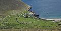
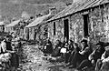
You can still see the remains of the homes built in the 1860s in Village Bay. This area is also known as St Kilda Village. The ruins of three old chapels are also visible. When facilities are open, visitors can explore the St Kilda museum, school, and church. These places offer a great look into how the St Kildans lived. You can also see the remains of the village, the graveyard, and a World War I gun.
The church, with a schoolroom added in 1898, has been restored to look like it did in the 1920s. The village houses are arranged along a curved street. This layout was part of improvements made in the mid-1800s.
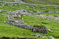
You'll also see many unique stone storage buildings called cleitan (singular: cleit). These small stone buildings had thatched roofs. Islanders used them to dry and store food. There are over 1,400 cleitan across the St Kilda islands, but most are found near the village.
The National Trust for Scotland has worked to improve the Village. They have put new roofs on some cottages and restored the church. They have also rebuilt stones that fell from the cleitan due to strong winds. One cottage, number 3 on "The Street," was fully restored and turned into the museum.
Many tour operators offer boat trips to the island during the summer.
See also
- List of islands of Scotland
- List of outlying islands of Scotland
- Taraxacum pankhurstianum, the St Kilda dandelion
Images for kids
-
Overview of Village Bay
-
Bradastac
-
Abandoned homes on Hirta, built in the 1860s
-
The Street, Village Bay (St Kilda Village), 1886
-
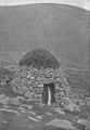
A cleit, used for storing and drying food; 1898 photo
-
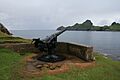
The 4-inch QF gun on Hirta looking towards Dùn
-
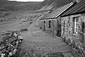
Abandoned Village Bay homes, Hirta, June 2007
-
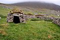
A cleit (storage shed); 2009


