History of Saskatoon facts for kids
The history of Saskatoon began in 1883. That's when the first non-Indigenous settlers arrived. These were Toronto Methodists who wanted to create a "dry" community. This meant a place where alcohol was not allowed. They chose this area in the growing prairie region.
In 1882, this land was part of the Saskatchewan area. The Temperance Colonization Society looked at the area in 1882. They thought it was a great spot for their community. Saskatoon often celebrates 1882 as its founding year.
The settlers were led by John Neilson Lake. They traveled by train from Ontario to Moose Jaw. Then, they finished their journey to Saskatoon by horse-drawn cart. The railway had not yet reached Saskatoon. The plan for the Temperance Colony didn't fully work out. They couldn't get a large piece of land together. Still, John Lake is known as the founder of Saskatoon. A school, a park, and two streets are named after him.
In 1885, during the North-West Rebellion, some houses on 11th Street East became military hospitals. One of these, the Marr Residence, is now a special heritage site. The first school, Victoria School, opened in 1888. This small school, now called the "Little Stone Schoolhouse", is on the University of Saskatchewan campus today.
Contents
Early History of Saskatoon
Before the city was founded, the Saskatoon area was home to Indigenous peoples. The oldest signs of people living here are from about 6,000 years ago. Evidence shows that Indigenous peoples lived here in winter. The land where Saskatoon now stands was given to the Crown by Treaty 6 in 1876.
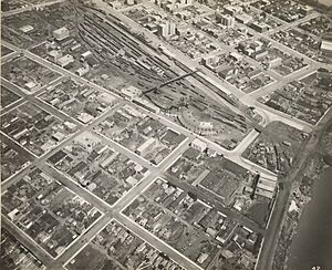
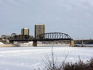
The Qu'Appelle, Long Lake and Saskatchewan Railway reached Saskatoon in 1890. It crossed the South Saskatchewan River where the Senator Sid Buckwold Bridge is now. This railway arrival caused a lot of growth on the west side of the river.
Saskatoon in the 20th Century
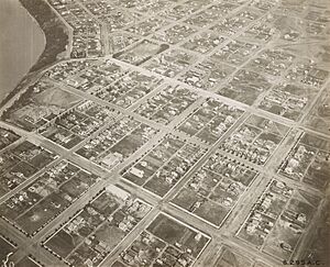
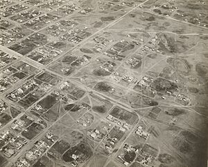
From 1895 to 1913, Saskatoon grew very fast. It was a "boomtown." Many things helped this growth. These included the temperance settlement and an economic boost from the Barr colonists in 1903. Saskatoon also became a major railway hub in western Canada. The University of Saskatchewan was also built here.
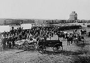
In 1901, Saskatoon's population was 113 people. A third settlement, Riversdale, started southwest of Saskatoon. In 1903, Saskatoon's economy boomed. This happened when the Barr colonists camped in the city. They were on their way to the Brittania colony. The west side of the river became a town in 1903. Nutana also became a village that year.
In April 1904, the rail bridge collapsed. This was due to melting ice on the South Saskatchewan River. Saskatoon's leaders worked to make the city important for railways. Their efforts led to Saskatoon becoming a major railway center. Both the Canadian Pacific Railway and the Grand Trunk Pacific Railway built bridges near the town by 1907. The QLL&SR bridge was rebuilt in 1905. It was taken down in 1965 for new roads and a bridge.
In 1906, Saskatoon officially became a city. It had a population of 4,500 people. This included the communities of Saskatoon, Riversdale, and Nutana.
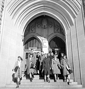
After the Province of Saskatchewan was formed in 1905, leaders wanted to create a university. Many cities were considered. On April 7, 1907, Saskatoon was chosen for the University of Saskatchewan.
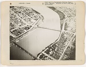
By 1907, several important bridges were finished. These included the Traffic Bridge, the CPR Bridge, and the Grand Trunk Pacific GTP Railway Bridge. The Traffic Bridge helped connect Nutana and West Saskatoon across the South Saskatchewan River. Road underpasses and a pedestrian bridge were built to help people cross the railway lines.
Later 20th Century Growth
After World War I, the "Dirty Thirties" and the Depression hit. Many people left their farms. They hoped to find jobs in cities like Saskatoon. World War II also changed things. More people moved from rural areas to cities. Saskatoon became a major center for the British Commonwealth Air Training Plan in the 1940s. It also became a key place for distributing goods and services. From 1945 to 1960, Saskatoon had a big shortage of homes.
In the 1960s, the CNR rail yards moved. This made space for the Idylwyld Freeway and Midtown Plaza. This was part of a big project to improve downtown Saskatoon.
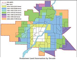
Saskatoon's original city limits were set in 1906. These stayed mostly the same for about 40 years. The city grew a lot after World War II. New neighborhoods were built between 1940 and 1980. These included areas like Nutana, Confederation, and Lawson.
In 1955, Montgomery Place joined Saskatoon. In 1956, the nearby town of Sutherland also became part of the city. This growth continued until the mid-1980s. Saskatoon also expanded its technology, education, and culture to meet the needs of its growing population.
Saskatoon in the 21st Century
Saskatoon's first big growth earned it the nickname "Hub City." Its recent growth has been called "Sask-a-boom." The city government is now focused on improving its infrastructure. This means building new roads, bridges, and other services. These are needed for the growing population and physical size of the city.
The city's retail sector has grown a lot. Many new neighborhoods and communities are being built. This means the city needs more fire halls, buses, police stations, and libraries. It also needs more water and power plants, bridges, and roads. Many new areas like Rosewood, Stonebridge, and Hampton Village are being developed.
In July 2010, Saskatoon expanded even more. It added large areas to the north, northeast, and east.
On August 24, 2010, the Traffic Bridge was closed. It was unsafe. This bridge was a symbol of Saskatoon, Nutana, and Riversdale joining together. In 2011, the city decided to replace it. The new bridge opened on October 3, 2018.
Communities That Became Part of Saskatoon
| Areas Added to Saskatoon by Year, 1911–2005 | |||
|---|---|---|---|
| 1911 | Adelaide Avalon Exhibition |
Grosvenor Park Holliston Mayfair |
Mount Royal East North Park Nutana Park Pleasant Hill Varsity View Westview |
| 1955–59 | Brevoort Park College Park Eastview Forest Grove |
Greystone Heights Hudson Bay Industrial Meadow Green |
Montgomery Place Mount Royal West Richmond Heights River Heights 1 |
| 1960–64 | C.N. Industrial 1 Massey Place |
Confederation Suburban Ctr. Westview |
Fairhaven |
| 1965–69 | Airport Industrial | C.N. Industrial 2 | South Nutana Park |
| 1970–74 | Airport Confederation |
Fairhaven Pacific Heights |
Wildwood |
| 1975–79 | Briarwood Dundonald |
Hudson Bay Ind. Lakeridge |
Lawson Heights Marquis Industrial |
| 1980–84 | Agriplace Arbor Creek |
Erindale<
Marquis Industrial |
Willowgrove Lakewood SDA |
| 1985–89 | Stonebridge | ||
| 1990–94 | Marquis Industrial | ||
| 2000–04 | Hampton Village | Willows | University Heights SDA |
| 2005 | Blairmore | Marquis Industrial (Akzo) | |
Saskatoon became a city by joining with three main communities. But over time, it has grown to include many other early settlements.
- North Saskatoon is now called North Park.
- West Saskatoon was a post office in 1900. It changed its name to Saskatoon in 1902. This area is now the Central Business District.
- Chappell was a train station west of Saskatoon. It was near where Montgomery Place is today.
- There was also a community called Brownell. It was near what is now 51st Street and Miners Avenue. This is in the Hudson Bay Industrial neighborhood.
- McNab Park was built in 1967 as a Royal Canadian Air Force station. It is in the Airport Business Area. It was used for low-income housing for many years. The community was taken down in 2011–2012. It is now being redeveloped into a business park.
- The "Magic City" of Factoria is now the neighborhood of Silverwood Heights. A man named Billy Silverwood owned land north of Saskatoon. He bred horses and bottled spring water. An entrepreneur from Chicago, R.E. Glass, bought Silverwood Bottling Company. He dreamed of an industrial community with factories and breweries. The railway came in 1913, and some businesses started. But World War I and the arrival of electricity made the plan fail.
- Caswell Hill was a hill on Robert Caswell's land. It became Saskatoon's first suburb. You can see it in old photos of west Saskatoon.
- Crescent Heights was a planned subdivision from 1912. It was meant to be five miles (8 km) from Saskatoon's city limits. This area is still outside the city today.
- West of Saskatoon, there were several train stations close together. These included Yorath, Garfield, Cory, Farley, and Eaton. Eaton was later renamed Hawker. It is now the home of the Saskatchewan Railway Museum. Eaton was also used as a Ukrainian Canadian internment camp during World War I.
- Smithville Cemetery is just west of Saskatoon on Highway 14. It is now inside the city limits.
- East of Saskatoon, there were train stations like Newcross (later called South Saskatoon) and Duro. Engen and Floral were also east of Saskatoon.
- In 1904, the Grand Trunk Railway built a station called Earl. It was three miles (5 km) south of Saskatoon's limits at the time. This area is now the CN Industrial area.
Historical Population Growth of Saskatoon
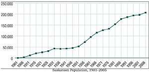
| How Saskatoon's Population Changed | |||
|---|---|---|---|
| 1901–2016 | |||
| Census Year | Population | Population Change |
5-year Change |
| 1901 | 311 | ||
| 1906 | 3,011 | 2,700 | 868% |
| 1911 | 12,004 | 8,993 | 299% |
| 1916 | 21,054 | 9,050 | 75% |
| 1921 | 25,739 | 4,685 | 22% |
| 1926 | 31,234 | 5,495 | 21% |
| 1931 | 43,291 | 12,057 | 39% |
| 1936 | 41,734 | (1,557) | −4% |
| 1941 | 43,027 | 1,293 | 3% |
| 1946 | 46,028 | 3,001 | 7% |
| 1951 | 53,268 | 7,240 | 16% |
| 1956 | 72,858 | 19,590 | 37% |
| 1961 | 95,526 | 22,668 | 31% |
| 1966 | 115,247 | 19,721 | 21% |
| 1971 | 126,450 | 11,203 | 10% |
| 1976 | 133,750 | 7,300 | 6% |
| 1981 | 154,210 | 20,460 | 15% |
| 1986 | 177,641 | 23,431 | 15% |
| 1991 | 186,058 | 8,417 | 4.74% |
| 1996 | 193,647 | 7,589 | 4% |
| 2001 | 196,811 | 3,164 | 2% |
| 2006* | 206,500 | 9,689 | 5% |
| 2011* | 222,245 | 15,745 | 7.6% |
| 2016* | 246,376 | 34,131 | 10.9% |
| *These numbers are from their respective censuses | |||
 | Claudette Colvin |
 | Myrlie Evers-Williams |
 | Alberta Odell Jones |


