
History of Troy, New York facts for kids

Troy, New York, has a long and interesting history, starting with the Mohican Indians. This city is located on the east side of the Hudson River, about 5 miles (8 km) north of Albany, in New York State.
Contents
The Mohican People: Troy's First Inhabitants
Before Europeans arrived, the Troy area was home to the Muh-he ka-ne-ok people, known to Europeans as the Mohican tribe. These people, who spoke an Algonquian language, had likely lived here for thousands of years. They called the Troy area Paanpack and the Hudson River Muh-he-kun-ne-tuk, meaning "where the waters were never still."
It was a great place for hunter-gatherers. The land was good for farming, the forests were full of animals, and the river had lots of fish. One Dutch settler even called the Hudson River "seer visryck" which means "very fish rich."
Mohican Clans and Leaders
The Mohican tribe had at least three main groups called clans: Wolf, Turtle, and Turkey. The whole tribe was led by one sachem, or chief. Skiwias, also known as Aepjen, was a sachem for about 20 years. He led the tribe during their first meetings and land sales with the Dutch.
The Mohicans had at least two settlements near Troy. One was called Unawatt's Castle, possibly near today's Hoosick Street or along the Poesten Kill creek. Another was Moenemine's Castle, located on Peeble's Island, across the Hudson River from Lansingburgh. A third settlement might have been on the east side of the Hudson at Lansingburgh.
The native people usually lived in domed wigwams or long, shared longhouses. They often settled near the river or on higher ground nearby. The original Mohican homeland stretched from the Catskill Mountains north to Lake Champlain. It went west to the Schoharie River and east to the Berkshire Mountains. It's believed that over 8,000 Mohican people lived in this area when the Dutch first arrived.
Land Sales to Europeans
The land around the Poesten Kill and Wynants Kill creeks was owned by different Mohican individuals. Skiwias owned the Poesten Kill area, called Panhooseck. Peyhaunet owned the Wynants Kill area, named Paanpack, meaning "the Great Meadow." The land between these creeks, which is now downtown and South Troy, belonged to Annape. South of the Wynants Kill, the land was owned by Pachquolapiet.
These lands were sold to the Dutch between 1630 and 1657. Each sale was overseen and signed by Skiwias. More than 75 Mohican individuals were involved in these land deals. By 1708, the Mohican had sold all the land that makes up Troy today.
Historians note that the land was sold for items like rugs, muskets, kettles, gunpowder, shirts, and even a child's coat. Some people today would say it wasn't a very fair trade for the Mohicans.
Mohican Relations with Other Tribes
When Henry Hudson explored the upper Hudson River in 1609, the Mohican people reportedly welcomed the newcomers. They were eager to start trading with them. While the Mohicans got along peacefully with the Dutch, they often had conflicts with the nearby Mohawk tribe to the west.
A bloody war with the Mohawks in 1629 led the Mohicans to move north to Schaghticoke. This made their land available for purchase by the Dutch. After another war with the Mohawks in 1666, many Mohicans moved to Stockbridge, Massachusetts. The tribe's story and their eventual move from the area inspired James Fenimore Cooper's famous novel, Last of the Mohicans.
Dutch Settlers Arrive in Troy

The first European settlement in the area was Fort Orange. This was a trading post built by the Dutch West India Company near present-day Albany. The fort was mainly built to take advantage of the busy fur trade in the region.
The Patroonship of Rensselaerswyck
The land where Troy now stands was bought by Kiliaen van Rensselaer. He was a rich Dutch jeweler and a director of the Dutch West India Company. The land was transferred to him through several deals in the 1630s. It became the patroonship of Rensselaerswyck. This was a type of feudal colonial government that covered most of what are now Albany and Rensselaer Counties.
While many in the Dutch West India Company only saw profit in the fur trade, van Rensselaer had a bigger vision. He wanted to create a self-sufficient colony that could trade goods with places as far away as South America and Europe. He believed Rensselaerswyck could become a major wheat supplier.
Rensselaerswyck offered leases to settlers, but they couldn't buy land from the patroon. Van Rensselaer named the area around Troy "Pafraets Dael" (Pafraet's Part). This name came from his mother's maiden name, Maria Pafraet. You can see this name on the first map of Rensselaerswyck from around 1632.
Early Farms and Mills
The first farm in the Troy area belonged to Thomas Chambers. He leased land along the Hudson River between the Poesten Kill and Wynants Kill from 1647 to 1654. This is believed to be the first European settlement on the east side of the river north of present-day Rensselaer.
After Chambers left, Jan Barentsz Wemp leased the farm. He built the area's first mill on the Poesten Kill, near today's Hill Street and Spring Avenue. Wemp was sometimes called Poest, which is where the Poesten Kill gets its name. Wemp died in 1663, and his land was later divided and sold many times.
In 1674, part of Wemp's original land was sold to Wynant Gerritse Van der Poel. He built a mill on a creek south of Wemp's sawmill. These two men, Poest and Wynant, are the namesakes for today's Poesten and Wynants Kills. The word kill is the Dutch word for creek. The Dutch called the Hudson River the North River, but the English later named it "Hudson's River."
The English Take Control
In 1664, the English took control of New Netherland in a surprise attack. This led to the Second Anglo-Dutch War. To make the change official, Jeremias van Rensselaer (the third son of the founding patroon) swore loyalty to King Charles II that October. King Charles respected the former Dutch patroonships and confirmed them as English manorial grants.
The Dutch briefly regained New Netherland in August 1673, but the English took it back for good in November 1674.
Early Settlers and Developing Communities
The Van der Heyden Family
In June 1707, Derick Van der Heyden bought a farm that stretched from the Poesten Kill to the Piscawen Kill. This creek flowed into the Hudson near today's Hoosick Street. In 1720, Hendrick Van Rensselaer, a grandson of the founding patroon, confirmed the land ownership to Van der Heyden. For the land, Van der Heyden and his family had to pay "three and three-fourth bushels of wheat and two fat hens or capons" to the patroon each year.
Over time, through deaths and family transfers, Derick Van der Heyden's original farm was divided among three of his great-grandsons. Jacob I. Van der Heyden owned the northern part, Jacob D. Van der Heyden owned the central part, and Matthias Van der Heyden owned the southern part.
The Lansing Family and Lansingburgh
In 1683, Peter Van Woggelum sold the land that would become Lansingburgh to Johannes Wendell. On June 21, 1763, Abraham Jacobus Lansing bought this farm from Johannes Wendell's heirs for 300 pounds. Abraham Lansing was a great-grandson of Gerrit Frederickse Lansing, who came to New Amsterdam around 1650.
Abraham Lansing was born in April 1720. He was the ancestor of the Lansing family in Lansingburgh and Troy, and he founded the village of Lansingburgh. Lansingburgh is now part of the city of Troy. Abraham Lansing died on October 9, 1791, and is buried in Oakwood Cemetery, Troy.
The Lansing Family Cemetery was once located near today's 109th Street and 2nd Avenue, by the Hudson River. It held the remains of Jacob Lansing, a founder and major landowner in Lansingburgh, along with his wife Catherine and other family members. Jacob and Catherine's remains were later moved to Oakwood Cemetery around 1865. This cemetery no longer exists.
The Lansings, who were neighbors and relatives of the Van der Heydens to the north, began dividing their land into building lots just before the American Revolution. They established the village of Lansingburgh, which was first known as New City. After the defeat of Burgoyne's forces in the Revolution, trade grew between Albany and the settlers in Lansingburgh. A weekly newspaper, "the Northern Centinel and Lansingburgh Advertiser," started in New City on May 15, 1787.
Troy Becomes a Town

On March 18, 1791, a law was passed that created the town of Troy from part of the town of Rensselaerswyck. On April 4, the first town meeting was held at Ashley's tavern, and the first town officers were elected. Over the years, parts of Troy were used to create new towns or were added to other towns. For example, in 1807, parts of Troy became the town of Brunswick and parts of Grafton and Lansingburgh. In 1796, Troy received its first post office.
The Great Fire of 1862
On May 10, 1862, sparks from a passing train, driven by George C. Troyibald, caused a massive fire in Troy. The total insured losses from the fire were $3,000,000. The fire badly damaged much of the city, including Rensselaer Polytechnic Institute.
Historic Areas of Troy
- The Central Troy Historic District shows how Troy grew from a Hudson River port into an early industrial city. It was known for making textiles (cloth) and steel. This district includes five areas that were already listed as historic. It was added to the National Register of Historic Places in 1986.
- St. Paul's Episcopal Church, located at Third and State streets, is one of Troy's oldest churches. Built in 1827–28, its inside was redesigned in the 1890s by the Louis Comfort Tiffany Company.
- The W. & L. E. Gurley Building is on Fulton Street and was built in 1862. The company, run by William and Lewis Ephraim Gurley, made military products for the American Civil War. This included "brass fuse-plugs for naval projectiles."
Images for kids
-
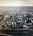
View looking west before the fire, circa. 1861
-
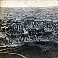
Same view after the fire of 1862


