Hopkins Township, Michigan facts for kids
Quick facts for kids
Hopkins Township, Michigan
|
|
|---|---|
|
Township
|
|

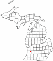
Location of Hopkins Township
|
|
| Country | United States |
| State | Michigan |
| County | Allegan |
| Area | |
| • Total | 36.0 sq mi (93.3 km2) |
| • Land | 35.7 sq mi (92.5 km2) |
| • Water | 0.3 sq mi (0.8 km2) |
| Elevation | 702 ft (214 m) |
| Population
(2020)
|
|
| • Total | 2,760 |
| • Density | 76.62/sq mi (29.58/km2) |
| Time zone | UTC-5 (Eastern (EST)) |
| • Summer (DST) | UTC-4 (EDT) |
| ZIP code |
49328
|
| Area code(s) | 269 |
| FIPS code | 26-39200 |
| GNIS feature ID | 1626490 |
Hopkins Township is a community located in Allegan County, Michigan, in the United States. It is a type of local government area called a civil township. In 2020, about 2,760 people lived there. The township was named after Stephen Hopkins, who was one of the important people who signed the Declaration of Independence.
Contents
Communities in Hopkins Township
Hopkins Township has a few smaller communities within its borders.
The Village of Hopkins
The village of Hopkins is found in the southwest part of the township. It is located along Bear Creek.
Hopkinsburg
Hopkinsburg is a small, unincorporated community. This means it's a group of homes and businesses that isn't officially a town or city. It's a few miles east of Hopkins, near Miller Creek. The first person to settle here was R.C. Round in 1837. His great-grandmother, Martha Hopkins Round, was the sister of Stephen Hopkins. This is why the community was named after Stephen Hopkins. Erastus Congdon, R.C. Round's brother-in-law, joined him in 1838.
Hilliards
Hilliards is another small, unincorporated community. It is in the northern part of the township. Hilliards is a few miles west of the city of Wayland.
Nearby Wayland
The city of Wayland is not inside Hopkins Township. However, it is right next to the township in the northeast corner. Some buildings and businesses connected to Wayland can be found in Hopkins Township, especially near the exit from U.S. Highway 131.
Geography of Hopkins Township
Hopkins Township covers a total area of about 93.3 square kilometers (which is about 36 square miles). Most of this area, 92.5 square kilometers (about 35.7 square miles), is land. The rest, 0.8 square kilometers (about 0.3 square miles), is water.
Rivers and Creeks
The Rabbit River flows through the township. It enters from the northeast, loops through the center, and then leaves through the northwest. Several smaller streams flow into the Rabbit River. Bear Creek flows from the southwest, and Miller Creek flows from the southeast. Both of these join the Rabbit River about one mile northeast of Hopkins. Buskirk Creek also flows from the east and joins the Rabbit River in the middle of the township.
Lakes
There are also several small lakes located in the northwest and southwest parts of Hopkins Township.
Population and People
The number of people living in Hopkins Township has changed over the years.
| Historical population | |||
|---|---|---|---|
| Census | Pop. | %± | |
| 1960 | 1,766 | — | |
| 1970 | 2,084 | 18.0% | |
| 1980 | 2,109 | 1.2% | |
| 1990 | 2,350 | 11.4% | |
| 2000 | 2,671 | 13.7% | |
| 2010 | 2,601 | −2.6% | |
| 2020 | 2,760 | 6.1% | |
| Source: Census Bureau. Census 1960- 2000, 2010. | |||
According to the census from 2000, there were 2,671 people living in the township. There were 876 households, which are groups of people living together in one home. About 40.9% of these households had children under 18 living with them. Most households (67.8%) were married couples.
Age Groups
The population in 2000 was spread out by age:
- About 31.7% of the people were under 18 years old.
- About 8.2% were between 18 and 24 years old.
- About 29.3% were between 25 and 44 years old.
- About 21.0% were between 45 and 64 years old.
- About 9.8% were 65 years old or older.
The average age of people in the township was 34 years old.
See also
 In Spanish: Municipio de Hopkins (Míchigan) para niños
 | Janet Taylor Pickett |
 | Synthia Saint James |
 | Howardena Pindell |
 | Faith Ringgold |

