
Howland and Baker Islands facts for kids
Howland Island and Baker Island are two small, empty U.S. islands in the Pacific Ocean. They are close to the Equator. Both islands are special places where wildlife is protected. Howland Island is the bigger of the two.
These islands are part of the United States Minor Outlying Islands. They also belong to a group of islands called the Phoenix Islands. The United States Fish and Wildlife Service looks after them as National Wildlife Refuges. In 2009, President George Bush made both islands part of the Pacific Remote Islands Marine National Monument.
The area around Howland and Baker Islands is a special protected zone called an Exclusive Economic Zone (EEZ). The United States Coast Guard helps protect this large area. The Howland-Baker EEZ is about 425,700 square kilometers. That's almost as big as the state of California!
Howland Island is famous because it was the place Amelia Earhart was trying to reach in 1937 when her plane disappeared. These islands are also unique because they are the only land in the world that uses UTC−12:00 time. This means they are the very last place on Earth to experience a new day.
Contents
Protecting the Ocean Around the Islands
The U.S. started creating these protected ocean zones, or EEZs, in 1976. In 1983, a special agreement called the Treaty of Tarawa was signed. This treaty set the ocean border between Baker Island and McKean Island, which belongs to Kiribati. The treaty helps both countries work together on fishing near their islands.
Since 2008, the Kiribati side of this border has been a marine protected area called the Phoenix Islands Protected Area. This shows how important it is to protect the ocean.
Island Size and Protected Areas
Howland and Baker Islands together are about 855 acres of land. No one lives on them. The islands are about 37 nautical miles (68 kilometers) apart.
If Howland and Baker had their own separate protected ocean zones, those zones would overlap a lot. But since they are combined into one large EEZ, it covers a huge area. This combined EEZ is about 4% of the total U.S. coastline. It's even bigger than the entire countries of South Korea or Cuba!
The Pacific Remote Islands Marine National Monument extends out 50 nautical miles (92 kilometers) from each island. The National Wildlife Refuge around each island goes out 12 nautical miles (22 kilometers).
How the Islands Were Formed
Howland and Baker islands are very old volcanoes, formed between 75 and 120 million years ago. Over time, coral grew on top of these volcanoes, creating the flat islands we see today. The ocean floor around them is very deep, usually more than 5,000 meters (16,400 feet). It's covered in deep-sea sediment.
Resources and Protection
The islands have some natural resources like phosphates, sand, gravel, and coral. They also have guano (bird droppings), which can be used as fertilizer. However, because these islands are protected wildlife refuges and part of a marine monument, no one is allowed to mine or fish there. All commercial activities are forbidden to keep the islands and their surrounding waters safe for wildlife.
Border with Kiribati
Howland and Baker Islands are considered part of the Phoenix Islands. Most of the other Phoenix Islands belong to Kiribati, a nearby country. The border between the Howland-Baker EEZ and Kiribati is halfway between Baker Island and McKean Island.
Kiribati's land stretches around Howland and Baker Islands. For example, while Winslow Reef in Kiribati is southeast of Howland and Baker, the capital of Kiribati, Tarawa, is about 625 nautical miles (1,157 kilometers) to the west of Howland.
In 2009, Kiribati asked the U.S. to join its Phoenix Islands Protected Area with the U.S. monument. This would create a huge protected ocean area. In 2014, the U.S. and Kiribati signed an agreement to work together. They plan to support research and conservation in both the U.S. Pacific Remote Islands Marine National Monument and Kiribati's Phoenix Islands Protected Area.
Protecting the Borders
The United States Coast Guard helps make sure no one fishes illegally in the protected EEZ. In 2005, the Coast Guard caught a large fishing boat that was just two miles from the border with Kiribati. The case went to court in Guam.
The Last Place on Earth
Because of their location, Howland and Baker islands are the last places in the U.S. to celebrate the New Year. They are in the UTC−12 time zone, which is 24 hours behind the Wake Island Time Zone.
These islands are also important for satellites. They are in the perfect spot above the Equator where satellites can stay in geosynchronous orbit. This means the satellites stay in the same spot in the sky. In 1964, the first geostationary satellite, Syncom 3, was placed near Howland Island. It was used to show live TV coverage of the 1964 Tokyo Summer Olympics.
Tsunami Warnings
The Pacific Tsunami Warning Center uses "Howland-Baker" as a warning point when they issue tsunami alerts.
The Story of the Island Colonists
The story of Howland and Baker Islands is also about brave people. In 1935, a few Hawaiians and military staff went to live on Jarvis, Howland, and Baker islands. This was done to claim the islands for the United States. President Franklin D. Roosevelt officially claimed them in May 1936.
A documentary called Under a Jarvis Moon tells the story of about 130 Americans who lived on these islands between 1935 and 1942. They stayed for shifts of 3 to 4 months. These settlers even helped prepare an airstrip for Amelia Earhart's famous flight.
Their time on the islands ended suddenly on December 8, 1941, the day after the attack on Pearl Harbor. Howland and Baker islands were bombed, and two of the four colonists on Howland died. The last colonists were removed from Jarvis, Howland, and Baker islands in February 1942.
Images for kids
-
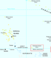
Location of the Howland and Baker Islands
.png)
