Huachuca City, Arizona facts for kids
Quick facts for kids
Huachuca City
|
||
|---|---|---|
| Huachuca City, Arizona | ||
|
||

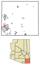
Location of Huachuca City in Cochise County, Arizona.
|
||
| Country | ||
| State | ||
| County | ||
| Incorporated | 1958 | |
| Area | ||
| • Total | 2.83 sq mi (7.32 km2) | |
| • Land | 2.83 sq mi (7.32 km2) | |
| • Water | 0.00 sq mi (0.00 km2) | |
| Elevation | 4,364 ft (1,330 m) | |
| Population
(2020)
|
||
| • Total | 1,626 | |
| • Density | 575.37/sq mi (222.12/km2) | |
| Time zone | UTC-7 (MST (no DST)) | |
| ZIP code |
85616
|
|
| Area code | 520 | |
| FIPS code | 04-34120 | |
| GNIS feature ID | 2412775 | |
| Website | Town of Huachuca City | |
Huachuca City is a small town in Cochise County, Arizona, United States. It is located in the southern part of the state. In 2020, about 1,626 people lived there.
A large U.S. Army base called Fort Huachuca is right next to the town. It is located just south of Huachuca City.
Contents
History of Huachuca City
Huachuca City began as a stop on the Southern Pacific Railroad. This train line used to run between Tombstone and Patagonia. The railroad is no longer used today.
In 1954, Fort Huachuca reopened. This caused the area around the fort to grow. The community changed its name a few times. It was called Campstone Station, Sunset City, and Huachuca Vista. Finally, it became Huachuca City. The town officially became a city in 1958.
Today, Huachuca City is a small but growing town. It is located at the north entrance of Fort Huachuca. The fort provides many jobs for people in the town. Tourism is also important because the town is close to Tombstone and Kartchner Caverns State Park.
Geography and Climate
Huachuca City is in the southwestern part of Cochise County. The city of Sierra Vista and Fort Huachuca are located along the town's southern edge.
The United States Census Bureau says the town covers about 7.3 square kilometers (2.8 square miles). All of this area is land.
Climate in Huachuca City
Huachuca City has a semi-arid climate. This means it is usually dry, but not a desert. It gets some rain, but not a lot. This type of climate is known as "BSk" on climate maps.
Getting Around Huachuca City
You can reach Interstate 10 by taking Arizona State Route 90 north. This highway is about 23 miles (37 km) away, near the city of Benson.
Huachuca City also has its own public transportation. It is called Huachuca City Transit. This service runs between Huachuca City and Sierra Vista.
People of Huachuca City
| Historical population | |||
|---|---|---|---|
| Census | Pop. | %± | |
| 1960 | 1,330 | — | |
| 1970 | 1,241 | −6.7% | |
| 1980 | 1,661 | 33.8% | |
| 1990 | 1,782 | 7.3% | |
| 2000 | 1,751 | −1.7% | |
| 2010 | 1,853 | 5.8% | |
| 2020 | 1,626 | −12.3% | |
| U.S. Decennial Census | |||
In 2000, there were 1,751 people living in Huachuca City. They lived in 713 households. About 432 of these households were families.
The population density was about 625 people per square mile (241 people per square kilometer). There were 844 homes in the town.
Most people in the town were White (75.4%). Other groups included Black or African American (6.8%), Native American (2.7%), and Asian (1.5%). About 16.3% of the people were Hispanic or Latino.
Many households (31.3%) had children under 18 living with them. About 44.3% were married couples. Some households (12.3%) had a female head with no husband. About 39.3% were not families.
The average household had 2.43 people. The average family had 3.13 people.
The age of people in the town varied. About 28.4% were under 18 years old. About 12.7% were 65 years or older. The average age was 37 years. For every 100 females, there were about 93 males.
The average income for a household in 2000 was $26,311. For families, the average income was $33,938. About 19.3% of the population lived below the poverty line. This included 24.6% of those under 18.
See also
 In Spanish: Huachuca City (Arizona) para niños
 | Mary Eliza Mahoney |
 | Susie King Taylor |
 | Ida Gray |
 | Eliza Ann Grier |


