Hughson, California facts for kids
Quick facts for kids
City of Hughson
|
||
|---|---|---|
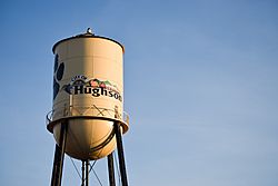
 "Welcome to Hughson" utility tank |
||
|
||
| Motto(s):
A Small Community, with a Big Heart!
|
||

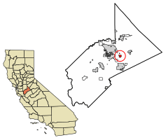
Location of Hughson in Stanislaus County, California
|
||
| Country | United States | |
| State | California | |
| County | Stanislaus | |
| Incorporated | December 9, 1972 | |
| Area | ||
| • Total | 1.91 sq mi (4.94 km2) | |
| • Land | 1.91 sq mi (4.94 km2) | |
| • Water | 0.00 sq mi (0.00 km2) 0% | |
| Elevation | 125 ft (38 m) | |
| Population
(2020)
|
||
| • Total | 7,481 | |
| • Density | 3,917/sq mi (1,514/km2) | |
| Time zone | UTC-8 (Pacific (PST)) | |
| • Summer (DST) | UTC-7 (PDT) | |
| ZIP code |
95326
|
|
| Area code | 209 | |
| FIPS code | 06-34904 | |
| GNIS feature ID | 1656082 | |
Hughson is a city in Stanislaus County, California, United States. It's part of the larger Modesto area. In 2020, about 7,481 people lived there, which was more than the 6,640 people in 2010.
Contents
Hughson's History
Hughson's story began in 1882 when Hiram Hughson bought a lot of land here. He owned about 5,000 acres! Because he owned so much land, the San Joaquin Railroad named their local train stop "Hughson" in the early 1900s.
In 1907, Hiram Hughson and another landowner, John Tully, started selling their land for people to settle. As more people moved in, the area became known as Hughson Township. On December 9, 1972, Hughson officially became a city.
Farming in Hughson
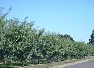
Hughson is surrounded by many farms and has always been a farming community. It was once famous for growing huge amounts of peaches. People even called it "The Peach Capital of the World"!
Today, peaches are not the main crop. Now, most of the farms grow almonds. Hughson is one of the biggest almond producers in the world. Other crops grown here include walnuts, nectarines, cherries, and apples. You might also see a few vineyards.
In recent years, some orchards have been taken down to make way for new buildings and developments.
Where is Hughson?
Hughson is located at 37°36′11″N 120°52′1″W / 37.60306°N 120.86694°W.
The United States Census Bureau says the city covers about 1.8 square miles (4.7 square kilometers) of land. There is no water within the city limits.
Hughson's Population
| Historical population | |||
|---|---|---|---|
| Census | Pop. | %± | |
| 1960 | 1,898 | — | |
| 1970 | 2,144 | 13.0% | |
| 1980 | 2,943 | 37.3% | |
| 1990 | 3,259 | 10.7% | |
| 2000 | 3,980 | 22.1% | |
| 2010 | 6,640 | 66.8% | |
| 2020 | 7,481 | 12.7% | |
| U.S. Decennial Census | |||
As of July 1, 2023, the United States Census Bureau estimated that about 7,683 people lived in Hughson.
Hughson in 2020
In 2020, Hughson had a population of 7,481 people. The city had about 3,925 people per square mile (1,514 people per square kilometer).
Most people identified as White (57.1%). About 45% of the population identified as Hispanic or Latino. There were also people who identified as African American, Native American, Asian, Pacific Islander, or from two or more races.
Hughson in 2010
In 2010, Hughson had 6,640 people. The population density was about 3,658 people per square mile (1,412 people per square kilometer).
Most residents (77.2%) identified as White. About 43.2% of the population identified as Hispanic or Latino. Other groups included African American, Native American, Asian, Pacific Islander, and people from two or more races.
The average household in Hughson had about 3.20 people. The average family had about 3.64 people. Many households (48%) had children under 18 living there.
The median age in Hughson was 32.8 years old. This means half the people were younger than 32.8 and half were older.
Schools in Hughson
Students in Hughson attend Hughson High School and Emilie J. Ross Middle School. These schools also serve students from nearby communities.
The Hughson Huskies football team has a proud history. They won the 1997 State Championships, as ranked by Cal-Hi Sports. They also won the CIF San Joaquin Division 3 Title in 1991, 1992, 1997, and 2000. The Huskies were also Trans Valley League Champions many times, including from 1994 to 1998.
Hughson in the News
The Hughson Chronicle is a local newspaper that covers news in Hughson and the surrounding farming areas. It has a circulation of about 4,200 copies.
Another newspaper, Valley Entertainment Monthly, was published in the 1990s. It focused on entertainment in the region and had its mailing address in Hughson. You could find it in many local shops and restaurants.
See also
 In Spanish: Hughson para niños
 | Delilah Pierce |
 | Gordon Parks |
 | Augusta Savage |
 | Charles Ethan Porter |


