Huntington (CDP), Massachusetts facts for kids
Quick facts for kids
Huntington, Massachusetts
|
|
|---|---|

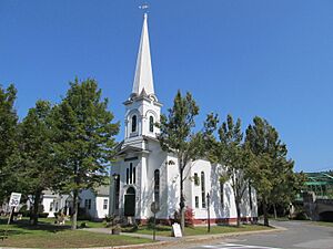
Stanton Hall
|
|

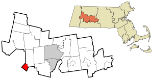
Location in Hampshire County in Massachusetts
|
|
| Country | United States |
| State | Massachusetts |
| County | Hampshire |
| Town | Huntington |
| Area | |
| • Total | 4.74 sq mi (12.28 km2) |
| • Land | 4.63 sq mi (11.99 km2) |
| • Water | 0.11 sq mi (0.29 km2) |
| Elevation | 377 ft (115 m) |
| Population
(2020)
|
|
| • Total | 857 |
| • Density | 185.14/sq mi (71.48/km2) |
| Time zone | UTC-5 (Eastern (EST)) |
| • Summer (DST) | UTC-4 (EDT) |
| ZIP code |
01050
|
| Area code(s) | 413 |
| FIPS code | 25-31750 |
| GNIS feature ID | 0608324 |
Huntington is a special area in Hampshire County, Massachusetts, United States. It's called a census-designated place (CDP). This means it's a place the government counts for population, but it's not a separate town. Huntington is the main village within the larger town of Huntington. In 2020, about 857 people lived in this CDP. It is part of the larger Springfield area.
Contents
Huntington's Location and Rivers
The Huntington CDP is found in the southwest part of the town of Huntington. It shares borders with other towns like Chester and Blandford. It also touches Russell and Montgomery.
Rivers and Roads in Huntington
The village of Huntington is right where the Westfield River meets its West Branch. A main road, U.S. Route 20, goes through the village. This road can take you about 11 miles (18 km) southeast to Westfield. If you go northwest on Route 20, you'll reach Chester in about 7 miles (11 km).
Another important road is Massachusetts Route 112. It goes north from Huntington along the Westfield River valley. You can travel about 22 miles (35 km) on this road to get to Cummington.
Norwich Bridge Village
In the northern part of the Huntington CDP, you'll find a small village called Norwich Bridge. This is where Route 112 crosses over the Westfield River.
Land and Water Area
The Huntington CDP covers a total area of about 4.7 square miles (12.2 square kilometers). Most of this area, about 4.6 square miles (12.0 square kilometers), is land. The rest, about 0.1 square miles (0.2 square kilometers), is water. This means about 2.22% of the area is covered by water.
Population of Huntington
| Historical population | |||
|---|---|---|---|
| Census | Pop. | %± | |
| 2020 | 857 | — | |
| U.S. Decennial Census | |||
The population of Huntington has changed over the years. In 2010, there were 936 people living in the CDP. By 2020, the population was 857 people. This information comes from the official U.S. Decennial Census.
See also
 In Spanish: Huntington (condado de Hampshire) para niños
 | Misty Copeland |
 | Raven Wilkinson |
 | Debra Austin |
 | Aesha Ash |

