Huntsville, Tennessee facts for kids
Quick facts for kids
Huntsville, Tennessee
|
|
|---|---|

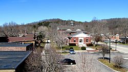
The courthouse square in Huntsville
|
|

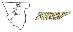
Location of Huntsville in Scott County, Tennessee.
|
|
| Country | United States |
| State | Tennessee |
| County | Scott |
| Founded | 1850 |
| Incorporated | 1965 |
| Area | |
| • Total | 8.30 sq mi (21.49 km2) |
| • Land | 8.30 sq mi (21.49 km2) |
| • Water | 0.00 sq mi (0.00 km2) |
| Elevation | 1,319 ft (402 m) |
| Population
(2020)
|
|
| • Total | 1,270 |
| • Density | 153.03/sq mi (59.09/km2) |
| Time zone | UTC-5 (Eastern (EST)) |
| • Summer (DST) | UTC-4 (EDT) |
| ZIP code |
37756
|
| Area code(s) | 423 |
| FIPS code | 47-36640 |
| GNIS feature ID | 1288766 |
Huntsville is a small town in Scott County, Tennessee, United States. It is the main town where the county government is located, also known as the county seat. In 2020, about 1,270 people lived there.
Contents
History of Huntsville
Huntsville was named after an early explorer, a "long hunter," whose last name was Hunt. A long hunter was someone who spent a lot of time hunting and exploring in the wilderness. This hunter camped under a rock shelter in the mid-1700s. Later, he brought his family to live in the area.
When Scott County was officially created in 1849, Huntsville was chosen as the county seat. This was because it was in the middle of the new county. It also had a great natural spring, which was important for water.
Huntsville During the Civil War
During the U.S. Civil War, Scott County strongly supported the Union. In June 1861, Tennessee held a vote on whether to leave the Union. Scott County voted 541 to 19 against leaving. This was the highest percentage against leaving in all of Tennessee.
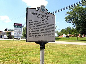
Even with strong opposition from Scott and other East Tennessee counties, Tennessee decided to leave the Union. Later that year, Scott County voted to leave Tennessee. They formed what they called the Independent State of Scott.
Historic Buildings in Huntsville
In 1906, a new courthouse square was built in Huntsville. The buildings were made with a light brown native sandstone. The courthouse itself burned down in 1946. However, two of these original sandstone buildings are still standing. These are the First National Bank building and the Old Scott County Jail. Both of these buildings are now listed on the National Register of Historic Places. This means they are important historical sites.
The Baker Family's Impact
The Baker family arrived in Huntsville shortly after the Civil War. They have been very involved in state and national politics for many years. James F. Baker (1864–1934) was a successful lawyer and newspaper owner.
His son, Howard H. Baker, Sr. (1902–1964), ran for governor of Tennessee in 1938. He later served in the U.S. House of Representatives. Howard H. Baker, Jr. (1925-2014), son of Howard Sr., was elected to the U.S. Senate in 1966. He became well-known as Vice Chairman of the Senate Watergate Committee in 1973. Baker later became the Senate Majority Leader (1981–1985). He also served as White House Chief of Staff (1987–1988).
Geography and Location
Huntsville is located at 36°24′39″N 84°29′42″W / 36.41083°N 84.49500°W. The town sits on top of the Cumberland Plateau. This is a large, flat area of land that is higher than the surrounding land. It is about 10 miles (16 km) west of where the plateau drops off.
Huntsville's southern edge is along cliffs that look over the New River. This river is about 15 miles (24 km) upstream from where it joins the Big South Fork of the Cumberland River. Huntsville is surrounded by low mountains and hills. These are part of the southern Cumberland Mountains.
Roads and Transportation
The center of Huntsville is located along State Route 63. This road is also called Howard Baker Highway. The town's boundaries stretch west to where State Route 63 meets U.S. Route 27. U.S. Route 27 is also known as Scott Highway. State Route 63 connects to Interstate 75 about 15 miles (24 km) east of Huntsville.
The United States Census Bureau says that Huntsville has a total area of 3.3 square miles (8.5 square kilometers). All of this area is land.
Population and Demographics
| Historical population | |||
|---|---|---|---|
| Census | Pop. | %± | |
| 1870 | 85 | — | |
| 1880 | 116 | 36.5% | |
| 1890 | 149 | 28.4% | |
| 1970 | 337 | — | |
| 1980 | 519 | 54.0% | |
| 1990 | 660 | 27.2% | |
| 2000 | 981 | 48.6% | |
| 2010 | 1,248 | 27.2% | |
| 2020 | 1,270 | 1.8% | |
| Sources: | |||
Huntsville's Population in 2020
| Race | Num. | Perc. |
|---|---|---|
| White | 1,238 | 97.48% |
| Black or African American | 4 | 0.31% |
| Native American | 3 | 0.24% |
| Asian | 5 | 0.39% |
| Other/Mixed | 15 | 1.18% |
| Hispanic or Latino | 5 | 0.39% |
As of the 2020 United States Census, there were 1,270 people living in Huntsville. There were 537 households and 249 families in the town.
Media
- The Independent Herald
- Hive 105, WBNT-FM
Notable People from Huntsville
- Howard Baker Jr. - He was a U.S. senator from Tennessee. He served as both the Senate Majority and Minority Leader. He was the first Republican elected to the U.S. Senate from Tennessee since the time of Reconstruction.
See also
 In Spanish: Huntsville (Tennessee) para niños


