
Hurricane Barry (2019) facts for kids
| Category 1 hurricane (SSHWS/NWS) | |

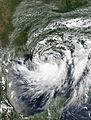
Hurricane Barry making landfall in Louisiana at peak intensity on July 13
|
|
| Formed | July 11, 2019 |
|---|---|
| Dissipated | July 19, 2019 |
| (Remnant low after July 15) | |
| Highest winds | 1-minute sustained: 75 mph (120 km/h) |
| Lowest pressure | 991 mbar (hPa); 29.26 inHg |
| Fatalities | 1 total |
| Damage | ≥ $600 million (2019 USD) |
| Areas affected | Midwestern United States, Southeastern United States, Gulf Coast of the United States, Arkansas, Oklahoma, Great Lakes region, Northeastern United States |
| Part of the 2019 Atlantic hurricane season | |

Hurricane Barry was a tropical storm that grew into a hurricane in July 2019. It was the first hurricane of the 2019 Atlantic hurricane season. Barry was also one of only a few storms to hit Louisiana as a hurricane in July.
The storm started as a swirling weather system over the central Midwestern United States. It moved south and entered the Gulf of Mexico on July 10. By July 11, it had become a tropical storm.
On July 13, Barry became a Category 1 hurricane. Its strongest winds reached about 75 mph (120 km/h). Later that day, Hurricane Barry made landfall in Louisiana. It hit near Marsh Island and Intracoastal City. After hitting land, Barry quickly weakened back into a tropical storm. By July 15, it was just a leftover low-pressure area over Arkansas. The storm fully disappeared by July 19.
Contents
How Hurricane Barry Formed and Moved

Hurricane Barry began as a low-pressure area over the central United States. This weather system moved south. It then became a large area of low pressure. Weather experts thought it might turn into a tropical cyclone.
On July 10, this system moved from Florida into the Gulf of Mexico. It brought many showers and thunderstorms. Forecasters believed it would soon become a tropical cyclone. The conditions in the Gulf were good for the storm to grow.
By the morning of July 13, the thunderstorms were closer to the storm's center. The storm was getting stronger. Experts believed Barry became a Category 1 hurricane around noon that day. This was based on information from special "Hurricane Hunter" planes. These planes fly into storms to measure their strength. Radar also showed winds of 75 mph (121 km/h).
Barry reached its strongest point with a central pressure of 991 millibars. At 18:00 UTC, Barry hit land as a Category 1 hurricane. It made landfall in Intracoastal City, Louisiana. After hitting land, it quickly lost strength. It became a tropical storm again. This made Barry the fourth storm to hit Louisiana as a hurricane in July.
By July 15, Barry had weakened into a low-pressure area. It then turned into a different type of storm. This storm brought heavy rain to parts of Canada, like Southern Ontario.
What Hurricane Barry Did
Hurricane Barry caused problems in several areas. Before Barry even formed, some beaches in Florida were closed. Sadly, one 67-year-old man died after ignoring warnings and swimming. The storm also brought strong winds and thunderstorms to the Gulf of Mexico.
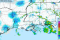
Barry dropped a lot of rain along its path. The most rain fell near Ragley, Louisiana, with 23.43 inches (595 mm). Small tornadoes, called waterspouts, were seen on Lake Pontchartrain. One tornado hit a neighborhood in New Orleans, damaging two homes.
The storm also caused high water levels. A tide station recorded a storm surge of almost 7 ft (2.1 m). This is when ocean water is pushed onto land. Some roads in Louisiana were closed because of flooding. For example, Louisiana Highway 1 was closed. This road is the only way to get to Grand Isle.
As Barry moved over Louisiana on July 13, many people lost electricity. Over 114,000 homes and businesses lost power. This happened because strong winds knocked down power lines. The areas with the most power outages were Lafourche Parish and Terrebonne Parish. All customers in Grand Isle lost power.
In Southern Ontario, Canada, the leftover storm caused problems. Many highways were blocked by water. Several cars were stuck in floodwaters. The storm even created a rare funnel cloud in Oro-Medonte.
In Arkansas, Barry brought a lot of rain, too. One area recorded 16.23 inches (412 mm) of rain. A police station was flooded, and a highway had to close. Rescue teams saved 20 people and over 70 animals from floodwaters. Luckily, no one died in Arkansas.
Overall, Hurricane Barry caused about $600 million in damages.
Related articles
Images for kids
-
Barry intensifying over the Gulf of Mexico on July 12
-
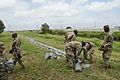
The Louisiana National Guard placing sandbags along a levee in Port Sulphur, Louisiana
-
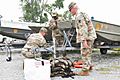
The Louisiana National Guard preparing for the coming of Hurricane Barry
-
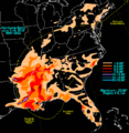
Total rainfall from Hurricane Barry and its remnants
-
Hurricane Barry intensifying, then making landfall in Louisiana
-

A Coast Guard helicopter rescue near Terrebonne Parish, Louisiana
-
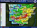
72-hour rainfall from Hurricane Barry in Arkansas
-
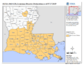
Parishes in Louisiana (beige) that received federal assistance from FEMA

.jpg)
.jpg)


.jpg)


