
Hurricane Erika (2003) facts for kids
| Category 1 hurricane (SSHWS/NWS) | |

|
|
| Formed | August 14, 2003 |
|---|---|
| Dissipated | August 17, 2003 |
| Highest winds | 1-minute sustained: 75 mph (120 km/h) |
| Lowest pressure | 986 mbar (hPa); 29.12 inHg |
| Fatalities | 2 direct |
| Damage | $10,000 (2003 USD) |
| Areas affected | Florida, Mexico, south Texas |
| Part of the 2003 Atlantic hurricane season | |
Hurricane Erika was an Atlantic hurricane that hit northeastern Mexico, close to the Texas border. It made landfall on August 16, during the 2003 Atlantic hurricane season. Erika was the eighth big storm, the fifth tropical storm, and the third hurricane of that year's season.
The storm started as a weak area of low pressure that was watched for five days. It grew stronger in the eastern Gulf of Mexico on August 14. Because of a high pressure system, Erika moved quickly westward. It became even stronger as conditions were just right for a storm to grow.
Contents
How Hurricane Erika Formed

A weak area of low pressure began to form on August 8. It slowly moved southwest. By August 9, it started to create rain and thunderstorms. This happened as it passed under a cold area of low pressure high up in the atmosphere.
As the system kept moving west, most of the thunderstorms stayed near the center of the upper low. This stopped a clear storm center from forming at first. On August 13, near the northwestern Bahamas, more thunderstorms appeared. This helped the upper low grow downwards, which then created an area of high pressure above it.
Erika Becomes a Tropical Storm
On August 14, a clear low-level storm center almost formed east of Key Largo, Florida. However, strong thunderstorms remained to the north, making it weaker. The middle part of the storm kept moving west and crossed over Florida.
After crossing Florida, special planes called Hurricane Hunters flew into the storm. They found a weak storm center but with winds strong enough to be a tropical storm. So, late on August 14, the system was officially named Tropical Storm Erika. At this time, it was about 85 miles (135 km) west of Fort Myers.
Erika Reaches Hurricane Strength

Erika continued to get stronger. It had good airflow and low wind shear, which means winds were not blowing in different directions and tearing the storm apart. This helped the storm's center become clearer. A high pressure system over the south-central United States pushed Erika to move west at about 25 mph (40 km/h).
On August 15, the thunderstorms began to form into organized bands. As its winds reached hurricane strength, an eye developed in the middle of the storm. This is a clear, calm center often seen in strong hurricanes.
Erika Weakens and Dissipates
After hitting land, Erika quickly weakened over the Sierra Madre Oriental mountains in Mexico. The storm died down early on August 17. After moving into the Gulf of California on August 18, it caused a new tropical disturbance to form. This disturbance moved northwest and finally weakened on August 20.
|
Tropical cyclones of the 2003 Atlantic hurricane season |
|||||||||||||||||||||||||||||||||||||
|
|
||||||||||||||||||||||||||||||||||||
|
|
|||||||||||||||||||||||||||||||||||||
Images for kids
-
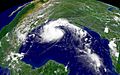
Tropical Storm Erika approaching Mexico on August 15
-
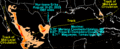
Rainfall data for Erika

See also
 In Spanish: Huracán Erika (2003) para niños
