
Hurstbourne, Kentucky facts for kids
Quick facts for kids
Hurstbourne, Kentucky
|
|
|---|---|

Hurstbourne entrance at US 60 and Lyndon Lane
|
|

Location of Hurstbourne in Jefferson County, Kentucky
|
|

Hurstbourne, Kentucky
Location in Kentucky

Hurstbourne, Kentucky
Location in the United States
|
|
| Country | United States |
| State | Kentucky |
| County | Jefferson |
| Incorporated | 1982 |
| Named for | a local farm |
| Area | |
| • Total | 1.81 sq mi (4.69 km2) |
| • Land | 1.80 sq mi (4.66 km2) |
| • Water | 0.01 sq mi (0.03 km2) |
| Elevation | 630 ft (190 m) |
| Population
(2020)
|
|
| • Total | 4,683 |
| • Density | 2,601.67/sq mi (1,004.23/km2) |
| Time zone | UTC-5 (Eastern (EST)) |
| • Summer (DST) | UTC-4 (EDT) |
| ZIP Code |
40222
|
| FIPS code | 21-38814 |
| GNIS feature ID | 2404748 |
Hurstbourne is a city in Jefferson County, Kentucky, United States. It's known as a "home rule-class city," which means it has the power to govern itself on local matters. In 2020, about 4,683 people lived there. Hurstbourne is also part of the larger Louisville Metro Government area.
Contents
History of Hurstbourne
Hurstbourne has a long and interesting history, starting even before Kentucky became a state.
Early Settlements and Land Grants
The land where Hurstbourne now stands was first given to Henry Harrison as a military grant. This means he received the land for his service. In 1774, John Floyd surveyed the area. Later, in 1779, Major William Linn built a place called Linn's Station. This station was a fortified settlement, like a small fort, along Beargrass Creek. It was an important stop on the road from the Falls of the Ohio to Fort Harrod.
The Long Run Massacre Connection
In 1781, a group of people were traveling to Linn's Station from Squire Boone's Station. Sadly, they were attacked by Native Americans and British soldiers in an event known as the Long Run Massacre. After some time, Major Linn's family left the area in the 1790s because there were questions about who truly owned the land.
Soldier's Retreat Estate
In 1789, Colonel Richard Anderson bought about 500 acres (2.0 km²) of land in the area. He built his own large estate and called it "Soldier's Retreat." His house faced some challenges, including damage from an earthquake in 1811 and being struck by lightning. It was eventually taken down in the 1840s.
Lyndon Hall and Hurstbourne Country Club
By 1842, John Jeremiah Jacob owned the property. He built a new house called Lyndon Hall. Today, this building is part of the clubhouse for the Hurstbourne Country Club.
Becoming the City of Hurstbourne
In 1915, the Hert family bought the property and gave it the name "Hurstbourne." A road called Hurstbourne Parkway was made wider in 1935. By 1965, the land was known as "Highbaugh Farms." As the nearby city of Louisville grew, people started building homes and businesses on this land.
Why Hurstbourne Became a City
Hurstbourne officially became a city in 1982. This was done to stop Louisville from taking over the area. By 1990, almost all the land within Hurstbourne's city limits had been developed with buildings and homes.
Rebuilding Soldier's Retreat
During the 1970s, as new buildings were going up, the old ruins of Colonel Anderson's "Soldier's Retreat" house were found. A local builder named Leroy Highbaugh Jr. excavated the ruins and rebuilt the house. In 1983, he and his family moved into the rebuilt Soldier's Retreat. Today, it stands as an important historical landmark in the area.
Geography and Location
Hurstbourne is located in the eastern-central part of Jefferson County. It covers a total area of about 1.8 square miles (4.7 square kilometers). Only a very small part of this area is water.
Where is Hurstbourne Located?
Hurstbourne has clear boundaries:
- To the north, it's bordered by Shelbyville Road (U.S. Route 60).
- To the east, you'll find Hurstbourne Parkway.
- To the south, it's next to I-64, a major highway.
- To the west, it's bordered by Oxmoor Farm and Oxmoor Center.
Neighboring Communities and Business Hubs
Hurstbourne is surrounded by other cities. To the north are Lyndon and Bellemeade. To the east is Jeffersontown. The area around I-64 and Hurstbourne Parkway is a busy place. It's like a mini-city, sometimes called an "edge city," with many office buildings, shopping centers, and industrial parks. This area was mostly empty land just 40 years ago!
Population and People
Hurstbourne has seen its population grow over the years.
How Many People Live in Hurstbourne?
| Historical population | |||
|---|---|---|---|
| Census | Pop. | %± | |
| 1990 | 4,420 | — | |
| 2000 | 3,884 | −12.1% | |
| 2010 | 4,216 | 8.5% | |
| 2020 | 4,683 | 11.1% | |
| U.S. Decennial Census | |||
In 2000, there were 3,884 people living in Hurstbourne. By 2010, this number grew to 4,216. The most recent count in 2020 showed the population had increased to 4,683 people.
Who Lives in Hurstbourne?
In 2000, there were 1,699 households in the city. A household is a group of people living together in one home. Most households were married couples living together. About 22% of households had children under 18.
The average age of people living in Hurstbourne in 2000 was 51 years old. This means many adults and older people live there.
Income and Economy
In 2000, the average income for a household in Hurstbourne was about $88,972 per year. For families, the average income was even higher, around $106,450. This shows that Hurstbourne is a well-off community. A very small percentage of families and people lived below the poverty line.
Images for kids
-
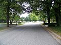
Summer day in Hurstbourne
-
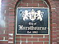
Hurstbourne entrance marker
-
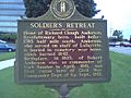
Historical marker


See also
 In Spanish: Hurstbourne (Kentucky) para niños
