
Ilo, Peru facts for kids
Quick facts for kids
Ilo
|
|||
|---|---|---|---|
|
City
|
|||
      |
|||
|
|||

Ilo, Peru
Location in Peru
|
|||
| Country | |||
| Region | Moquegua | ||
| Province | Ilo | ||
| District | Ilo | ||
| Area | |||
| • Total | 295.6 km2 (114.1 sq mi) | ||
| Elevation | 15 m (49 ft) | ||
| Population
(2017)
|
|||
| • Total | 66,118 | ||
| • Estimate
(2015)
|
67,428 | ||
| • Density | 223.67/km2 (579.31/sq mi) | ||
| Demonym(s) | Ileños | ||


Ilo is a busy port city located in southern Peru. It is home to about 66,000 people. Ilo is the second largest city in the Moquegua Region and serves as the capital of the Ilo Province. It's a place with a rich history and important connections to the Pacific Ocean.
Contents
Discovering Ilo's Past
Ilo has a long and interesting history. Before the Spanish arrived in the 1500s, the area was home to the Chiribaya culture. These ancient people lived here long before any European explorers.
Early Settlements and Agriculture
When the Spanish came, they received land from King Charles V. They brought olive trees to the region. Growing olives became the main way people made a living until the early 1900s.
A small town called Pacocha was built right by the ocean, where the Osmore River flows into the Pacific. However, big tides in the late 1800s flooded Pacocha. Because of this, everyone moved to where Ilo is today, and the city got its current name. For a long time, most people lived along the Osmore River, which only flows sometimes during the summer.
Ilo's Role in Trade
Ilo was once a popular stop for ships traveling from the east coast to the west coast of the United States. These ships would sail all the way around Tierra del Fuego at the southern tip of South America.
In the 1800s, a pier was built in Ilo. This helped international trade grow a lot in the region. People from Italy, China, Japan, and Germany came to live in Ilo during this time.
However, things changed when the Transcontinental Rail Road was built in the U.S. and the Panama Canal opened. These new routes made sea travel faster and easier, so fewer ships stopped in Ilo. After that, mostly steamships carrying goods between Peruvian and Chilean ports used Ilo. An important naval event, the Battle of Pacocha, also happened near Ilo.
Modern Industries and Growth
Along with the pier, a railroad was built to connect Ilo to Moquegua. This railroad was nicknamed Calamazo, which came from the name "Kalamazoo" stamped on the equipment used to build it.
Today, the main ways people earn money in Ilo are through fishing and mining. Large copper mines, originally owned by the Southern Peru Copper Corporation (SPCC), have created many jobs. SPCC was started in the mid-1900s. Many people who work for SPCC, both Americans and Peruvians, live in a part of Ilo called Ciudad Nueva.
There is also a copper processing plant and a refinery located about 10 kilometers from the city. These industries have sometimes led to concerns about air and water quality in the area. Ilo's industrial activities were even shown in a Canadian documentary film called The Corporation, which talked about environmental issues caused by industries.
Ilo also has nice places for swimming, like Pozo de Lisas, Monte Carlo, and Puerto Ingles. In the past, Bolivia has used Ilo as a special port to access the ocean for both fun and trade.
How to Get Around Ilo
Ilo is an important place for transportation, especially for its port.
In 1992, the Peruvian government made a special agreement with Bolivia. Bolivia is a country that doesn't have a coastline. Peru gave Bolivia a 99-year lease to use a port facility in Ilo. This means Bolivia can use Ilo to access the Pacific Ocean, almost like having its own coastline! Bolivia lost its land on the Pacific coast after a war with Chile in the 1800s. There are also plans for a new railway that would connect Ilo through Bolivia all the way to Brazil.
Ilo's Weather and Climate
Ilo has a very pleasant climate. Temperatures usually stay between 18 and 28 degrees Celsius (about 64 to 82 degrees Fahrenheit) all year round. It almost never rains in Ilo. This is because the city is located just north of the Atacama Desert, which is one of the driest coastal deserts in the world!
| Climate data for Ilo (Punta Coles), elevation 25 m (82 ft), (1991–2020) | |||||||||||||
|---|---|---|---|---|---|---|---|---|---|---|---|---|---|
| Month | Jan | Feb | Mar | Apr | May | Jun | Jul | Aug | Sep | Oct | Nov | Dec | Year |
| Mean daily maximum °C (°F) | 25.5 (77.9) |
25.7 (78.3) |
24.9 (76.8) |
23.3 (73.9) |
21.8 (71.2) |
19.9 (67.8) |
18.8 (65.8) |
18.7 (65.7) |
19.3 (66.7) |
20.9 (69.6) |
22.9 (73.2) |
24.3 (75.7) |
22.2 (71.9) |
| Mean daily minimum °C (°F) | 19.2 (66.6) |
19.3 (66.7) |
18.7 (65.7) |
17.4 (63.3) |
16.5 (61.7) |
15.6 (60.1) |
14.9 (58.8) |
14.5 (58.1) |
14.7 (58.5) |
15.9 (60.6) |
17.2 (63.0) |
18.0 (64.4) |
16.8 (62.3) |
| Average precipitation mm (inches) | 0.4 (0.02) |
0.4 (0.02) |
0.5 (0.02) |
0.0 (0.0) |
0.6 (0.02) |
0.4 (0.02) |
3.0 (0.12) |
1.6 (0.06) |
1.8 (0.07) |
0.6 (0.02) |
0.7 (0.03) |
0.0 (0.0) |
10 (0.4) |
| Source: National Meteorology and Hydrology Service of Peru | |||||||||||||
Ilo and the Interoceanic Highway
Ilo is one of three important ports in Peru that are part of the Interoceanic Highway. This highway is a big road project that connects the state of Acre in the Amazon Basin of Brazil all the way across the Andes mountains to the Pacific Ocean. This makes Ilo a key link for trade between South America's Atlantic and Pacific coasts.
Fun Places to See in Ilo
Ilo has many interesting places to visit, especially in its main downtown area.
- St. Jerome's Temple: This beautiful church was built in 1871.
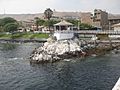
- Glorieta José Gálvez: A lovely gazebo or bandstand built in 1915.
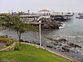
- State Pier: This pier was built in the late 1800s and is still an important part of the port.
- Punta Coles: A scenic point that offers great views.
- Peruvian Navy Museum: Here you can learn about Peru's naval history.
- "El Algarrobal" Museum: This museum likely showcases local history and culture.
- The powerful tubing right hander wave: For those who love surfing, there's a famous wave in the bay!
BoliviaMar: Bolivia's Access to the Sea
About 17.5 kilometers south of Ilo, there's a small strip of beach called BoliviaMar. This area is a special port concession given to Bolivia. It's also planned to be the end point for a future railway project, giving Bolivia another way to reach the Pacific Ocean.
Images for kids
-
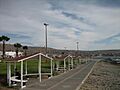
The Malecon in Ilo.
-
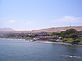
A view of Ilo.
-
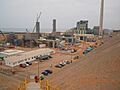
An industrial view near Ilo.
-
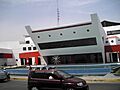
The Municipality building in Ilo.
-
Another view of Ilo.
-
The Glorieta on the Malecon.
-

The flag of Ilo.
-
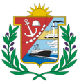
The coat of arms of Ilo Province.
See also
 In Spanish: Ilo para niños
