
Osmore River facts for kids
Quick facts for kids Osmore River |
|
|---|---|

Moquegua (Osmore) River Valley
|
|

Location of mouth
|
|
| Other name(s) | Moquegua River, Rio Coscori, Rio Tumilaca, Ilo River |
| Country | Peru |
| State | Moquegua Region |
| Region | South America |
| Physical characteristics | |
| Main source | Chuquiananta and Arundane Mountains Sierra, Peru 5,100 m (16,700 ft) 16°52′00″S 70°26′00″W / 16.86667°S 70.43333°W |
| River mouth | Pacific Ocean Ilo, Coastal Pacific Ocean, Peru 0 m (0 ft)Pacific Ocean 17°43′0″S 71°20′0″W / 17.71667°S 71.33333°W |
| Length | 480 km (300 mi)approx. |
| Basin features | |
| River system | Moquegua River |
| Basin size | 3,480 km2 (1,340 sq mi)approx. |
The Osmore River is a river system in southern coastal Peru. It is also known by other names like Moquegua, Ilo, or Tumilaca. The river flows from the northeast to the southwest through the Moquegua Region.
The Osmore River starts high up in the snowy peaks of the Chuqi Ananta and Arundane mountains. Its source is about 5,100 meters (16,700 feet) above sea level. As it flows down from the Andes mountains, the river changes its name. It starts as the Moquegua, then becomes the Osmore in the middle valley. Further down, it is called the Rio Ilo. Sometimes, parts of the river even disappear into underground channels!
Archaeologists have found many ancient sites along the Osmore River valley. More than 500 sites show that people have lived here for over 10,000 years. One important site is Asana, which was used by humans for 8,000 years. This area was also where the Wari culture and Tiwanaku culture met and interacted.
Contents
Exploring the Osmore River's Path
The Osmore River basin is located in the Moquegua Region of Peru. It stretches across the Mariscal Nieto and Ilo provinces. The river system is part of the Pacific slope, meaning its waters eventually flow into the Pacific Ocean.
The river follows a natural crack in the Earth called the Cholo fault. It flows for about 480 kilometers (300 miles). The river basin covers an area of about 3,480 square kilometers (1,343 square miles). A large part of this area, about 680 square kilometers (260 square miles), is a "wet basin" located high up in the mountains.
The Osmore River drops over 5,000 meters (16,400 feet) from its source to the Pacific Ocean. This makes it a very steep river! It has many smaller rivers, called tributaries, that join it along its journey. These tributaries start in the western cordillera (mountain range).

River Boundaries and Tributaries
To the north, the Osmore River basin borders the Tambo River basin. To the east and south, it borders the Locumba River basin. To the west, it meets the Pacific Ocean.
The main tributaries of the Osmore River include:
- The Huraicane River (also called Otora): This river drains an area of 505 square kilometers (195 square miles) and flows for 59 kilometers (37 miles).
- The Torata River (Quilancha River): It drains 410 square kilometers (158 square miles) and flows for 65 kilometers (40 miles).
- The Moquegua (Tumilaca): This is the largest tributary, covering 625 square kilometers (241 square miles). It has two smaller branches: the Coscori (formed by the Asana River and the Chareque) and the Capallune.
The upper part of the Osmore River is known as the Otora Valley.
River Sections and Towns
The middle part of the river became famous as the Moquegua valley during colonial times. The city of Moquegua was built here. In the lower part of the middle valley, the river mysteriously disappears underground. It then reappears about 30 kilometers (19 miles) before reaching the coast. Here, it becomes a wide valley and flows through the town of Ilo.
Near the coast, another stream joins the river. This stream brings water from the dry desert area called the Quebrada Seca de Guaneros. Many springs in the lower valley were used for farming. The river in this coastal section is known by its ancient name, Rio Ilo (Ilo River). Fishing villages are found along this coastline.

The upper Osmore has several valleys. The middle section has farms, the city of Moquegua, and ancient sites like Omo and Yaral. This is where the river goes underground, leaving a deep gorge.
The river's floodplains are narrow at first, about 115 meters (377 feet) wide. Closer to the sea, they widen to about 300 meters (980 feet). In 1981, archaeologists confirmed that the Tiwanaku state existed in the Moquegua Region. They found 17 Tiwanaku sites in the Osmore river area.
The small town of Pacocha was built at the river's mouth. But in the late 1800s, high tides flooded the town. So, the people moved to Ilo, which is on higher ground.
Life and Environment in the Valley
The environment in the Osmore Valley changes with elevation. Above 2,000 meters (6,500 feet), the amount of rainfall changes with the seasons. However, at lower elevations, there is almost no rain. This area is considered one of the driest deserts in the world. Decades can pass without any rain at all!
Highland Ecosystems
In the upper parts of the valley, the Asana River is a major tributary of the Moquegua (Tumilaca) River, which later becomes the Osmore. The Asana River starts at about 4,800 meters (15,700 feet) high in the south-central Andes mountains. This area is part of the high puna, which is above 3,800 meters (12,500 feet) in elevation.
The river's water comes from seasonal rain and melting snow from the Andes. In these high areas, not many people lived. Instead, people herded animals like llamas and alpacas. They also grew potatoes, which can survive cold weather.
Below 3,000 meters (9,800 feet), many streams that feed the Asana River are usually dry. But above this elevation, streams flow all year round from rain and snowmelt. During the rainy season, the water flow is much higher than in the dry season.
The entire Asana River valley is delicate and can have landslides. The river flows through two main environmental zones. One is the puna region, above 3,800 meters (12,500 feet). Here, the climate is colder, and there is more rain. Plants and animals found here are similar to those in other high mountain areas. The valleys in this region are narrow.
Economy and Resources

The Osmore Valley has rich, fertile land. Farmers grow crops like grapes, corn (maize), pepper (aji), and cotton. Grapes from the valley are used to make a famous type of brandy called Pisco.
The coastal area around Ilo has been important for its economy since the 1500s. People here have developed farming (especially olive groves) and fishing. Even though water is scarce, some olive groves are still farmed today.
A very important economic activity in the region is the large porphyry copper mine called the Toquepala mine. This is an open-pit mine that produces copper, molybdenum, and other metals like rhenium, silver, gold, and zinc.
Uncovering Ancient History
Archaeologists have studied many sites along the Osmore River, from the high mountains to the lower valley. These studies help us understand the people who lived here long ago.
Toquepala Caves: Ancient Art
One important ancient cave found in the Osmore Basin is the Toquepala Caves. These caves are about 2,800 meters (9,200 feet) above sea level. They became famous when copper was discovered in the valley. A mining company helped fund studies of the cave paintings in 1963.
The caves contain amazing rock art made by hunter-gatherers who lived here about 10,000 years ago. The art shows hunting scenes with armed men hunting guanaco animals. The paintings use seven different colors. This art was at its best when the Collawa people lived here during the Stone Age.
Many other archaeological studies have been done in the river basin. The Contisuyu Program was created to help with these efforts. It is a joint project involving several museums and institutions, supported by the mining company. Their goal is to study, protect, and share the cultural heritage of the Moquegua region.
Cerro Baul: A Mountain City

One of the oldest historical sites is Cerro Baul. This is a tall, flat-topped hill (mesa) in the middle of the Moquegua Valley. An ancient city once stood on top of this hill, but now it is in ruins.
Cerro Baul was a major center for the Wari culture between 600 AD and 1000 AD. This was a place where the Wari people met the Tiwanaku empire, which existed at the same time. Even though both cultures built strong settlements on hilltops, there is no sign that they fought each other.
Around 600 AD, the Wari brought many settlers to Cerro Baul. The Tiwanaku people mostly lived in the lower parts of the Moquegua river valley. Later, the two cultures worked together more.
Other sites near Cerro Baul include Cerro Mejia, which has many walls, and Cerro Trapiche, a Wari/Huaracane site with a walled hill and hidden slingstones.
After 1000 AD, both the Tiwanaku and Wari cultures left their settlements in Moquegua. By 1100 AD, both empires had completely fallen apart. The Chiribaya culture continued to live along the lower and middle parts of the Osmore River until about 1400 AD.
Archaeologists have found many similarities in the religious art of the Wari and Tiwanaku. This suggests that they had close contact. The Tiwanaku culture also influenced some Wari pottery.
The Inca Period at Cerro Baul
Later, the Inca arrived in the area. The local people hid on the rocky cliff of Cerro Baul because they could not fight the large Inca army. When the Inca emperor Mayta Capac attacked, he surrounded the hill. After 50 days, the people on Cerro Baul ran out of food and water. They surrendered after learning that Mayta Capac would not harm them.
Today, you can still see the ruins of ancient storehouses and other buildings on Cerro Baul. These structures were built by the original inhabitants, not the Incas. From the top of Cerro Baul, you can see the Cuajone open-pit copper mine, which is where the Moquegua River begins. The "citadel city of Cerro Baul" covers about 8 hectares (20 acres). It holds ancient buildings, many artifacts, woven textiles, and even mummified human remains. You can also see abandoned farm terraces on the mountain slopes, with canals leading to the desert plains.
Ancient Farm Terraces
On both sides of the river valley, you can see abandoned farm terraces built into the hillsides. These terraces have old canal systems. They are called andenes by the local people. Even today, people still farm on terraces on the hills, but much less land is used than in ancient times. The old, barren terraces still exist. One mystery is why these terraces were abandoned.
Torata: A Historic Town
Torata is another ancient settlement located in the Sierra mountains. Some local people moved here from Cerro Baul after the Incas forced them to. Torata has large terrace systems and impressive ancient buildings. It also has an altiplano (high plateau) with stone storehouses built by the Incas that were abandoned 500 years ago.
A fortified village can also be seen here, where Inca architecture and pottery mixed with the local culture. An Inca administrative center is next to this village. Torata was also the site of The battle of Torata on January 19, 1823. This battle was part of the Peruvian War of Independence.
Moquegua: A Modern City

Moquegua is now a modern city in the lower part of the river valley. In this valley, modern canal systems and irrigated farms are well-developed and productive. The area around Moquegua is dry, with less than 200 millimeters (8 inches) of rain each year.
Archaeological finds, called middens (ancient trash heaps), show what crops were grown in the past. Long ago, farmers grew maize (corn), beans, cotton, and avocado fruit trees. Today, these have mostly been replaced by grapes, which are used to make the popular Pisco brandy. Moquegua is the capital of the Moquegua Region and is located about 1,144 kilometers (711 miles) south of Peru's capital city, Lima.
Ilo: A Port City

Ilo is a city on the coast. You can still see some olive orchards here, which are a reminder of past civilizations. Before the Spanish arrived in the 1500s, the Chiribaya civilization lived in this area. Water is very scarce in Ilo.
A large copper smelter plant is located near the city. This plant gets its water from desalinated seawater, which means ocean water is treated to remove the salt. Fishing and collecting seafood have been traditional activities here for a long time. Ilo is now the largest port city in the Moquegua Region.
Images for kids
-
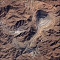
Stalleite picture of the Toquepala copper mine
See also
 In Spanish: Río Osmore para niños
