Inca-Caranqui facts for kids
| Location | Ecuador |
|---|---|
| Coordinates | 0°19′19″N 78°07′18″W / 0.32194°N 78.12167°W |
| Type | archaeological site |
| History | |
| Founded | early 1500s |
| Site notes | |
| Condition | remnants only |
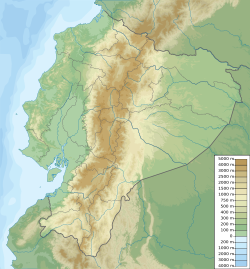
The Inca-Caranqui archaeological site is a cool ancient place. You can find it in the village of Caranqui. This village is just outside the city of Ibarra, Ecuador. It's in a green valley, high up at about 2,299 metres (7,543 ft) (7,543 feet) above sea level.
This area was once the very northern edge of the huge Inca Empire. It was the last part the Incas added before the Spanish arrived in 1533. People also call this ancient area the Pais Caranqui, which means 'Caranqui country'.
Contents
Life Before the Incas Arrived
Before the Incas came, the land north of Quito was home to many small groups. These groups were called chiefdoms. They lived about 160 kilometres (99 mi) (100 miles) north, close to what is now the border with Colombia.
Some of these groups were the Caranqui, Cayambe, Otavalo, and Cochasquí. You can still find towns and cities with these names today! The Caranqui name is used for all these groups together. They likely spoke similar languages and had similar ways of life.
Who Were the Caranqui People?
The Caranqui and other people in northern Ecuador are often called the Cara people. Their culture is known as the Cara culture. Some stories say they came from the semi-mythical Quitu culture. The city of Quito gets its name from this ancient group.
These chiefdoms lived in the Sierra region of Ecuador. This is a high mountain area between the Guayllabamba River and the Mira River. Experts believe about 100,000 to 150,000 people lived here before the Incas arrived.
Mysterious Earthen Mounds
A special thing about the Caranqui region are the many large man-made mounds of earth. Locals call them "tolas." These mounds were built between 1200 and 1500 CE. Most are found around the Imbabura Volcano. They are at elevations from 2,200 metres (7,200 ft) (7,218 feet) to 3,000 metres (9,800 ft) (9,843 feet).
The climate here is perfect for growing maize (corn). Corn was the main food for people back then, and it still is today! There were hundreds of these tolas, but many have been destroyed. Some are as big as 200 metres (660 ft) (656 feet) on each side and 10 metres (33 ft) (33 feet) to 15 metres (49 ft) (49 feet) tall. Archaeologists think they were used as platforms for important homes, ceremonies, and burials.
The Inca Takeover
A Spanish writer named Miguel Cabello de Balboa wrote about how the Incas conquered northern Ecuador. The Incas came from the high Andes mountains in southern Peru. They found Ecuador's lower mountain areas to be very rich and green.
Inca Emperors and Battles
The Inca Emperor Topa Inca Yupanqui (who ruled from about 1471 to 1493) started the conquest of Ecuador. He faced strong resistance from the local leaders. His son, Huayna Capac (who ruled from about 1493 to 1525), finished the job.
Huayna Capac worked from the Inca's northern capital, Tumebamba (which is now Cuenca). He built many pukaras (hilltop fortresses) at Pambamarca to fight the Cayambes. He also built more pukaras around Caranqui. Then, he moved in on the groups that were still fighting back.
The fighting lasted for more than ten years. Finally, the Incas won near the city of Ibarra.
The Lake of Blood
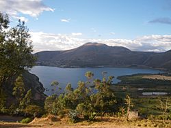
According to Cabello de Balboa, Huayna Capac ordered a terrible event. He had many Caranqui men killed because they had fought against him. This event happened on the shores of a lake. To this day, the lake is known as Yaguarcocha, which means "Blood Lake."
The Incas' final victory happened sometime between the 1490s and 1520. Spanish writers say that Huayna Capac's son, Atahualpa, who would later become emperor, was part of this battle. This suggests a later date for the victory. However, some say Atahualpa was born in Caranqui around 1500 CE. You can find a statue of Atahualpa and a museum about him in the town today.
Caranqui was the most northern area that became a full part of the Inca Empire. The Incas did build a fort at Rumichaca Bridge, about 75 kilometres (47 mi) (47 miles) further north. This is now on the border between Ecuador and Colombia. The Pasto people lived on both sides of this border, but the Incas only partly conquered them.
Changes in Language
Today, Caranqui is often spelled Karanki. The Caranqui people lost their original Caranqui language, which was probably a Barbacoan language. This happened in the 1600s or 1700s. Now, like other mountain people, they speak Kichwa (an Ecuadorian version of Quechua) and Spanish.
The Inca-Caranqui Site Today
After the Incas won, Caranqui became an important military town. The Inca army stayed there to keep control of the area.
What Spanish Explorers Saw
A Spanish writer named Pedro Cieza de León visited Caranqui in 1544. He wrote that it was the ruin of a big Inca center. It had a Temple of the Sun, a main plaza with a large water pool, and a place for Inca soldiers. It also had an acllawasi, which was a home for 200 aclla. These were special women chosen by the Incas.
We're not sure if most of the buildings were made by Huayna Capac in the early 1500s or by Atahualpa in the 1520s. Atahualpa might have used the site for his royal ceremony and wedding around 1525, after his father died.
What Remains Today
Most of the old Inca center has been destroyed as the town grew. But you can still see two standing walls with doors and niches in the middle of Caranqui village.
The most amazing part of the site is a semi-underground pool. It was found in 2008 on an empty lot bought by the town. This pool is made of beautifully cut stone. It was the religious and ceremonial heart of the Inca settlement. The pool is shaped like a rectangle, about 10 metres (33 ft) (33 feet) by 16 metres (52 ft) (52 feet) in size. Its walls are about one meter (3 feet) high. Canals, water spouts, and drains allowed the pool to be filled and emptied.
Other Inca sites built by Huayna Capac, like Quispiguanca in the Sacred Valley of Peru, also have water pools. But the pool at Caranqui is much bigger. This suggests that many people used it for important ceremonies.
Archaeologists have found other Inca buildings near the pool. They think a large Inca hall (called a kallanka) and a main plaza were next to the pool complex on its western side.
See also
 In Spanish: Inca-Caranqui para niños
 | Laphonza Butler |
 | Daisy Bates |
 | Elizabeth Piper Ensley |


