
Inca Trail to Machu Picchu facts for kids
The Inca Trail to Machu Picchu (also known as Camino Inca) is a famous hiking path in Peru. It leads to the ancient city of Machu Picchu. There are three main routes: the Mollepata, the Classic, and the One Day trail. The Mollepata route is the longest and goes over the highest mountain pass.
This amazing trail winds through the Andes mountains. You'll see different environments like misty cloud forests and high, cold alpine tundra. Along the way, you'll find old Inca settlements, tunnels, and many ruins. The journey ends at the Sun Gate on Machu Picchu mountain. Be aware that the longer routes go very high, over 4,200 meters (13,780 feet) above sea level. This can sometimes cause altitude sickness, which makes you feel dizzy or sick.
To protect the trail from too much use, the Peruvian government limits how many people can hike it each day. You must book your trip in advance. Only 500 people are allowed on the trail daily. Out of these, only 200 are hikers; the rest are guides and porters. Because of this, permits for busy times sell out very quickly.
The trail is closed every February for cleaning and maintenance. This helps keep it safe and beautiful for everyone.
Contents
The Classic Inca Trail

Most trekkers take four or five days to complete the "Classic Inca Trail." However, a shorter two-day trek is also an option, starting from a different point.
The Classic trail usually begins near the Urubamba River, about 82 or 88 kilometers (51 or 55 miles) from Cusco. The starting elevation is around 2,600 to 2,800 meters (8,530 to 9,186 feet).
Both starting points meet up above the Inca ruins of Patallacta (also called Llaqtapata). This was an important site for religious ceremonies and growing crops. It also housed soldiers from a nearby fort called Willkaraqay. The trail goes up and down, following the Cusichaca River.
At a small village called Wayllapampa (meaning "grassy plain"), the Classic trail connects with the Mollepata Trail. This village is about 3,000 meters (9,842 feet) high. Wayllapampa has about 400 people living there. Pack animals like horses, mules, and llamas are allowed up to this point.
From Wayllapampa, the trail turns west and starts climbing steeply. To protect the path, pack animals are not allowed past this point. Also, you can't use hiking poles with metal tips on the rest of the trail for the same reason.
Climbing Dead Woman's Pass


As you climb towards Warmiwañusqa, also known as "Dead Woman's Pass," you'll notice the scenery changing. The pass looks like a woman lying down. You'll walk through a cloud forest with special Polylepis trees. A campsite called Llulluch'apampa is located at 3,800 meters (12,467 feet) on this part of the trail.
The pass itself is the highest point on the Classic trail, at 4,215 meters (13,828 feet) above sea level. It's a challenging climb, but the views are amazing!
After crossing the pass, the trail drops sharply into the Pakaymayu valley. About 2.1 kilometers (1.3 miles) and 600 meters (1,968 feet) below the pass is the Pakaymayu campground.
Ancient Inca Sites

After Pakaymayu, the trail starts climbing steeply again on the other side of the valley. About one kilometer (0.6 miles) up, at 3,750 meters (12,303 feet), you'll find the Inca tampu Runkuraqay. These ruins offer great views of the valley. They were carefully restored in the late 1990s.
The trail continues to climb, passing a small lake called Quchapata. This area used to be a campsite and is known for deer. However, camping is no longer allowed here to protect the environment. The trail then reaches another pass at 3,950 meters (12,959 feet).
You'll continue through a high cloud forest. The path goes up and down, sometimes very steeply. You'll get more and more dramatic views of the mountains and deep valleys. Next, you'll reach Sayaqmarka ("steep-place town") and then the tampu Qunchamarka. You'll also pass a long Inca tunnel and a viewpoint overlooking two valleys: the Urubamba and Aobamba.
-
Sayacmarca
-
Conchamarka

.jpg)

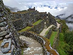
Another high point is crossed at 3,650 meters (11,975 feet), followed by a campground. After a short descent, you'll find a site with many ruins. This area is called Phuyupatamarka ("cloud-level town").
Hiram Bingham III first found this site, but much of it was covered in plants. Later, a team named Fejos uncovered the rest. The site's design fits perfectly with the natural landscape. It includes five fountains and an altar, which was likely used for llama sacrifices.
The trail then drops about 1,000 meters (3,280 feet). This includes a challenging staircase of about 1,500 steps, some carved right into the solid rock. The plants become much thicker and more like a jungle, with many butterflies and birds. You'll also go through a second Inca tunnel on this section.

Even before the tunnel, you'll start seeing the Willkanuta River again. These views become more frequent. After the tunnel, you can see the town of Machupicchu (Aguas Calientes) and hear trains running along the river. As you get closer to Intipata, you'll see views of the "Two Day" Inca Trail. A small path leads directly to Wiñay Wayna, while the main route continues to Intipata.
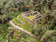
Intipata (also called Yunkapata) is a recently discovered area with many farming terraces. These terraces follow the curved shape of the land. Here, the Inca grew crops like potatoes, maize (corn), fruits, and sweet potatoes.

The name Wiñay Wayna (meaning "forever young") refers to both a hostel and campsite, and a set of Inca ruins. There are two main groups of buildings, an upper and a lower, built among many farming terraces on this mountainside. A long series of fountains or ritual baths, using as many as 19 natural springs, runs between the two groups of buildings.
From Wiñay Wayna, the trail goes up and down along the side of Machu Picchu mountain. After about 3 kilometers (1.8 miles), you'll reach the steep stairs leading to Inti Punku ("sun gate"). When you reach the top of this ridge, you'll see the incredible ruins of Machu Picchu spread out below you. A short downhill walk is the very last part of the trail.
Inca Trail Permits and Rules
Because the Inca Trail is so popular, the Peruvian Government has put rules in place. These rules help protect the trail and the ancient city of Machu Picchu. The most important rule is a quota system, started in 2001. This means only a certain number of people (hikers, porters, and guides) can hike the Inca Trail each day.
This system is still used today. If you want to hike the Inca Trail, you must get a permit beforehand. As of 2016, 500 permits are given out each day. All permits for the year are released in October and are sold very quickly, especially for the busy season. Most tour operators suggest buying permits as soon as they become available.
The government also requires every hiker on the trail to be with a guide. Because of this rule, you can only get permits through a tour operator that is registered with the government. All permits are linked to a specific passport and cannot be transferred to another person. The government watches the trail closely, with several checkpoints along the way.
Inca Trail Elevation Changes

The elevation on the Inca Trail changes a lot. People often have trouble with altitude sickness, especially if they haven't spent much time getting used to the high altitude in Cusco before starting the trek.
Cusco itself is at 3,200 meters (10,498 feet), which is already higher than Machu Picchu. However, many parts of the Inca Trail are much higher.
The trail starts at 2,600 meters (8,530 feet) and climbs to 3,300 meters (10,826 feet) on the first day. The second day involves climbing over Dead Woman's Pass, which is the highest point on the Inca Trail at 4,200 meters (13,780 feet). This is the most challenging point for altitude sickness. Luckily, you don't spend much time at this very high elevation, and the trail soon drops down to 3,600 meters (11,811 feet).
From this point, the trail only goes downhill until you arrive at Machu Picchu, which is at 2,430 meters (7,972 feet).
See also
 In Spanish: Camino Inca a Machu Picchu para niños
