Inglewood-Finn Hill, Washington facts for kids
Quick facts for kids
Inglewood-Finn Hill, Washington
|
|
|---|---|
|
Neighborhood
|
|

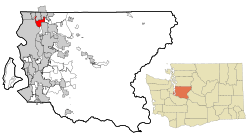
Location of Inglewood-Finn Hill, Washington
|
|
| Country | United States |
| State | Washington |
| County | King |
| Area | |
| • Total | 8.0 sq mi (20.6 km2) |
| • Land | 5.8 sq mi (15.0 km2) |
| • Water | 2.2 sq mi (5.7 km2) |
| Population
(2010)
|
|
| • Total | 22,707 |
| • Density | 3,922.6/sq mi (1,514.5/km2) |
| Time zone | UTC-8 (Pacific (PST)) |
| • Summer (DST) | UTC-7 (PDT) |
| FIPS code | 53-33380 |
Inglewood-Finn Hill was once a special area in King County, Washington, USA. It was called a "census-designated place" because the government counted its population separately. In 2010, about 22,707 people lived there. Most of this area became part of the nearby city of Kirkland in 2011. Inglewood-Finn Hill was known as one of the wealthier areas in Washington state. This was based on how much money people earned on average.
Contents
History of Inglewood-Finn Hill
The area known as Inglewood was first planned and named in 1888. It was named by an early settler called L.A. Wold. In 2011, most of Inglewood-Finn Hill officially joined the city of Kirkland. Because of this, the United States Census Bureau no longer listed it as a separate place. This change happened as part of their yearly survey of city borders.
Geography and Location
Inglewood-Finn Hill is located in Washington state, north of what used to be the city limits of Kirkland, Washington. It is also south of another city called Kenmore. In December 2009, the city council of Kirkland voted to include almost all of Inglewood-Finn Hill into Kirkland.
Area and Water Features
According to the United States Census Bureau, the total area of Inglewood-Finn Hill was about 8.0 square miles (20.6 square kilometers). Out of this, about 5.8 square miles (15.0 square kilometers) was land. The remaining 2.2 square miles (5.6 square kilometers) was water, which is about 27% of the total area.
Population and People
| Historical population | |||
|---|---|---|---|
| Census | Pop. | %± | |
| 1980 | 12,467 | — | |
| 1990 | 29,132 | 133.7% | |
| 2000 | 22,661 | −22.2% | |
| 2010 | 22,707 | 0.2% | |
| source: | |||
In 2010, the population of Inglewood-Finn Hill was 22,707 people. There were 8,306 households and 6,163 families living in the area. This means there were about 3,922 people living in each square mile.
Diversity of Residents
Most of the people living in Inglewood-Finn Hill were White (about 86.78%). There were also people of African American (1.39%), Native American (0.48%), and Asian (6.38%) backgrounds. A small number were Pacific Islander (0.19%) or from other races (1.31%). About 3.47% of the population identified as being from two or more races. About 3.80% of the people were of Hispanic or Latino origin.
Households and Families
Out of all the households, about 38.6% had children under 18 years old living with them. Most households (61.8%) were married couples living together. About 8.6% were female-led households without a husband present. The average household had about 2.71 people, and the average family had about 3.09 people.
Age Groups
The population in Inglewood-Finn Hill was spread across different age groups. About 26.2% of the people were under 18 years old. About 7.5% were between 18 and 24 years old. The largest group, 34.6%, was between 25 and 44 years old. About 25.8% were between 45 and 64 years old, and 6.0% were 65 years or older. The average age of people in the area was 36 years.
Income Levels
In 2010, the average income for a household in Inglewood-Finn Hill was $72,130. For families, the average income was $77,393. The average income per person was $31,272. A small number of families (2.8%) and individuals (4.1%) lived below the poverty line. This included 5.1% of those under 18 and 1.4% of those 65 or older.
See also
 In Spanish: Inglewood-Finn Hill (Washington) para niños
 | James B. Knighten |
 | Azellia White |
 | Willa Brown |

