
Inishturk facts for kids
|
Native name:
Inis Toirc
|
|
|---|---|

North coast of Inishturk
|
|

Inishturk
Location in island of Ireland
|
|
| Geography | |
| Location | Atlantic Ocean |
| Coordinates | 53°42′05″N 10°06′30″W / 53.7014°N 10.1083°W |
| Area | 6 km2 (2.3 sq mi) |
| Highest elevation | 189.3 m (621.1 ft) |
| Administration | |
| Province | Connacht |
| County | Mayo |
| Demographics | |
| Population | 51 (2016) |
| Pop. density | 8.5 /km2 (22 /sq mi) |
| Ethnic groups | Irish |
Inishturk is a small, inhabited island located off the coast of County Mayo, Ireland. Its name comes from the Irish words Inis Toirc, which means Wild Boar Island. It's a place where people have lived for a very long time.
Contents
Island Geography

Inishturk is about 15 kilometers (9 miles) away from the mainland. The highest point on the island is 189.3 meters (621 feet) above sea level. This means it's quite a bit higher than the ocean around it.
Close to Inishturk is another island called Caher Island. Inishturk has a small number of people who live there all the time. In 2016, there were 51 residents.
Most people live in two main villages on the island's eastern side. These villages are called Ballyheer and Garranty. The eastern side is more protected from the strong winds and waves of the Atlantic Ocean. There are also older, empty settlements named Bellavaun and Craggy.
On the western coast of the island, you can find an old Martello tower. The British army built this tower during the Napoleonic Wars to help defend the coast. Inishturk is also known for its strong support of the RNLI. This group saves lives at sea. The island has one of the highest donation rates per person in all of Ireland.
Island History
People have lived on Inishturk on and off since about 4,000 BCE, which is a very long time ago! It has been continuously inhabited since at least the year 1700. Some of the people living on Inishturk today are descendants of families who moved there from a nearby island called Inishark. They had to leave Inishark because it became too difficult to live there.
There is a social club on the island called Mountain Common. It is located on the hill that separates the two main villages.
Recent Events on Inishturk
In 1993, the Inishturk Community Centre opened. This building is very important to the islanders. It serves as a library where people can read books and also as a pub where adults can socialize.
The island gets its electricity from diesel generators. In 2014, the ESB installed three new generators to make sure the island had a steady power supply. The ESB has been providing electricity to Inishturk since the 1980s.
In 2016, Inishturk became famous around the world for a short time. Some websites claimed that the island would welcome Americans who wanted to leave their country because of the 2016 US presidential election. These stories were later shown to be "fake news". This means they were false stories spread online. No changes in people moving to the island were reported because of these claims.
The island also has a primary school for its children. In 2011, this school had only three students, making it one of the smallest primary schools in Ireland.
Population Changes Over Time
The number of people living on Inishturk has changed a lot over the years. Here's a look at how the population has varied:
| Historical population | ||||||||||||||||||||||||||||||||||||||||||||||||||||||||||||||||||||||||||||||||||||||
|---|---|---|---|---|---|---|---|---|---|---|---|---|---|---|---|---|---|---|---|---|---|---|---|---|---|---|---|---|---|---|---|---|---|---|---|---|---|---|---|---|---|---|---|---|---|---|---|---|---|---|---|---|---|---|---|---|---|---|---|---|---|---|---|---|---|---|---|---|---|---|---|---|---|---|---|---|---|---|---|---|---|---|---|---|---|---|
|
|
|
||||||||||||||||||||||||||||||||||||||||||||||||||||||||||||||||||||||||||||||||||||
| Source: | ||||||||||||||||||||||||||||||||||||||||||||||||||||||||||||||||||||||||||||||||||||||
As you can see, the population was much higher in the 1800s. It has slowly decreased over time, but a small community continues to live there.
Getting to Inishturk
For a long time, there was no regular boat service to Inishturk. People had to rely on local fishing boats to travel to and from the island. This changed in 1997 when a scheduled ferry service began.
Now, a ferry operates from Roonagh Quay, which is near Louisburgh, County Mayo. This makes it much easier for people to visit or for islanders to travel to the mainland. The pier on Inishturk, where the ferry docks, was built by the Irish government in the 1980s. Around the same time, the roads on the island were paved, making travel easier for everyone.
Images for kids
-

Inishturk and Caher island
-
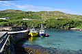
Inishturk pier
-
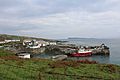
Harbour with Caher Island in background
-
Community centre
-
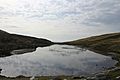
Freshwater lake
-
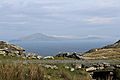
Clare Island as seen from Inishturk
-
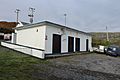
Power station


