
Irving, Kansas facts for kids
Quick facts for kids
Irving, Kansas
|
|
|---|---|

Irving stone marker, located where the post office once stood.
|
|

|
|

Irving, Kansas
Location in Kansas

Irving, Kansas
Location in the United States
|
|
| Country | United States |
| State | Kansas |
| County | Marshall |
| Founded | 1859 |
| Named for | Washington Irving |
| Elevation | 1,142 ft (348 m) |
| Population | |
| • Total | 0 |
| Time zone | UTC-6 (CST) |
| • Summer (DST) | UTC-5 (CDT) |
| FIPS code | 20-14325 |
| GNIS ID | 481910 |
Irving is a ghost town in Marshall County, Kansas, United States. It is located about six miles southeast of Blue Rapids. The town sits along the Big Blue River.
Irving became a ghost town because of the Tuttle Creek Lake project. This project was about ten miles south of Irving. Even though the lake never actually reached the town, the government made the people living there move out.
Contents
History of Irving
Early Days and Challenges
Irving was started in 1859 by a small group of people from Lyons, Iowa. They named the town after a famous writer, Washington Irving.
The early years were tough for Irving. In the spring of 1860, a very bad drought (a long period with no rain) ruined crops. This caused some farmers to lose their land. That summer, strong winds and thunderstorms hit the area. They blew down buildings and damaged a saw mill. Because of these problems, some people decided to leave and go back to Iowa.
Later, in 1866, the town faced another challenge: grasshoppers. These insects destroyed crops and damaged trees. Another grasshopper problem happened in 1875. Despite all these difficulties, by 1878, Irving was known as a town in a very good farming area of Marshall County.
The 1879 Tornadoes
On May 30, 1879, two powerful tornadoes struck Irving. They destroyed most of the town. Sadly, 19 people died, and many more were hurt.
A scientist named John Park Finley, who studied weather, looked closely at these tornadoes. It is even thought that L. Frank Baum, the author of Wonderful Wizard of Oz, might have named his main character, Dorothy Gale, after one of the tornado victims.
After the tornadoes, some residents left Irving. But the town was rebuilt, and new businesses opened. Irving became an important farming center in the area once again.
Floods and Growth
In the summer of 1903, the Big Blue River flooded. It destroyed homes, crops, and bridges. The river threatened to flood again in 1908. However, the townspeople were ready this time. They worked together and managed to keep the river from overflowing its banks.
By 1910, Irving had about 403 people. It had good banks, a weekly newspaper, and offices for telegraph and express services. There were also graded schools, a public library, and churches. Mail was delivered to homes on three rural routes from the Irving post office.
Becoming a Ghost Town
The population of Irving started to drop after plans for the Tuttle Creek Lake dam were announced. Many businesses, including the post office, closed down. The town site was completely empty by 1960, after the dam was built.
Even though the lake is miles away, Irving is still easy to visit. You can see its old road network and the foundations of buildings. There is a stone marker in a small park where the post office used to be. Visitors can write in a notebook kept in a mailbox there.
-
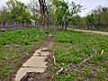
An abandoned sidewalk in Irving.

Education in Irving
The first schoolhouse in Irving was built in 1868. However, it was destroyed by the tornadoes in 1879. A new frame school building replaced the stone one in the same year.
Another school, the Wetmore Institute, was built around 1864. It was on a hill overlooking the town and named after A.H. Wetmore. This building was made of limestone. It was partly destroyed by the 1879 tornadoes and then burned down in 1880.
Notable People
- Ruth Alexander (1905–1930) - She was an important female pilot.
