Isle Phelipeaux facts for kids

Isle Phelipeaux (also spelled Isle Philippeaux) is like a ghost island in Lake Superior! It's known as a phantom island because, even though it appeared on many old maps, it doesn't actually exist. For a while in the late 1700s and early 1800s, people truly believed it was real.
This mysterious island was even important enough to be mentioned in the 1783 Treaty of Paris. This treaty helped set the boundary between the newly formed United States and what would later become Canada. Imagine using an island that isn't there to draw a country's border!
Some historians think Isle Phelipeaux might have been a mistake, perhaps a duplicate of Isle Royale, which is a real island nearby. Other islands that appeared on these old maps but might not be real include Pontchartrain, Maurepas, and St. Anne's. It's a fascinating puzzle from history!
Contents
The Mystery of the Missing Islands
The story of these phantom islands begins with a French priest and traveler named Pierre François Xavier de Charlevoix. He explored the Great Lakes region and wrote about his journeys. He decided to name some islands after his important supporter, Louis Phélypeaux. Louis Phélypeaux had titles like comte de Pontchartrain and comte de Maurepas, and his special saint was Saint Anne. This is how the names Pontchartrain, Maurepas, and St. Anne's appeared on maps.
How Maps Can Be Tricky
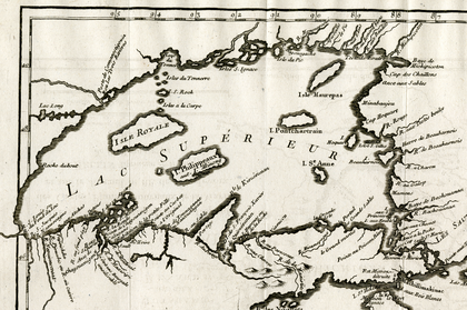
The islands first showed up on a map made in 1744 by Jacques-Nicolas Bellin, a famous mapmaker. Bellin used Charlevoix's travel notes to create his map. On Bellin's map, "I. Philippeaux" looked about the same size as the real Isle Royale. It was placed between Isle Royale and the Keweenaw Peninsula. Many experts believe that "I. Philippeaux" was actually just Isle Royale drawn twice by mistake, perhaps with a different name. Bellin even gave it another name, "I. Minong," which was also an old name for Isle Royale. Today, a large ridge on Isle Royale is still called Minong Ridge!
Other islands on Bellin's map also caused confusion:
- "I. Pontchartrain" was shown east of Isle Royale. It might have been a drawing of Michipicoten Island, which is a real island but wasn't on Bellin's map.
- "Isle Maurepas" was further northeast. It could have been another mistaken drawing of Michipicoten Island, or maybe it was meant to be the Slate Islands in the northern part of Lake Superior.
- "I. Se. Anne" was south of Pontchartrain. Its size and location suggest it might have been Caribou Island.

Drawing Borders with Phantom Islands
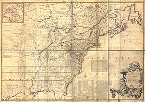
These maps, especially a very important one from 1755 called the Mitchell Map, were widely used. The Mitchell Map was so trusted that it became a key reference when the American Revolutionary War ended. In 1783, the Treaty of Paris was signed, officially ending the war and setting the boundaries for the new United States.
Part of the border description in the treaty said it would run "through Lake Superior northward of the Isles Royal and Phelipeaux to the Long Lake." This meant that Isle Phelipeaux was officially part of the border definition!
However, when surveyors went out in the 1820s to mark the exact international boundary from Lake of the Woods to Lake Superior, they ran into a big problem. They searched and searched, but they couldn't find "Isle Phelipeaux" anywhere! It simply didn't exist. They also couldn't figure out what the "Long Lake" mentioned in the treaty was. Because of these missing landmarks, the surveyors decided to use the Pigeon River as part of the boundary instead. This shows how important it is for maps to be accurate, especially when drawing borders between countries!
See also
 | Selma Burke |
 | Pauline Powell Burns |
 | Frederick J. Brown |
 | Robert Blackburn |

