Mitchell Map facts for kids
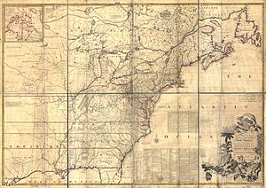
The Mitchell Map is a famous map created by John Mitchell (1711–1768). It was printed many times in the late 1700s. This map, officially called A map of the British and French dominions in North America was very important. It helped set the borders for the new United States after the Treaty of Paris in 1783.
Even much later, the Mitchell Map was still used. It helped solve arguments about borders between the United States and Canada. This happened as recently as the 1980s, for example, over fishing areas in the Gulf of Maine. The Mitchell Map is the most complete map of eastern North America from the time when it was still a colony. It is very large, about 6.5 feet (2 meters) wide and 4.5 feet (1.4 meters) high.
Contents
Why John Mitchell Made the Map
John Mitchell was not a professional map-maker. He was born into a rich family in Virginia. He studied medicine at Edinburgh University in Scotland. After his studies, he became a doctor and studied plants in Virginia.
In 1746, Mitchell and his wife had to move to London because he was sick. In London, he advised noblemen about unusual plants for their gardens. It was there that he made his famous map. Historians have wondered why a doctor who studied plants suddenly made such a big, detailed map.
For a long time, people thought Mitchell made the map on his own. They believed he wanted to warn British politicians about the French threat to the colonies. He supposedly showed his first map to politicians in 1750. George Montagu-Dunk, 2nd Earl of Halifax, who led the Board of Trade and Plantations, was very impressed. He then gave Mitchell access to official records and new maps from the colonies. This helped Mitchell create the better map published in 1755. This story suggested that a colonist took action to protect the colonies' future.
However, new information from old records tells a different story. Mitchell actually made his first map in 1750 because Halifax asked him to. Halifax became the head of the Board of Trade after the War of the Austrian Succession (1744–1748) ended. This war, also known as King George's War in North America, ended in a tie. Many people believed another war between Britain and France would start soon. They thought North America would be the main reason for this new conflict.
Halifax saw Mitchell as an expert on everything about the colonies. One of Halifax's requests was for Mitchell to make a new map. This map would show the land claims in North America. After 1749, Mitchell's letters show his new interest in geography and politics.
How the Map Was Created
Mitchell put together his first map in 1750. He used materials he found in London, from official records and private collections. But this first map was not good enough. So, Halifax ordered the governors of the British colonies to send new maps. Most governors did send them. These new maps became the main source for Mitchell's work. He used them with the overall geography from maps by the French map-maker Guillaume Delisle.
By late 1754, Halifax was using a handwritten copy of Mitchell's second map. He used it to convince the British government not to make deals with the French. This was happening as the Seven Years' War (also called the French and Indian War) was about to begin. Halifax also allowed Mitchell to publish the map. It came out in April 1755. Thomas Kitchin engraved it, and Andrew Millar published it.
The full title of the published map was very long. It was called A map of the British and French dominions in North America, with the roads, distances, limits, and extent of the settlements, humbly inscribed to the Right Honourable the Earl of Halifax, and the other Right Honourable the Lords Commissioners for Trade & Plantations. The map had a copyright date of February 13, 1755. But it was probably sold to the public in April or May. Small changes were made to the printing plates while the map was being printed. For example, the publisher's name and address were corrected. A copy of the map owned by King George III is now in the British Library.
Another map-maker, John Green, criticized Mitchell's map soon after it appeared. He pointed out problems with the map's details about Nova Scotia. This area was a big point of disagreement with the French. Mitchell then released a new version of his map. This new map included two large sections of text. These texts explained all the sources of his information. The new map also changed the coastline to match newer surveys. This "second edition" of the map was thought to have appeared in 1757. But newspaper ads from April 1756 show it was available then. The map continued to be updated even after Mitchell died in 1768.
Features of the Mitchell Map
Mitchell's map was printed on eight separate sheets. When put together, it measures about 4 feet 6 inches (136 cm) tall by 6 feet 5 inches (195 cm) wide. The first maps printed in 1755 had clear colors showing British land claims. Mitchell drew the southern colonies stretching all the way across the continent. This included land west of the Mississippi River, which Spain already claimed.
Mitchell also divided up the lands of the Iroquois people. He believed their territory reached from Lake Champlain to the Mississippi River. He also thought it went north of Lake Superior. He gave most of this land to Virginia and New York. This left only a much smaller area for the French.
The Mitchell Map was expensive. But it led to many cheaper versions. These cheaper maps helped spread Halifax and Mitchell's strong ideas about colonial power to the British public. One of these, published in December 1755, showed the French only having control over Quebec.
The map has many small notes written on it. These notes describe and explain different features. This is especially true for areas that were not well known or were argued over politically. Many notes describe the natural resources and how good frontier areas were for settlement. Others describe different Indian tribes. Many Indian settlements and important Indian trails are shown.
Mitchell's main goal was to show the French threat to the British colonies. Because of this, the map has a very strong pro-British bias. This is especially true when it comes to the Iroquois. The map clearly states that the Iroquois were not just allies of Britain, but subjects. This meant all Iroquois land was considered British territory. Huge parts of the continent are marked as British because the Iroquois had conquered other tribes. Any French activity in lands claimed by the Iroquois was shown as illegal.
When British and French land claims were unclear, Mitchell always favored the British side. So, many of his notes and borders look like political messages today. Some of the claims even seem to be completely false.
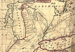
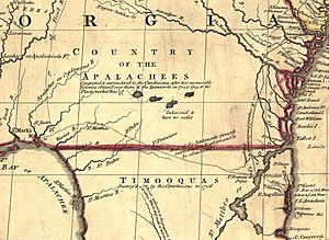
The map is very large, and the notes are often tiny. This makes it hard to read online. Smaller copies of the map often have notes that are impossible to read. Here are a few examples of the kinds of notes found on the map, using Mitchell's original spelling:
- In today's central Tennessee and Kentucky: A Fine Level Fertile Country of great Extent, by Accounts of the Indians and our People
- In the Great Plains: The Nadouessoians are reckoned one of the most Populous Nations of Indians in North America, altho' the number and situation of their Villages are not known nor laid down. (This refers to the Sioux people.)
- Along the coast of today's Texas: Wandering Savage Indians
- North of Lake Huron: MESSESAGUES—Subdued by the Iroquois and now united with them making the 8th Nation in that League. (This refers to the Mississaugas people.)
- Present-day Iowa: Extensive Meadows full of Buffaloes
- Sandusky, Ohio: Sandoski—Canahogue—The seat of War, the Mart of Trade, & chief Hunting Grounds of the Six Nations, on the Lakes & the Ohio.
- Illinois region: The Antient Eriez were extirpated by the Iroquois upwards of 100 years ago, ever since which time they have been in Possession of L. Erie (This refers to the Erie people.)
- Illinois region: The Six Nations have extended their Territories to the River Illinois, ever since the Year 1672, when they subdued, and were incorporated with, the Antient Chaouanons, the Native Proprietors of these Countries, and the River Ohio. Besides which they likewise claim a Right of Conquest over the Illinois, and all the Mississippi as far as they extend. This is confirmed by their own Claims and Possessions in 1742, which include all the Bounds here laid down, and none have ever thought fit to dispute them. (This refers to the Illiniwek people.)
- North Florida: TIMOOQUA—Destroy'd by the Carolinians in 1706 (This refers to the Timucua people.)
- South Georgia: COUNTRY OF THE APALACHEES—Conquered & surrendered to the Carolinians, after two memorable Victories obtain'd over them & the Spaniards in 1702 & 1703 at the Places marked thus [crossed-swords] (This refers to the Apalachee people.)
- Alabama area: The English have Factories & Settlements in all the Towns of the Creek Indians of any note, except Albamas; which was usurped by the French in 1715 but established by the English 28 years before. (This refers to the Creek people.)
The map also used names for places that are no longer used or were spelled strangely. For example:
- Des Moines River: Moingona River
- Kentucky River: Cuttawa or Catawba R.
- Tennessee River: River of the Cherakees, or Hogohegee R.
- Ohio River: Ohio or Splawacipiki R.
- Minnesota River: Ouadebameniſsouté or R. St. Peter (This name came from the Dakota language and French.)
The map also showed places that did not exist. One example is Isle Phelipeaux in Lake Superior. This island was also on earlier maps by Jacques-Nicolas Bellin.
The Map's Use in Treaties and Borders
The Mitchell Map was the most detailed map of North America available in the late 1700s. Different versions of the map (including French copies) were used by diplomats. They used it to draw the borders of the new United States of America. This happened during the 1783 Treaty of Paris, which ended the American Revolutionary War.
Because the map had some errors, it later caused several border disagreements. One example was in Maine. The map incorrectly showed the Mississippi River reaching north to the 50th parallel, into British land. This led to the treaty using it as a landmark for a border that was geographically impossible. It wasn't until 1842, with the Webster-Ashburton Treaty, that these problems were fixed. This treaty helped draw a clear border between the U.S. and Canada, from Maine to the Oregon Country.
Similarly, when the Northwest Ordinance was being written, the map's errors caused another problem. It showed incorrectly where an east-west line from the southernmost point of Lake Michigan would cross Lake Erie. This led to a long argument over the border between Ohio and Michigan. This argument eventually resulted in a conflict called the Toledo War.
 | James Van Der Zee |
 | Alma Thomas |
 | Ellis Wilson |
 | Margaret Taylor-Burroughs |


