
Jacaltenango facts for kids
Quick facts for kids
Jacaltenango
|
||
|---|---|---|
|
Municipality
|
||

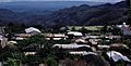
View of Jacaltenango in 1986
|
||
|
||

Jacaltenango
Location in Guatemala
|
||
| Country | ||
| Department | ||
| Municipality | Jacaltenango | |
| Area | ||
| • Municipality | 87 sq mi (225 km2) | |
| Elevation | 4,715 ft (1,437 m) | |
| Population
(Census 2018)
|
||
| • Municipality | 37,171 | |
| • Density | 427.9/sq mi (165.2/km2) | |
| • Urban | 22,533 | |
| • Ethnicities | Jakaltek Ladino | |
| • Religions | Roman Catholicism Evangelicalism Maya | |
| Climate | Cwb | |

Jacaltenango is a town and a surrounding area (called a municipality) in the western mountains of Guatemala. It sits in a valley, surrounded by the Sierra Madre Mountains. Jacaltenango is the main town for this municipality.
In 2018, the town's population was 22,533 people. The economy of Jacaltenango mostly relies on farming, especially coffee. About 95% of the crops grown here are sold to other places. The town has six schools, including elementary and high schools.
History of Jacaltenango
After the Spanish conquest of Guatemala in the 1520s, Spanish religious groups came to the area. One important group was the Mercedarian religious order. In 1565, they formed a special area called the "Presentación de Guatemala" province.
The Mercedarians first received control over some towns near the capital city, Santiago de los Caballeros de Guatemala. But they traded these towns with another group, the Dominican religious order. In return, the Mercedarians gained control of towns in the Sierra de los Cuchumatanes mountains.
By the early 1600s, the Mercedarians also managed four towns close to Santiago. These towns later became parts of the city. Their main center was in San Anton, where their leader lived.
Records from 1613 and 1770 show that the Mercedarians eventually managed nine main towns and many smaller villages. One of these important towns was Nuestra Señora de la Purificación de Jacaltenango.
However, in 1754, the Spanish kings made some big changes. These changes meant that religious orders like the Mercedarians had to give up control of their towns. Instead, local priests took over. This is how the Mercedarians lost their center in Jacaltenango and the villages connected to it.
Many people from Jacaltenango have moved to other countries, especially to places like Indiantown, Jupiter, West Palm Beach, and Lake Worth in Florida, USA. There is a large community of Guatemalan Mayas living there. Some of these people also live seasonally in Morganton, North Carolina.
Climate
Jacaltenango has a subtropical highland climate. This means it has mild temperatures all year round, with a rainy season and a drier season.
| Climate data for Jacaltenango | |||||||||||||
|---|---|---|---|---|---|---|---|---|---|---|---|---|---|
| Month | Jan | Feb | Mar | Apr | May | Jun | Jul | Aug | Sep | Oct | Nov | Dec | Year |
| Mean daily maximum °C (°F) | 25.1 (77.2) |
25.8 (78.4) |
27.3 (81.1) |
28.5 (83.3) |
27.4 (81.3) |
26.4 (79.5) |
25.6 (78.1) |
26.2 (79.2) |
25.6 (78.1) |
24.9 (76.8) |
25.1 (77.2) |
24.8 (76.6) |
26.1 (78.9) |
| Daily mean °C (°F) | 17.9 (64.2) |
18.3 (64.9) |
19.5 (67.1) |
20.9 (69.6) |
20.3 (68.5) |
20.4 (68.7) |
19.6 (67.3) |
19.9 (67.8) |
19.7 (67.5) |
19.1 (66.4) |
18.7 (65.7) |
18.1 (64.6) |
19.4 (66.9) |
| Mean daily minimum °C (°F) | 10.7 (51.3) |
10.8 (51.4) |
11.7 (53.1) |
13.3 (55.9) |
13.3 (55.9) |
14.5 (58.1) |
13.6 (56.5) |
13.7 (56.7) |
13.9 (57.0) |
13.4 (56.1) |
12.3 (54.1) |
11.4 (52.5) |
12.7 (54.9) |
| Average precipitation mm (inches) | 48 (1.9) |
18 (0.7) |
21 (0.8) |
65 (2.6) |
145 (5.7) |
563 (22.2) |
431 (17.0) |
357 (14.1) |
523 (20.6) |
363 (14.3) |
104 (4.1) |
63 (2.5) |
2,701 (106.5) |
| Source: Climate-Data.org | |||||||||||||
Where is Jacaltenango?
Jacaltenango is surrounded by other towns in the Huehuetenango Department:
 |
Nentón | |
||
| Santa Ana Huista | San Miguel Acatán | |||
| San Antonio Huista | Unión Cantinil | Concepción Huista |
Gallery
-
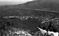
View of Jacaltenango from the Hermita San Sebastian (1986).
-
View of Jacaltenango and San Marcos beyond.

See also
 In Spanish: Jacaltenango para niños
