Jarrettsville, Maryland facts for kids
Quick facts for kids
Jarrettsville, Maryland
|
|
|---|---|

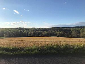
Chrome Hill Road (2021)
|
|

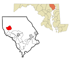
Location of Jarrettsville, Maryland
|
|
| Country | United States |
| State | Maryland |
| County | Harford |
| Area | |
| • Total | 8.66 sq mi (22.43 km2) |
| • Land | 8.63 sq mi (22.37 km2) |
| • Water | 0.03 sq mi (0.07 km2) |
| Elevation | 669 ft (204 m) |
| Population
(2020)
|
|
| • Total | 2,888 |
| • Density | 334.45/sq mi (129.13/km2) |
| Time zone | UTC−5 (Eastern (EST)) |
| • Summer (DST) | UTC−4 (EDT) |
| ZIP code |
21084
|
| Area code(s) | 410 |
| FIPS code | 24-42325 |
| GNIS feature ID | 0585205 |
Jarrettsville is a small community in Harford County, Maryland, in the United States. It is known as a census-designated place (CDP). This means it's a special area defined by the government for counting people. In 2020, about 2,888 people lived there.
Contents
A Look Back: Jarrettsville's History
This area was first called Carmon. Later, it was named Jarrettsville after the Jarrett family. They were one of the first pioneer families in the United States. They farmed the land in the 1800s.
In 1771, a man named Abraham Jarrett was given a large piece of land. It was about 2,380 acres. This land was used to make large wooden barrels called hogsheads. These barrels were mainly used to transport tobacco. Abraham Jarrett bought more land around Jarrettsville that same year. He married Martha Bussey, and they had seven children.
A place called My Lady's Manor was added to the National Register of Historic Places in 1978. Parts of Jarrettsville are included in this historic area. Some people believe that Abraham Jarrett's grandson, Luther M. Jarrett, is actually who the town was named after. Luther M. Jarrett was a farmer and also a state delegate.
Where is Jarrettsville? (Geography)
Jarrettsville is located in the northwestern part of Harford County. You can find it at these coordinates: 39°36′7″N 76°28′21″W / 39.60194°N 76.47250°W.
Two main roads pass through the center of Jarrettsville. Maryland Route 23 goes southeast about 9 miles to Bel Air. Bel Air is the county seat, which means it's where the county government is located. Route 23 also goes northwest about 12 miles to the Pennsylvania border. This is north of Norrisville.
Maryland Route 165 also goes through Jarrettsville. It heads northeast about 12 miles to the Pennsylvania border near Cardiff. It also goes south about 8 miles to Baldwin. Jarrettsville is about 30 miles northeast of downtown Baltimore.
The total area of Jarrettsville is about 22.4 square kilometers (about 8.6 square miles). Only a very small part, about 0.07 square kilometers (0.03 square miles), is water.
Who Lives in Jarrettsville? (Population)
| Historical population | |||
|---|---|---|---|
| Census | Pop. | %± | |
| 2020 | 2,888 | — | |
| U.S. Decennial Census | |||
Let's look at the people who live in Jarrettsville. In the year 2000, there were 2,756 people living there. They lived in 900 households, and 781 of these were families.
Most people in Jarrettsville are White. A small number of people are African American, Native American, or Asian. Some people are from other backgrounds or have mixed backgrounds. A small percentage of the population is Hispanic or Latino.
Many households, about 43.7%, had children under 18 living with them. Most households, about 77.6%, were married couples living together. The average household had about 3 people. The average family had about 3.3 people.
The population in Jarrettsville is spread out by age. About 28.9% of the people were under 18 years old. About 9.2% were 65 years or older. The average age of people living there was 39 years old.
Famous People from Jarrettsville
- Mel Kiper Jr. - He is a well-known ESPN analyst for the NFL draft.
- Randy McMillan - He used to be a running back in the NFL for the Baltimore/Indianapolis Colts.
See also
 In Spanish: Jarrettsville (Maryland) para niños
 | Sharif Bey |
 | Hale Woodruff |
 | Richmond Barthé |
 | Purvis Young |

